Property Record
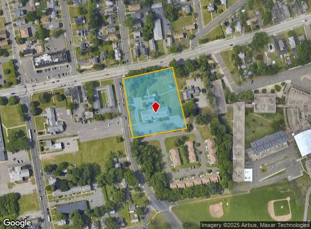
745 Burnside Ave, East Hartford, CT 06108
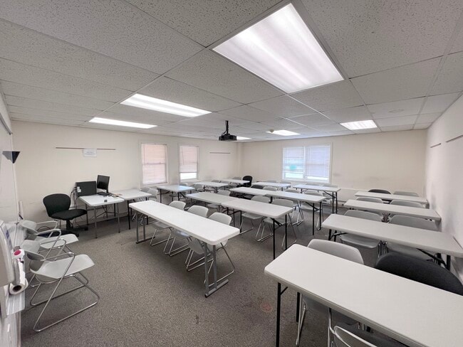
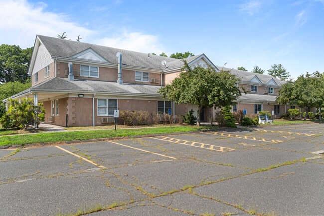
This Property Is For Sale
NEARBY LISTINGS FOR SALE OR LEASE
-
-
View all East Hartford listings for sale on LoopNet.com
Property Detail
745 Burnside Ave
EHAR-000047-000000-000065
Hartford
Commercialnec
Connecticut
X
65
09003C0388F
2.45 AC
2025
East Hartford
2025
Hartford
511300
Hartford-West Hartford-East Hartford, CT
DEMOGRAPHICS near 745 Burnside Ave
1 Mile
3 Mile
5 Mile
2024 Total Population
13,428
56,044
212,840
2029 Population
13,397
55,819
212,363
Pop Growth 2024-2029
(0.23%)
(0.40%)
(0.22%)
Average Age
37
39
38
2024 Total Households
5,176
22,193
86,556
HH Growth 2024-2029
(0.21%)
(0.43%)
(0.12%)
Median Household Inc
$51,154
$63,886
$57,159
Avg Household Size
2.50
2.40
2.30
2024 Avg HH Vehicles
1.00
2.00
1.00
Median Home Value
$182,376
$196,248
$208,975
Median Year Built
1964
1963
1961
Nearby Places
- Restaurants
- Banks
- Shops
- Fitness
- Groceries
PUBLIC TRANSPORTATION
COMMUTER RAIL
DRIVE
WALK
Distance
10 min
4.6 mi
DRIVE
WALK
Distance
10 min
4.6 mi
AIRPORT
Bradley International
DRIVE
WALK
Distance
Bradley International
28 min
16.0 mi
Freight Ports
Port of New Haven
DRIVE
WALK
Distance
Port of New Haven
56 min
42.1 mi
Nearby Properties
Address
Land Use
TOTAL SIZE
Lot Size
Zoning
Address
Land Use
TOTAL SIZE
Lot Size
Zoning
159 AC
RR
Address
Land Use
TOTAL SIZE
Lot Size
Zoning
149.23 AC
DDD1
Address
Land Use
TOTAL SIZE
Lot Size
Zoning
112.42 AC
DDD1
Address
Land Use
TOTAL SIZE
Lot Size
Zoning
2,500 SF
74.98 AC
I-2
Address
Land Use
TOTAL SIZE
Lot Size
Zoning
194,971 SF
162.43 AC
IND
Address
Land Use
TOTAL SIZE
Lot Size
Zoning
9.92 AC
DDD1
Address
Land Use
TOTAL SIZE
Lot Size
Zoning
14.56 AC
SDD/BG
Address
Land Use
TOTAL SIZE
Lot Size
Zoning
36.69 AC
R-5
Address
Land Use
TOTAL SIZE
Lot Size
Zoning
10.74 AC
ID-1
Address
Land Use
TOTAL SIZE
Lot Size
Zoning
132,110 SF
1 AC
I
Address
Land Use
TOTAL SIZE
Lot Size
Zoning
13.34 AC
PD
Address
Land Use
TOTAL SIZE
Lot Size
Zoning
43,711 SF
1 AC
I
Address
Land Use
TOTAL SIZE
Lot Size
Zoning
348,943 SF
51.21 AC
R-2
Address
Land Use
TOTAL SIZE
Lot Size
Zoning
Address
Land Use
TOTAL SIZE
Lot Size
Zoning
58,778 SF
9.26 AC
R-4
Address
Land Use
TOTAL SIZE
Lot Size
Zoning
18.26 AC
R-5
Address
Land Use
TOTAL SIZE
Lot Size
Zoning
421,152 SF
45.95 AC
CD
Address
Land Use
TOTAL SIZE
Lot Size
Zoning
1,920 SF
31 AC
RC
Address
Land Use
TOTAL SIZE
Lot Size
Zoning
356,062 SF
23.10 AC
ID-2
Address
Land Use
TOTAL SIZE
Lot Size
Zoning
29.90 AC
PRD
Address
Land Use
TOTAL SIZE
Lot Size
Zoning
38.80 AC
R-3
Address
Land Use
TOTAL SIZE
Lot Size
Zoning
66.09 AC
CX-2
Address
Land Use
TOTAL SIZE
Lot Size
Zoning
6.61 AC
B-4
Address
Land Use
TOTAL SIZE
Lot Size
Zoning
126,934 SF
1.51 AC
B-4
Address
Land Use
TOTAL SIZE
Lot Size
Zoning
498,105 SF
29.55 AC
IND
Address
Land Use
TOTAL SIZE
Lot Size
Zoning
181,421 SF
18.36 AC
DDD1
Address
Land Use
TOTAL SIZE
Lot Size
Zoning
57,140 SF
1 AC
I
Address
Land Use
TOTAL SIZE
Lot Size
Zoning
101,317 SF
24.91 AC
RR
Address
Land Use
TOTAL SIZE
Lot Size
Zoning
209,744 SF
25.67 AC
CD
Address
Land Use
TOTAL SIZE
Lot Size
Zoning
259,600 SF
25.58 AC
CD
The World's #1 Commercial Real Estate Marketplace
Connect with us
© 2025 CoStar Group
The information above has been obtained from sources believed reliable. While we do not doubt its accuracy we have not verified it and make no guarantee, warranty or representation about it. It is your responsibility to independently confirm its accuracy and completeness. Any projections, opinions, assumptions, or estimates used are for example only and do not represent the current or future performance of the property. The value of this transaction to you depends on tax and other factors which should be evaluated by your tax, financial, and legal advisors. You and your advisors should conduct a careful, independent investigation of the property to determine to your satisfaction the suitability of the property for your needs.