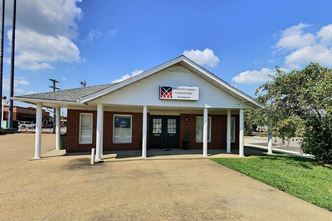
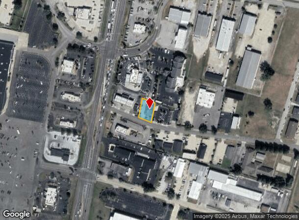
Property Record
745 Carlton Dr, Owensboro, KY 42303
NEARBY LISTINGS FOR SALE OR LEASE
Property Detail
745 Carlton Dr
003-12-27-034-S0-000
Taylor Mitchell
Commercialnec
3-12-27-34S745 CARLTON DR.246 ACRE
X
Daviess
21059C0276E
Kentucky
2025
0.25 AC
2025
Kentucky West Area
001702
Other Market Areas
1,995 SF
Owensboro, KY
DEMOGRAPHICS near 745 Carlton Dr
1 Mile
3 Mile
5 Mile
2024 Total Population
6,046
43,127
73,613
2029 Population
6,035
43,252
73,831
Pop Growth 2024-2029
(0.18%)
+ 0.29%
+ 0.30%
Average Age
40
41
40
2024 Total Households
2,597
18,431
30,201
HH Growth 2024-2029
(0.23%)
+ 0.32%
+ 0.31%
Median Household Inc
$56,705
$54,199
$55,168
Avg Household Size
2.20
2.20
2.30
2024 Avg HH Vehicles
2.00
2.00
2.00
Median Home Value
$143,681
$155,331
$159,829
Median Year Built
1973
1970
1973
Nearby Places
Map Layers
Map Styles
 Street
 Aerial
- Restaurants
- Banks
- Shops
- Fitness
- Groceries
PUBLIC TRANSPORTATION
AIRPORT
Evansville Regional
DRIVE
WALK
Distance
Evansville Regional
59 min
42.8 mi
SALE & LEASE HISTORY
LISTING DATE
SALE/LEASE

Jul 28, 2022
For Lease
Nearby Properties
Address
Land Use
TOTAL SIZE
Lot Size
Zoning
Address
Land Use
TOTAL SIZE
Lot Size
Zoning
184,854 SF
9.46 AC
Address
Land Use
TOTAL SIZE
Lot Size
Zoning
270,464 SF
100.67 AC
Address
Land Use
TOTAL SIZE
Lot Size
Zoning
198,394 SF
49.52 AC
Address
Land Use
TOTAL SIZE
Lot Size
Zoning
371,705 SF
57.02 AC
Address
Land Use
TOTAL SIZE
Lot Size
Zoning
424,078 SF
43.02 AC
Address
Land Use
TOTAL SIZE
Lot Size
Zoning
227,450 SF
30.70 AC
Address
Land Use
TOTAL SIZE
Lot Size
Zoning
187,364 SF
18.64 AC
Address
Land Use
TOTAL SIZE
Lot Size
Zoning
29,600 SF
3.38 AC
Address
Land Use
TOTAL SIZE
Lot Size
Zoning
165,207 SF
15.76 AC
Address
Land Use
TOTAL SIZE
Lot Size
Zoning
215,439 SF
15.02 AC
Address
Land Use
TOTAL SIZE
Lot Size
Zoning
53,280 SF
Address
Land Use
TOTAL SIZE
Lot Size
Zoning
326,232 SF
29.64 AC
Address
Land Use
TOTAL SIZE
Lot Size
Zoning
54,713 SF
20 AC
Address
Land Use
TOTAL SIZE
Lot Size
Zoning
122,450 SF
7.63 AC
Address
Land Use
TOTAL SIZE
Lot Size
Zoning
193,067 SF
19.80 AC
Address
Land Use
TOTAL SIZE
Lot Size
Zoning
155,700 SF
7.78 AC
Address
Land Use
TOTAL SIZE
Lot Size
Zoning
85,349 SF
9.23 AC
Address
Land Use
TOTAL SIZE
Lot Size
Zoning
82,396 SF
28.50 AC
Address
Land Use
TOTAL SIZE
Lot Size
Zoning
4.35 AC
Address
Land Use
TOTAL SIZE
Lot Size
Zoning
24.58 AC
Address
Land Use
TOTAL SIZE
Lot Size
Zoning
212,423 SF
Address
Land Use
TOTAL SIZE
Lot Size
Zoning
17,289 SF
810.94 AC
Address
Land Use
TOTAL SIZE
Lot Size
Zoning
116,601 SF
15.72 AC
Address
Land Use
TOTAL SIZE
Lot Size
Zoning
44,887 SF
4.31 AC
Address
Land Use
TOTAL SIZE
Lot Size
Zoning
17,920 SF
10.60 AC
Address
Land Use
TOTAL SIZE
Lot Size
Zoning
125,000 SF
20.10 AC
Address
Land Use
TOTAL SIZE
Lot Size
Zoning
46,844 SF
2.72 AC
Address
Land Use
TOTAL SIZE
Lot Size
Zoning
135,855 SF
18.24 AC
Address
Land Use
TOTAL SIZE
Lot Size
Zoning
63,050 SF
6.91 AC
Address
Land Use
TOTAL SIZE
Lot Size
Zoning
101,268 SF
49.13 AC
The World's #1 Commercial Real Estate Marketplace
Connect with us
© 2025 CoStar Group
The information above has been obtained from sources believed reliable. While we do not doubt its accuracy we have not verified it and make no guarantee, warranty or representation about it. It is your responsibility to independently confirm its accuracy and completeness. Any projections, opinions, assumptions, or estimates used are for example only and do not represent the current or future performance of the property. The value of this transaction to you depends on tax and other factors which should be evaluated by your tax, financial, and legal advisors. You and your advisors should conduct a careful, independent investigation of the property to determine to your satisfaction the suitability of the property for your needs.