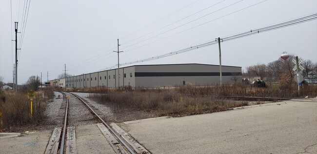
Property Record
745 S Bird St, Sun Prairie, WI 53590


NEARBY LISTINGS FOR SALE OR LEASE
Property Detail
745 S Bird St
Madison, WI
Certified Surv Map #12539
0811-082-5415-2
LOT 1 CSM 12539 CS78/241&242-9/12/2008 F/K/A ROYLE ADDITION LOT 7 & 8 DESCR AS S EC 8-8-11 PRT SW1/4 NW1/4 & PRT NW1/4SW1/4 (9.166 ACRES)
Industrialgeneral
Dane
X
Wisconsin
55025C0286H
1,7,8
2024
9.17 AC
2024
Northeast Madison
011506
Milwaukee/Madison
DEMOGRAPHICS near 745 S Bird St
1 Mile
3 Mile
5 Mile
2024 Total Population
7,711
39,990
58,626
2029 Population
8,069
41,573
61,029
Pop Growth 2024-2029
+ 4.64%
+ 3.96%
+ 4.10%
Average Age
37
38
38
2024 Total Households
3,179
15,947
23,837
HH Growth 2024-2029
+ 4.81%
+ 4.13%
+ 4.29%
Median Household Inc
$57,687
$86,451
$86,815
Avg Household Size
2.30
2.40
2.40
2024 Avg HH Vehicles
1.00
2.00
2.00
Median Home Value
$248,709
$315,475
$317,535
Median Year Built
1979
1996
1996
Nearby Places
Map Layers
Map Styles
 Street
 Aerial
- Restaurants
- Banks
- Shops
- Fitness
- Groceries
PUBLIC TRANSPORTATION
AIRPORT
Dane County Regional/Truax Field
DRIVE
WALK
Distance
Dane County Regional/Truax Field
19 min
10.3 mi
Freight Ports
Port Milwaukee
DRIVE
WALK
Distance
Port Milwaukee
92 min
75.0 mi
SALE & LEASE HISTORY
LISTING DATE
SALE/LEASE

Jan 14, 2022
For Sale
Nearby Properties
Address
Land Use
TOTAL SIZE
Lot Size
Zoning
Address
Land Use
TOTAL SIZE
Lot Size
Zoning
8.49 AC
SFR
Address
Land Use
TOTAL SIZE
Lot Size
Zoning
Address
Land Use
TOTAL SIZE
Lot Size
Zoning
58,272 SF
136.54 AC
SO
Address
Land Use
TOTAL SIZE
Lot Size
Zoning
8.56 AC
Address
Land Use
TOTAL SIZE
Lot Size
Zoning
26.32 AC
Address
Land Use
TOTAL SIZE
Lot Size
Zoning
4.64 AC
Address
Land Use
TOTAL SIZE
Lot Size
Zoning
31,986 SF
5 AC
PD
Address
Land Use
TOTAL SIZE
Lot Size
Zoning
46,902 SF
5.28 AC
PD
Address
Land Use
TOTAL SIZE
Lot Size
Zoning
222,532 SF
18.02 AC
PD
Address
Land Use
TOTAL SIZE
Lot Size
Zoning
Address
Land Use
TOTAL SIZE
Lot Size
Zoning
3.03 AC
RH-35
Address
Land Use
TOTAL SIZE
Lot Size
Zoning
4,542 SF
10.01 AC
PD
Address
Land Use
TOTAL SIZE
Lot Size
Zoning
Address
Land Use
TOTAL SIZE
Lot Size
Zoning
70,080 SF
3.21 AC
Address
Land Use
TOTAL SIZE
Lot Size
Zoning
26,854 SF
8.25 AC
UR12
Address
Land Use
TOTAL SIZE
Lot Size
Zoning
147,310 SF
14.68 AC
SC
Address
Land Use
TOTAL SIZE
Lot Size
Zoning
12.16 AC
Address
Land Use
TOTAL SIZE
Lot Size
Zoning
Address
Land Use
TOTAL SIZE
Lot Size
Zoning
152,636 SF
13.28 AC
Address
Land Use
TOTAL SIZE
Lot Size
Zoning
72,072 SF
11.78 AC
Address
Land Use
TOTAL SIZE
Lot Size
Zoning
Address
Land Use
TOTAL SIZE
Lot Size
Zoning
84,541 SF
10.54 AC
PD
Address
Land Use
TOTAL SIZE
Lot Size
Zoning
430,172 SF
18.33 AC
SI
Address
Land Use
TOTAL SIZE
Lot Size
Zoning
Address
Land Use
TOTAL SIZE
Lot Size
Zoning
11.28 AC
Address
Land Use
TOTAL SIZE
Lot Size
Zoning
15.38 AC
Address
Land Use
TOTAL SIZE
Lot Size
Zoning
133,853 SF
12.95 AC
PD
Address
Land Use
TOTAL SIZE
Lot Size
Zoning
22,866 SF
5.39 AC
PD
Address
Land Use
TOTAL SIZE
Lot Size
Zoning
16,464 SF
7.37 AC
UR12
Address
Land Use
TOTAL SIZE
Lot Size
Zoning
2.80 AC
PD
The World's #1 Commercial Real Estate Marketplace
Connect with us
© 2026 CoStar Group
The information above has been obtained from sources believed reliable. While we do not doubt its accuracy we have not verified it and make no guarantee, warranty or representation about it. It is your responsibility to independently confirm its accuracy and completeness. Any projections, opinions, assumptions, or estimates used are for example only and do not represent the current or future performance of the property. The value of this transaction to you depends on tax and other factors which should be evaluated by your tax, financial, and legal advisors. You and your advisors should conduct a careful, independent investigation of the property to determine to your satisfaction the suitability of the property for your needs.