Property Record
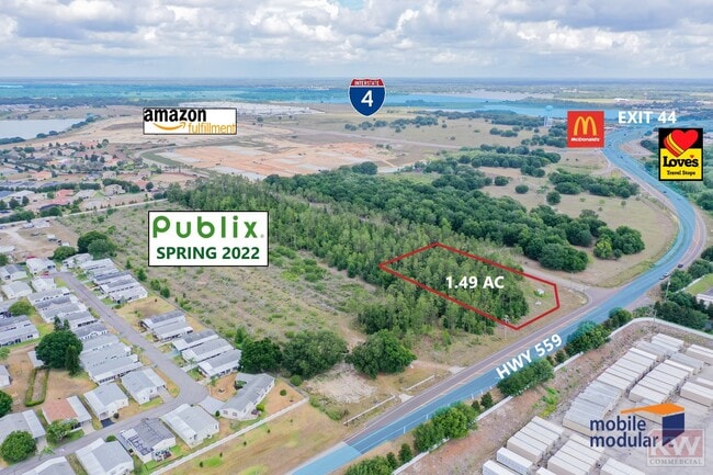
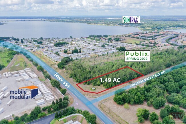
745 Highway 559, Auburndale, FL 33823
NEARBY LISTINGS FOR SALE OR LEASE
Property Detail
745 Highway 559
Lakeland-Winter Haven, FL
Alameda Heights
25-27-10-000000-042060
COMM SW COR N1/2 OF SE1/4 OF SW1/4 N00-16-54E 637.04 FT TO S MAINT R/W FOR VAN FLEET RD PER MB 15 PG 94 S89-50-18E 84.88 FT N89-50-20E 100 FT S89-53-48E 100 FT N89-55-54E 100 FT S89-43-29E 100 FT S89-39-03E 100 FT S88-14-08E 100.04 FT S89-29-44E 46.5
Commercialacreage
Polk
X
Florida
12105C0195G
1.49 AC
2024
Polk County
2025
Tampa/St Petersburg
013102
DEMOGRAPHICS near 745 Highway 559
1 Mile
3 Mile
5 Mile
2024 Total Population
6,910
33,530
68,336
2029 Population
8,410
40,731
82,952
Pop Growth 2024-2029
+ 21.71%
+ 21.48%
+ 21.39%
Average Age
40
40
41
2024 Total Households
2,427
12,443
26,041
HH Growth 2024-2029
+ 21.55%
+ 21.31%
+ 21.28%
Median Household Inc
$90,436
$63,080
$55,418
Avg Household Size
2.80
2.70
2.60
2024 Avg HH Vehicles
2.00
2.00
2.00
Median Home Value
$256,658
$232,773
$202,856
Median Year Built
1999
1990
1988
Nearby Places
Map Layers
Map Styles
 Street
 Aerial
- Restaurants
- Banks
- Shops
- Fitness
- Groceries
SALE & LEASE HISTORY
LISTING DATE
SALE/LEASE

Sep 10, 2021
For Sale
Jun 24, 2021
For Sale
Nearby Properties
Address
Land Use
TOTAL SIZE
Lot Size
Zoning
Address
Land Use
TOTAL SIZE
Lot Size
Zoning
1,277,914 SF
138.39 AC
Address
Land Use
TOTAL SIZE
Lot Size
Zoning
193,500 SF
26.02 AC
RC
Address
Land Use
TOTAL SIZE
Lot Size
Zoning
463,500 SF
27.88 AC
Address
Land Use
TOTAL SIZE
Lot Size
Zoning
422,812 SF
38.60 AC
Address
Land Use
TOTAL SIZE
Lot Size
Zoning
475,612 SF
35.07 AC
RC
Address
Land Use
TOTAL SIZE
Lot Size
Zoning
62,638 SF
8.27 AC
Address
Land Use
TOTAL SIZE
Lot Size
Zoning
158,057 SF
405.79 AC
RC
Address
Land Use
TOTAL SIZE
Lot Size
Zoning
50,128 SF
4.96 AC
Address
Land Use
TOTAL SIZE
Lot Size
Zoning
126,726 SF
16.08 AC
RC
Address
Land Use
TOTAL SIZE
Lot Size
Zoning
75.70 AC
RC
Address
Land Use
TOTAL SIZE
Lot Size
Zoning
90,220 SF
26.99 AC
Address
Land Use
TOTAL SIZE
Lot Size
Zoning
30,568 SF
60.79 AC
RC
Address
Land Use
TOTAL SIZE
Lot Size
Zoning
15,832 SF
16.09 AC
XX
Address
Land Use
TOTAL SIZE
Lot Size
Zoning
76.28 AC
Address
Land Use
TOTAL SIZE
Lot Size
Zoning
71,028 SF
6.38 AC
Address
Land Use
TOTAL SIZE
Lot Size
Zoning
45,769 SF
15.45 AC
Address
Land Use
TOTAL SIZE
Lot Size
Zoning
12,988 SF
16.11 AC
Address
Land Use
TOTAL SIZE
Lot Size
Zoning
21,536 SF
4.13 AC
Address
Land Use
TOTAL SIZE
Lot Size
Zoning
21,090 SF
2.48 AC
Address
Land Use
TOTAL SIZE
Lot Size
Zoning
12,804 SF
2.55 AC
Address
Land Use
TOTAL SIZE
Lot Size
Zoning
18,898 SF
4.34 AC
Address
Land Use
TOTAL SIZE
Lot Size
Zoning
118.69 AC
Address
Land Use
TOTAL SIZE
Lot Size
Zoning
4,392 SF
1 AC
Address
Land Use
TOTAL SIZE
Lot Size
Zoning
5,000 SF
3.40 AC
XX
Address
Land Use
TOTAL SIZE
Lot Size
Zoning
19.63 AC
RC
Address
Land Use
TOTAL SIZE
Lot Size
Zoning
1,216 SF
28.17 AC
RC
Address
Land Use
TOTAL SIZE
Lot Size
Zoning
4,508 SF
1.05 AC
Address
Land Use
TOTAL SIZE
Lot Size
Zoning
10,192 SF
0.89 AC
XX
Address
Land Use
TOTAL SIZE
Lot Size
Zoning
159.60 AC
The World's #1 Commercial Real Estate Marketplace
Connect with us
© 2025 CoStar Group
The information above has been obtained from sources believed reliable. While we do not doubt its accuracy we have not verified it and make no guarantee, warranty or representation about it. It is your responsibility to independently confirm its accuracy and completeness. Any projections, opinions, assumptions, or estimates used are for example only and do not represent the current or future performance of the property. The value of this transaction to you depends on tax and other factors which should be evaluated by your tax, financial, and legal advisors. You and your advisors should conduct a careful, independent investigation of the property to determine to your satisfaction the suitability of the property for your needs.