Property Record
7450 Coca Cola Dr, Hanover, MD 21076
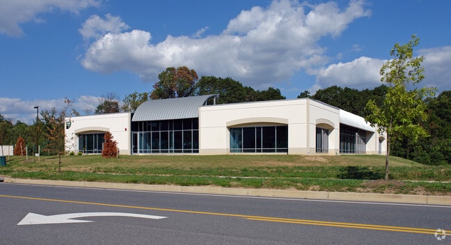


Property Detail
7450 Coca Cola Dr
01-291343
PAR G1 12.404 A. 7450 COCA COLA DR PATAPSCO VALLEY BUSINESS
Officebuilding
Howard
M2
Maryland
AE The base floodplain where base flood elevations are provided. AE Zones are now used on new format FIRMs instead of A1-A30 Zones.
g 1
2024
12.40 AC
2025
BWI Howard County
601204
Baltimore
12,374 SF
Baltimore-Columbia-Towson, MD
NEARBY LISTINGS FOR SALE OR LEASE
DEMOGRAPHICS near 7450 Coca Cola Dr
1 mile
3 mile
5 mile
2025 Total Population
8,013
48,816
161,651
2030 Population
8,287
49,929
163,846
Pop Growth 2025-2030
+ 3.42%
+ 2.28%
+ 1.36%
Average Age
36
37
38
2025 Total Households
2,802
17,699
57,251
HH Growth 2025-2030
+ 3.43%
+ 2.29%
+ 1.36%
Median Household Inc
$143,729
$134,593
$127,555
Avg Household Size
2.80
2.70
2.70
2025 Avg HH Vehicles
2.00
2.00
2.00
Median Home Value
$490,149
$468,583
$452,089
Median Year Built
2007
2000
1991
Nearby Places
Map Layers
Map Styles
 Street
 Aerial
Transit
 Traffic
 Biking
Places
Listings with unknown addresses are not visible on the map
- Restaurants
- Banks
- Shops
- Fitness
- Groceries
PUBLIC TRANSPORTATION
COMMUTER RAIL
Drive
Walk
Distance
5 min
1.8 mi
Drive
Walk
Distance
5 min
1.8 mi
AIRPORT
Baltimore/Washington International Thurgood Marshall
Drive
Walk
Distance
Baltimore/Washington International Thurgood Marshall
12 min
4.8 mi
Ronald Reagan Washington Ntl
Drive
Walk
Distance
Ronald Reagan Washington Ntl
53 min
34.0 mi
Freight Ports
Port of Baltimore
Drive
Walk
Distance
Port of Baltimore
22 min
14.2 mi
Nearby Properties
Address
Land Use
TOTAL SIZE
Lot Size
Zoning
Address
Land Use
TOTAL SIZE
Lot Size
Zoning
1,593,623 SF
176.09 AC
W1
Address
Land Use
TOTAL SIZE
Lot Size
Zoning
2,583,263 SF
12.57 AC
W1
Address
Land Use
TOTAL SIZE
Lot Size
Zoning
732,668 SF
13.26 AC
MXDE
Address
Land Use
TOTAL SIZE
Lot Size
Zoning
14.68 AC
C2
Address
Land Use
TOTAL SIZE
Lot Size
Zoning
120,108 SF
28.23 AC
TOD
Address
Land Use
TOTAL SIZE
Lot Size
Zoning
305,483 SF
11.38 AC
MXDT
Address
Land Use
TOTAL SIZE
Lot Size
Zoning
332,190 SF
21.80 AC
W1-BW
Address
Land Use
TOTAL SIZE
Lot Size
Zoning
560,407 SF
3.82 AC
Address
Land Use
TOTAL SIZE
Lot Size
Zoning
154,666 SF
27.65 AC
M1
Address
Land Use
TOTAL SIZE
Lot Size
Zoning
5.34 AC
Address
Land Use
TOTAL SIZE
Lot Size
Zoning
454,684 SF
6.88 AC
W1B
Address
Land Use
TOTAL SIZE
Lot Size
Zoning
87,344 SF
5.46 AC
CECLI
Address
Land Use
TOTAL SIZE
Lot Size
Zoning
221,100 SF
1.75 AC
MXD-E
Address
Land Use
TOTAL SIZE
Lot Size
Zoning
11.09 AC
C2
Address
Land Use
TOTAL SIZE
Lot Size
Zoning
21,240 SF
20.31 AC
RA 15
Address
Land Use
TOTAL SIZE
Lot Size
Zoning
490,875 SF
9.52 AC
MXD-E
Address
Land Use
TOTAL SIZE
Lot Size
Zoning
292,269 SF
15.86 AC
W1-BW
Address
Land Use
TOTAL SIZE
Lot Size
Zoning
202,692 SF
4.28 AC
TOD
Address
Land Use
TOTAL SIZE
Lot Size
Zoning
359,185 SF
3.63 AC
TOD
Address
Land Use
TOTAL SIZE
Lot Size
Zoning
231,128 SF
8.30 AC
W1-BW
Address
Land Use
TOTAL SIZE
Lot Size
Zoning
55,400 SF
10.19 AC
CACLI
Address
Land Use
TOTAL SIZE
Lot Size
Zoning
1,489,438 SF
74.22 AC
W2
Address
Land Use
TOTAL SIZE
Lot Size
Zoning
79,448 SF
8.11 AC
TOD
Address
Land Use
TOTAL SIZE
Lot Size
Zoning
307,032 SF
4.35 AC
TOD
Address
Land Use
TOTAL SIZE
Lot Size
Zoning
53,024 SF
10.02 AC
CACLI
Address
Land Use
TOTAL SIZE
Lot Size
Zoning
271,600 SF
30.43 AC
M1
Address
Land Use
TOTAL SIZE
Lot Size
Zoning
259,502 SF
16.17 AC
W1B
Address
Land Use
TOTAL SIZE
Lot Size
Zoning
151,844 SF
5.77 AC
CACLI
Address
Land Use
TOTAL SIZE
Lot Size
Zoning
132,552 SF
47.72 AC
RED
Address
Land Use
TOTAL SIZE
Lot Size
Zoning
185,652 SF
18.76 AC
W1
The World's #1 Commercial Real Estate Marketplace
Connect with us
© 2026 CoStar Group
The information above has been obtained from sources believed reliable. While we do not doubt its accuracy we have not verified it and make no guarantee, warranty or representation about it. It is your responsibility to independently confirm its accuracy and completeness. Any projections, opinions, assumptions, or estimates used are for example only and do not represent the current or future performance of the property. The value of this transaction to you depends on tax and other factors which should be evaluated by your tax, financial, and legal advisors. You and your advisors should conduct a careful, independent investigation of the property to determine to your satisfaction the suitability of the property for your needs.