Property Record
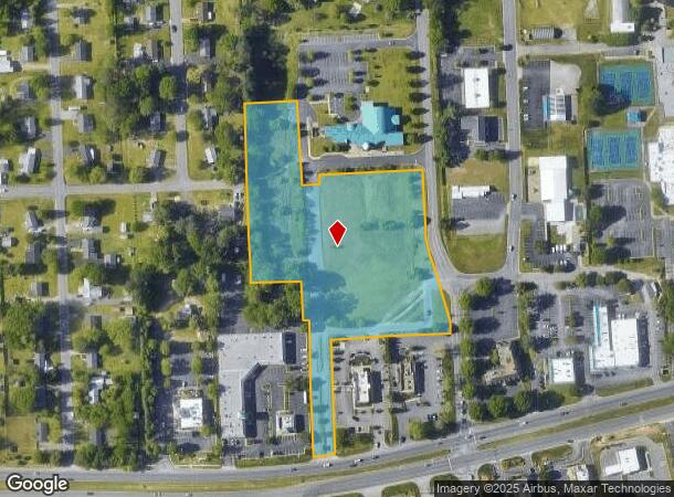
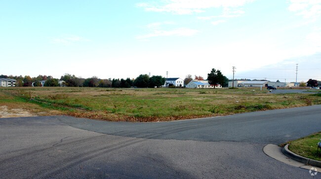
7451 Mechanicsville Elementary Dr, Mechanicsville, VA 23111
NEARBY LISTINGS FOR SALE OR LEASE
Property Detail
7451 Mechanicsville Elementary Dr
Richmond, VA
Trilogy
8714-78-5898
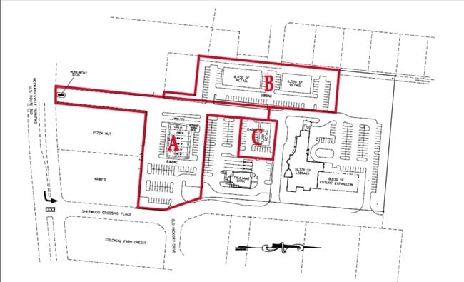
SHERWOOD CROSSING II
Commercialnec
Hanover
X
Virginia
51085C0426C
3
2025
6.03 AC
2025
Mechanicsville
321100
Richmond VA
DEMOGRAPHICS near 7451 Mechanicsville Elementary Dr
1 Mile
3 Mile
5 Mile
2024 Total Population
6,189
36,880
92,152
2029 Population
6,651
39,146
95,566
Pop Growth 2024-2029
+ 7.46%
+ 6.14%
+ 3.70%
Average Age
46
42
41
2024 Total Households
2,618
14,427
36,449
HH Growth 2024-2029
+ 7.68%
+ 6.29%
+ 3.67%
Median Household Inc
$69,420
$85,735
$73,124
Avg Household Size
2.30
2.50
2.50
2024 Avg HH Vehicles
2.00
2.00
2.00
Median Home Value
$250,699
$275,256
$260,802
Median Year Built
1984
1989
1983
Nearby Places
Map Layers
Map Styles
 Street
 Aerial
- Restaurants
- Banks
- Shops
- Fitness
- Groceries
PUBLIC TRANSPORTATION
COMMUTER RAIL
Richmond Main Street Amtrak Station (Northeast Regional - Amtrak)
DRIVE
WALK
Distance
Richmond Main Street Amtrak Station (Northeast Regional - Amtrak)
14 min
8.4 mi
AIRPORT
Richmond International
DRIVE
WALK
Distance
Richmond International
19 min
12.1 mi
Freight Ports
Virginia Port Authority - Richmond
DRIVE
WALK
Distance
Virginia Port Authority - Richmond
25 min
14.6 mi
Nearby Properties
Address
Land Use
TOTAL SIZE
Lot Size
Zoning
Address
Land Use
TOTAL SIZE
Lot Size
Zoning
436,148 SF
12.73 AC
B-1
Address
Land Use
TOTAL SIZE
Lot Size
Zoning
1.37 AC
A-1
Address
Land Use
TOTAL SIZE
Lot Size
Zoning
23.50 AC
A-1
Address
Land Use
TOTAL SIZE
Lot Size
Zoning
14.41 AC
A-1
Address
Land Use
TOTAL SIZE
Lot Size
Zoning
2,630 SF
39.79 AC
M-2
Address
Land Use
TOTAL SIZE
Lot Size
Zoning
18.50 AC
RM
Address
Land Use
TOTAL SIZE
Lot Size
Zoning
23.49 AC
A-1
Address
Land Use
TOTAL SIZE
Lot Size
Zoning
29.95 AC
A-1
Address
Land Use
TOTAL SIZE
Lot Size
Zoning
2,145 SF
4.54 AC
B-1
Address
Land Use
TOTAL SIZE
Lot Size
Zoning
25.10 AC
A-1
Address
Land Use
TOTAL SIZE
Lot Size
Zoning
30.36 AC
A-1
Address
Land Use
TOTAL SIZE
Lot Size
Zoning
Address
Land Use
TOTAL SIZE
Lot Size
Zoning
214,583 SF
32.67 AC
B-3
Address
Land Use
TOTAL SIZE
Lot Size
Zoning
133,200 SF
15.50 AC
R-5
Address
Land Use
TOTAL SIZE
Lot Size
Zoning
84,240 SF
18.48 AC
R-4
Address
Land Use
TOTAL SIZE
Lot Size
Zoning
93,484 SF
14.81 AC
M-1
Address
Land Use
TOTAL SIZE
Lot Size
Zoning
142,560 SF
17.90 AC
R-5
Address
Land Use
TOTAL SIZE
Lot Size
Zoning
63,635 SF
4.24 AC
B-1
Address
Land Use
TOTAL SIZE
Lot Size
Zoning
138,484 SF
12.01 AC
R-5
Address
Land Use
TOTAL SIZE
Lot Size
Zoning
129,887 SF
12.31 AC
B-2
Address
Land Use
TOTAL SIZE
Lot Size
Zoning
93,692 SF
4.61 AC
B-1
Address
Land Use
TOTAL SIZE
Lot Size
Zoning
137,933 SF
14.72 AC
B-3
Address
Land Use
TOTAL SIZE
Lot Size
Zoning
137,280 SF
8.37 AC
R-5
Address
Land Use
TOTAL SIZE
Lot Size
Zoning
354,000 SF
35.70 AC
M-2
Address
Land Use
TOTAL SIZE
Lot Size
Zoning
114,720 SF
16.46 AC
R-4
Address
Land Use
TOTAL SIZE
Lot Size
Zoning
123,985 SF
10.03 AC
B-3
Address
Land Use
TOTAL SIZE
Lot Size
Zoning
85,800 SF
6.11 AC
R-5
Address
Land Use
TOTAL SIZE
Lot Size
Zoning
127,680 SF
10.80 AC
R-5
Address
Land Use
TOTAL SIZE
Lot Size
Zoning
63,543 SF
11.91 AC
B-1
The World's #1 Commercial Real Estate Marketplace
Connect with us
© 2025 CoStar Group
The information above has been obtained from sources believed reliable. While we do not doubt its accuracy we have not verified it and make no guarantee, warranty or representation about it. It is your responsibility to independently confirm its accuracy and completeness. Any projections, opinions, assumptions, or estimates used are for example only and do not represent the current or future performance of the property. The value of this transaction to you depends on tax and other factors which should be evaluated by your tax, financial, and legal advisors. You and your advisors should conduct a careful, independent investigation of the property to determine to your satisfaction the suitability of the property for your needs.