Property Record
7451 W 159Th St, Tinley Park, IL 60477


NEARBY LISTINGS FOR SALE OR LEASE
-
-
View all Tinley Park listings for sale on LoopNet.com
Property Detail
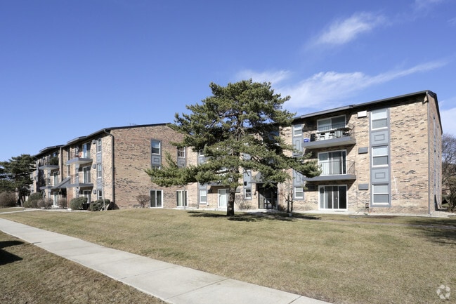
7451 W 159Th St
27-24-200-005-0000
Bremen Towne Estates
Apartment
Cook
X
Illinois
17031C0706J
7.05 AC
2023
Southwest Cook County
2024
Chicago
824123
Chicago-Naperville-Elgin, IL-IN-WI
208,523 SF
DEMOGRAPHICS near 7451 W 159Th St
1 Mile
3 Mile
5 Mile
2024 Total Population
13,511
90,068
193,588
2029 Population
13,043
87,198
188,579
Pop Growth 2024-2029
(3.46%)
(3.19%)
(2.59%)
Average Age
43
42
43
2024 Total Households
5,554
34,572
74,770
HH Growth 2024-2029
(3.76%)
(3.49%)
(2.86%)
Median Household Inc
$72,773
$86,296
$85,475
Avg Household Size
2.40
2.50
2.50
2024 Avg HH Vehicles
2.00
2.00
2.00
Median Home Value
$245,311
$260,539
$264,486
Median Year Built
1978
1980
1981
Nearby Places
Map Layers
Map Styles
 Street
 Aerial
- Restaurants
- Banks
- Shops
- Fitness
- Groceries
PUBLIC TRANSPORTATION
COMMUTER RAIL
Tinley Park Station (Rock Island District Line - Northeast Illinois Regional Commuter Railroad (Metra))
DRIVE
WALK
Distance
Tinley Park Station (Rock Island District Line - Northeast Illinois Regional Commuter Railroad (Metra))
6 min
2.7 mi
Tinley Park - 80Th Avenue Station (Rock Island District Line - Northeast Illinois Regional Commuter Railroad (Metra))
DRIVE
WALK
Distance
Tinley Park - 80Th Avenue Station (Rock Island District Line - Northeast Illinois Regional Commuter Railroad (Metra))
10 min
4.6 mi
AIRPORT
Chicago Midway International
DRIVE
WALK
Distance
Chicago Midway International
27 min
16.1 mi
Chicago O'Hare International
DRIVE
WALK
Distance
Chicago O'Hare International
50 min
34.9 mi
Freight Ports
Port Milwaukee
DRIVE
WALK
Distance
Port Milwaukee
131 min
106.7 mi
Nearby Properties
Address
Land Use
TOTAL SIZE
Lot Size
Zoning
Address
Land Use
TOTAL SIZE
Lot Size
Zoning
673,462 SF
41.34 AC
Address
Land Use
TOTAL SIZE
Lot Size
Zoning
298,700 SF
Address
Land Use
TOTAL SIZE
Lot Size
Zoning
266,729 SF
20.64 AC
Address
Land Use
TOTAL SIZE
Lot Size
Zoning
188,930 SF
9.40 AC
Address
Land Use
TOTAL SIZE
Lot Size
Zoning
Address
Land Use
TOTAL SIZE
Lot Size
Zoning
216,735 SF
11.33 AC
Address
Land Use
TOTAL SIZE
Lot Size
Zoning
103,110 SF
9.12 AC
Address
Land Use
TOTAL SIZE
Lot Size
Zoning
67,394 SF
6.72 AC
Address
Land Use
TOTAL SIZE
Lot Size
Zoning
6.16 AC
Address
Land Use
TOTAL SIZE
Lot Size
Zoning
Address
Land Use
TOTAL SIZE
Lot Size
Zoning
454,002 SF
10.50 AC
Address
Land Use
TOTAL SIZE
Lot Size
Zoning
160,014 SF
13.04 AC
Address
Land Use
TOTAL SIZE
Lot Size
Zoning
135,849 SF
12.77 AC
Address
Land Use
TOTAL SIZE
Lot Size
Zoning
132,193 SF
16.49 AC
Address
Land Use
TOTAL SIZE
Lot Size
Zoning
Address
Land Use
TOTAL SIZE
Lot Size
Zoning
280,313 SF
12.75 AC
Address
Land Use
TOTAL SIZE
Lot Size
Zoning
122,846 SF
17.42 AC
Address
Land Use
TOTAL SIZE
Lot Size
Zoning
114,484 SF
14.88 AC
Address
Land Use
TOTAL SIZE
Lot Size
Zoning
108,890 SF
10.01 AC
Address
Land Use
TOTAL SIZE
Lot Size
Zoning
176,762 SF
6.43 AC
Address
Land Use
TOTAL SIZE
Lot Size
Zoning
273,000 SF
20.69 AC
Address
Land Use
TOTAL SIZE
Lot Size
Zoning
132,808 SF
15.97 AC
Address
Land Use
TOTAL SIZE
Lot Size
Zoning
203,359 SF
12.56 AC
Address
Land Use
TOTAL SIZE
Lot Size
Zoning
74,992 SF
3.62 AC
Address
Land Use
TOTAL SIZE
Lot Size
Zoning
17.50 AC
Address
Land Use
TOTAL SIZE
Lot Size
Zoning
47,125 SF
5.85 AC
Address
Land Use
TOTAL SIZE
Lot Size
Zoning
124,846 SF
Address
Land Use
TOTAL SIZE
Lot Size
Zoning
110,590 SF
10.30 AC
Address
Land Use
TOTAL SIZE
Lot Size
Zoning
92,955 SF
12.33 AC
The World's #1 Commercial Real Estate Marketplace
Connect with us
© 2025 CoStar Group
The information above has been obtained from sources believed reliable. While we do not doubt its accuracy we have not verified it and make no guarantee, warranty or representation about it. It is your responsibility to independently confirm its accuracy and completeness. Any projections, opinions, assumptions, or estimates used are for example only and do not represent the current or future performance of the property. The value of this transaction to you depends on tax and other factors which should be evaluated by your tax, financial, and legal advisors. You and your advisors should conduct a careful, independent investigation of the property to determine to your satisfaction the suitability of the property for your needs.