Property Record
7457 Lewis Rd, Olmsted Twp, OH 44138

NEARBY LISTINGS FOR SALE OR LEASE
-
-
View all Olmsted Twp listings for sale on LoopNet.com
Property Detail
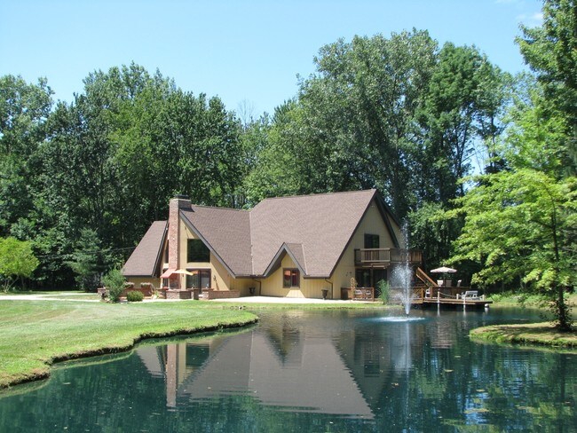
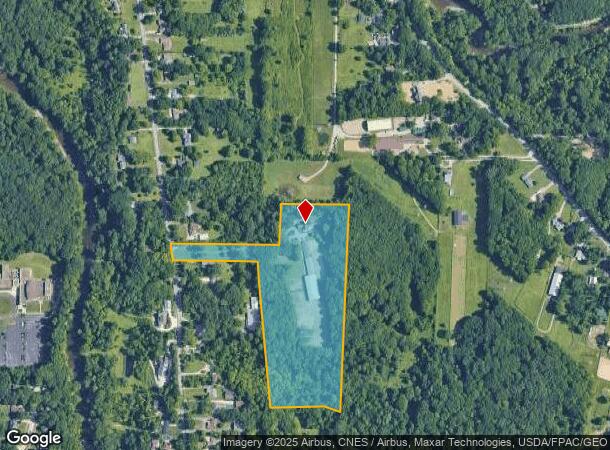
7457 Lewis Rd
Cleveland-Elyria, OH
Np Est
261-09-031
5 TR7 SP 605.81 NP EST 101FF
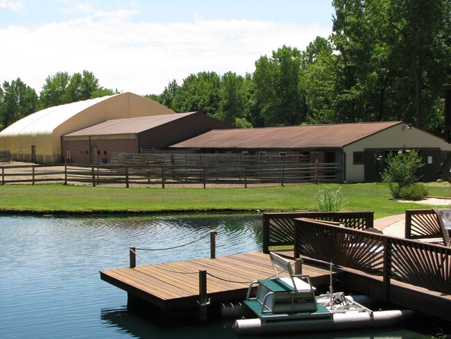
Livestock
Cuyahoga
X
Ohio
39035C0144E
5
2024
13.78 AC
2024
Southwest
190502
Cleveland
4,198 SF
DEMOGRAPHICS near 7457 Lewis Rd
1 Mile
3 Mile
5 Mile
2024 Total Population
2,680
53,235
155,016
2029 Population
2,592
51,819
151,299
Pop Growth 2024-2029
(3.28%)
(2.66%)
(2.40%)
Average Age
43
43
44
2024 Total Households
1,091
22,922
65,544
HH Growth 2024-2029
(3.39%)
(2.82%)
(2.60%)
Median Household Inc
$90,701
$68,205
$75,593
Avg Household Size
2.40
2.20
2.30
2024 Avg HH Vehicles
2.00
2.00
2.00
Median Home Value
$225,731
$181,623
$191,346
Median Year Built
1986
1967
1967
Nearby Places
Map Layers
Map Styles
 Street
 Aerial
- Restaurants
- Banks
- Shops
- Fitness
- Groceries
PUBLIC TRANSPORTATION
AIRPORT
Cleveland-Hopkins International
DRIVE
WALK
Distance
Cleveland-Hopkins International
14 min
5.2 mi
Freight Ports
Port of Toledo
DRIVE
WALK
Distance
Port of Toledo
123 min
101.4 mi
Nearby Properties
Address
Land Use
TOTAL SIZE
Lot Size
Zoning
Address
Land Use
TOTAL SIZE
Lot Size
Zoning
748.88 AC
GI
Address
Land Use
TOTAL SIZE
Lot Size
Zoning
1,669,041 SF
169.42 AC
U6
Address
Land Use
TOTAL SIZE
Lot Size
Zoning
754.68 AC
GI
Address
Land Use
TOTAL SIZE
Lot Size
Zoning
526.33 AC
GI
Address
Land Use
TOTAL SIZE
Lot Size
Zoning
1,514 SF
23.65 AC
RSF-B
Address
Land Use
TOTAL SIZE
Lot Size
Zoning
327,732 SF
57.22 AC
1F
Address
Land Use
TOTAL SIZE
Lot Size
Zoning
657,013 SF
48.88 AC
SI
Address
Land Use
TOTAL SIZE
Lot Size
Zoning
289,215 SF
20.56 AC
RSF-B
Address
Land Use
TOTAL SIZE
Lot Size
Zoning
457,220 SF
41.84 AC
CRG
Address
Land Use
TOTAL SIZE
Lot Size
Zoning
633,719 SF
17.16 AC
CRG
Address
Land Use
TOTAL SIZE
Lot Size
Zoning
278,056 SF
42.71 AC
R-40
Address
Land Use
TOTAL SIZE
Lot Size
Zoning
299,114 SF
23.65 AC
RSF-B
Address
Land Use
TOTAL SIZE
Lot Size
Zoning
195,990 SF
46.88 AC
RMF-A
Address
Land Use
TOTAL SIZE
Lot Size
Zoning
1,391,445 SF
136.05 AC
GI
Address
Land Use
TOTAL SIZE
Lot Size
Zoning
3.53 AC
SI
Address
Land Use
TOTAL SIZE
Lot Size
Zoning
14.60 AC
1F-4
Address
Land Use
TOTAL SIZE
Lot Size
Zoning
64,528 SF
17.67 AC
1F-4
Address
Land Use
TOTAL SIZE
Lot Size
Zoning
209,822 SF
26.92 AC
R-40
Address
Land Use
TOTAL SIZE
Lot Size
Zoning
166,104 SF
4.70 AC
CC
Address
Land Use
TOTAL SIZE
Lot Size
Zoning
24.55 AC
GI
Address
Land Use
TOTAL SIZE
Lot Size
Zoning
334,360 SF
8.22 AC
MF-HD
Address
Land Use
TOTAL SIZE
Lot Size
Zoning
130,030 SF
5.69 AC
RMF-A
Address
Land Use
TOTAL SIZE
Lot Size
Zoning
37.26 AC
SI
Address
Land Use
TOTAL SIZE
Lot Size
Zoning
112,629 SF
9.62 AC
RSF-B
Address
Land Use
TOTAL SIZE
Lot Size
Zoning
59,296 SF
7.08 AC
CC
Address
Land Use
TOTAL SIZE
Lot Size
Zoning
68,600 SF
58.22 AC
U6
Address
Land Use
TOTAL SIZE
Lot Size
Zoning
19,614 SF
353.71 AC
1F-4
Address
Land Use
TOTAL SIZE
Lot Size
Zoning
185,847 SF
17.72 AC
CRG
Address
Land Use
TOTAL SIZE
Lot Size
Zoning
163,501 SF
9.88 AC
CRG
Address
Land Use
TOTAL SIZE
Lot Size
Zoning
141,245 SF
8.90 AC
1F1
The World's #1 Commercial Real Estate Marketplace
Connect with us
© 2025 CoStar Group
The information above has been obtained from sources believed reliable. While we do not doubt its accuracy we have not verified it and make no guarantee, warranty or representation about it. It is your responsibility to independently confirm its accuracy and completeness. Any projections, opinions, assumptions, or estimates used are for example only and do not represent the current or future performance of the property. The value of this transaction to you depends on tax and other factors which should be evaluated by your tax, financial, and legal advisors. You and your advisors should conduct a careful, independent investigation of the property to determine to your satisfaction the suitability of the property for your needs.