Property Record
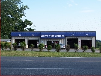
746 Jamestown Rd, Morganton, NC 28655

Property Detail
746 Jamestown Rd
39840
746 JAMESTOWN RD MORGANTON, NC 28655
Autorepair
Burke
HIGH INTEN
North Carolina
B and X Area of moderate flood hazard, usually the area between the limits of the 100-year and 500-year floods.
1.14 AC
2025
Burke County
2025
Charlotte
021400
Hickory-Lenoir-Morganton, NC
4,800 SF
NEARBY LISTINGS FOR SALE OR LEASE
-
-
View all Morganton listings for sale on LoopNet.com
DEMOGRAPHICS near 746 Jamestown Rd
1 mile
3 mile
5 mile
2025 Total Population
1,068
12,378
34,498
2030 Population
1,095
12,455
34,891
Pop Growth 2025-2030
+ 2.53%
+ 0.62%
+ 1.14%
Average Age
42
43
43
2025 Total Households
449
5,019
13,674
HH Growth 2025-2030
+ 2.67%
+ 0.72%
+ 1.27%
Median Household Inc
$41,250
$55,038
$51,880
Avg Household Size
2.20
2.40
2.40
2025 Avg HH Vehicles
2.00
2.00
2.00
Median Home Value
$243,478
$244,909
$227,548
Median Year Built
1975
1973
1977
Nearby Places
Map Layers
Map Styles
 Street
 Aerial
Transit
 Traffic
 Biking
Places
Listings with unknown addresses are not visible on the map
- Restaurants
- Banks
- Shops
- Fitness
- Groceries
SALE & LEASE HISTORY
LISTING DATE
SALE/LEASE

Dec 19, 2023
For Sale
Dec 05, 2023
For Sale
Nearby Properties
Address
Land Use
TOTAL SIZE
Lot Size
Zoning
Address
Land Use
TOTAL SIZE
Lot Size
Zoning
MEDIUM INT
Address
Land Use
TOTAL SIZE
Lot Size
Zoning
23,970 SF
33.98 AC
CONDITIONA
Address
Land Use
TOTAL SIZE
Lot Size
Zoning
MEDIUM INT
Address
Land Use
TOTAL SIZE
Lot Size
Zoning
OFFICE INS
Address
Land Use
TOTAL SIZE
Lot Size
Zoning
185,929 SF
32.01 AC
CONDITIONA
Address
Land Use
TOTAL SIZE
Lot Size
Zoning
73,872 SF
LOW INTENS
Address
Land Use
TOTAL SIZE
Lot Size
Zoning
6,052 SF
13.04 AC
MEDIUM INT
Address
Land Use
TOTAL SIZE
Lot Size
Zoning
299,860 SF
39.81 AC
EXCLUSIVE
Address
Land Use
TOTAL SIZE
Lot Size
Zoning
2,160 SF
12.81 AC
MEDIUM INT
Address
Land Use
TOTAL SIZE
Lot Size
Zoning
135,387 SF
9.95 AC
HIGH INTEN
Address
Land Use
TOTAL SIZE
Lot Size
Zoning
510,924 SF
138.59 AC
EXCLUSIVE
Address
Land Use
TOTAL SIZE
Lot Size
Zoning
25,986 SF
16.78 AC
HIGH INTEN
Address
Land Use
TOTAL SIZE
Lot Size
Zoning
58,998 SF
LOW INTENS
Address
Land Use
TOTAL SIZE
Lot Size
Zoning
40,056 SF
13.80 AC
CONDITIONA
Address
Land Use
TOTAL SIZE
Lot Size
Zoning
65,175 SF
13.48 AC
CONDITIONA
Address
Land Use
TOTAL SIZE
Lot Size
Zoning
20.08 AC
MEDIUM INT
Address
Land Use
TOTAL SIZE
Lot Size
Zoning
109,902 SF
10.97 AC
EXC IND DI
Address
Land Use
TOTAL SIZE
Lot Size
Zoning
87,949 SF
7.95 AC
HIGH INTEN
Address
Land Use
TOTAL SIZE
Lot Size
Zoning
82,601 SF
11.17 AC
HIGH INTEN
Address
Land Use
TOTAL SIZE
Lot Size
Zoning
47,801 SF
4.16 AC
HIGH INTEN
Address
Land Use
TOTAL SIZE
Lot Size
Zoning
10,139 SF
RESIDENTIA
Address
Land Use
TOTAL SIZE
Lot Size
Zoning
13,132 SF
1.93 AC
HIGH INTEN
Address
Land Use
TOTAL SIZE
Lot Size
Zoning
3,240 SF
70 AC
EXCLUSIVE
Address
Land Use
TOTAL SIZE
Lot Size
Zoning
41,092 SF
4.40 AC
HIGH INTEN
Address
Land Use
TOTAL SIZE
Lot Size
Zoning
7,847 SF
1.87 AC
CONDITIONA
Address
Land Use
TOTAL SIZE
Lot Size
Zoning
33,758 SF
1.81 AC
HIGH INTEN
Address
Land Use
TOTAL SIZE
Lot Size
Zoning
37,084 SF
5.07 AC
HIGH INTEN
Address
Land Use
TOTAL SIZE
Lot Size
Zoning
12,160 SF
LOW INTENS
Address
Land Use
TOTAL SIZE
Lot Size
Zoning
38,508 SF
1.90 AC
HIGH INTEN
Address
Land Use
TOTAL SIZE
Lot Size
Zoning
1,645 SF
4.89 AC
HIGH INTEN
The World's #1 Commercial Real Estate Marketplace
Connect with us
© 2026 CoStar Group
The information above has been obtained from sources believed reliable. While we do not doubt its accuracy we have not verified it and make no guarantee, warranty or representation about it. It is your responsibility to independently confirm its accuracy and completeness. Any projections, opinions, assumptions, or estimates used are for example only and do not represent the current or future performance of the property. The value of this transaction to you depends on tax and other factors which should be evaluated by your tax, financial, and legal advisors. You and your advisors should conduct a careful, independent investigation of the property to determine to your satisfaction the suitability of the property for your needs.