Property Record
746 Klockner Rd, Trenton, NJ 08619
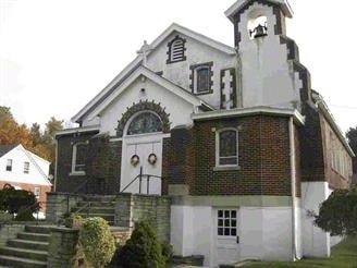

Property Detail
746 Klockner Rd
03-01656-0000-00058
48,49,51,52,55,00108-
Religious
Mercer
R10
New Jersey
C and X Area of minimal flood hazard, usually depicted on FIRMs as above the 500-year flood level.
58
0
3.63 AC
2025
Trenton
002902
Northern New Jersey
1,528 SF
Trenton-Princeton, NJ
NEARBY LISTINGS FOR SALE OR LEASE
DEMOGRAPHICS near 746 Klockner Rd
1 mile
3 mile
5 mile
2025 Total Population
8,195
128,798
259,181
2030 Population
8,342
132,032
266,959
Pop Growth 2025-2030
+ 1.79%
+ 2.51%
+ 3.00%
Average Age
41
39
40
2025 Total Households
3,153
46,705
95,750
HH Growth 2025-2030
+ 1.97%
+ 2.74%
+ 3.22%
Median Household Inc
$88,447
$77,925
$79,119
Avg Household Size
2.50
2.70
2.60
2025 Avg HH Vehicles
2.00
2.00
2.00
Median Home Value
$332,107
$308,143
$319,482
Median Year Built
1958
1955
1958
Nearby Places
Map Layers
Map Styles
 Street
 Aerial
Layers
 Traffic
 Biking
Places
Listings with unknown addresses are not visible on the map
- Restaurants
- Banks
- Shops
- Fitness
- Groceries
PUBLIC TRANSPORTATION
COMMUTER RAIL
Hamilton (Northeast Corridor Line - NJ Transit Commuter Rail (NJ Transit))
Drive
Walk
Distance
Hamilton (Northeast Corridor Line - NJ Transit Commuter Rail (NJ Transit))
5 min
1.6 mi
Drive
Walk
Distance
8 min
3.5 mi
AIRPORT
Trenton Mercer
Drive
Walk
Distance
Trenton Mercer
18 min
8.3 mi
Philadelphia International
Drive
Walk
Distance
Philadelphia International
66 min
49.4 mi
Freight Ports
Port of Philadelphia
Drive
Walk
Distance
Port of Philadelphia
50 min
32.6 mi
Nearby Properties
Address
Land Use
TOTAL SIZE
Lot Size
Zoning
Address
Land Use
TOTAL SIZE
Lot Size
Zoning
Address
Land Use
TOTAL SIZE
Lot Size
Zoning
879,376 SF
2.54 AC
BA
Address
Land Use
TOTAL SIZE
Lot Size
Zoning
5.38 AC
MU
Address
Land Use
TOTAL SIZE
Lot Size
Zoning
Address
Land Use
TOTAL SIZE
Lot Size
Zoning
35.83 AC
RB
Address
Land Use
TOTAL SIZE
Lot Size
Zoning
56.45 AC
EGI
Address
Land Use
TOTAL SIZE
Lot Size
Zoning
161,080 SF
2.21 AC
BA
Address
Land Use
TOTAL SIZE
Lot Size
Zoning
18.33 AC
Address
Land Use
TOTAL SIZE
Lot Size
Zoning
2,920 SF
17.84 AC
HC
Address
Land Use
TOTAL SIZE
Lot Size
Zoning
27,776 SF
21.19 AC
B-H
Address
Land Use
TOTAL SIZE
Lot Size
Zoning
2,925 SF
46.34 AC
Address
Land Use
TOTAL SIZE
Lot Size
Zoning
44.83 AC
I
Address
Land Use
TOTAL SIZE
Lot Size
Zoning
10.29 AC
RB
Address
Land Use
TOTAL SIZE
Lot Size
Zoning
69.56 AC
EGI
Address
Land Use
TOTAL SIZE
Lot Size
Zoning
21.17 AC
I
Address
Land Use
TOTAL SIZE
Lot Size
Zoning
4.07 AC
MU
Address
Land Use
TOTAL SIZE
Lot Size
Zoning
16.86 AC
EG1
Address
Land Use
TOTAL SIZE
Lot Size
Zoning
112,840 SF
Address
Land Use
TOTAL SIZE
Lot Size
Zoning
27.50 AC
R7
Address
Land Use
TOTAL SIZE
Lot Size
Zoning
120,120 SF
0.90 AC
BA
Address
Land Use
TOTAL SIZE
Lot Size
Zoning
Address
Land Use
TOTAL SIZE
Lot Size
Zoning
75,000 SF
3.08 AC
BH
Address
Land Use
TOTAL SIZE
Lot Size
Zoning
91,550 SF
5.35 AC
IA
Address
Land Use
TOTAL SIZE
Lot Size
Zoning
6.79 AC
R7
Address
Land Use
TOTAL SIZE
Lot Size
Zoning
47.84 AC
HC
Address
Land Use
TOTAL SIZE
Lot Size
Zoning
15.80 AC
C
Address
Land Use
TOTAL SIZE
Lot Size
Zoning
43,608 SF
0.80 AC
BB
Address
Land Use
TOTAL SIZE
Lot Size
Zoning
173,385 SF
1.78 AC
MU
Address
Land Use
TOTAL SIZE
Lot Size
Zoning
156,128 SF
6.33 AC
RB
Address
Land Use
TOTAL SIZE
Lot Size
Zoning
43,156 SF
9.17 AC
The World's #1 Commercial Real Estate Marketplace
Connect with us
© 2026 CoStar Group
The information above has been obtained from sources believed reliable. While we do not doubt its accuracy we have not verified it and make no guarantee, warranty or representation about it. It is your responsibility to independently confirm its accuracy and completeness. Any projections, opinions, assumptions, or estimates used are for example only and do not represent the current or future performance of the property. The value of this transaction to you depends on tax and other factors which should be evaluated by your tax, financial, and legal advisors. You and your advisors should conduct a careful, independent investigation of the property to determine to your satisfaction the suitability of the property for your needs.