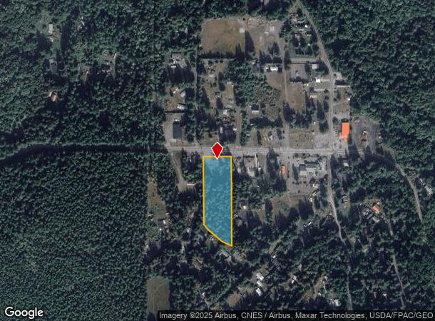
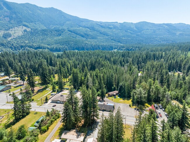
Property Record
7461 Mt Baker Hwy, Deming, WA 98244

This Property Is For Sale
NEARBY LISTINGS FOR SALE OR LEASE
Property Detail
7461 Mt Baker Hwy
400630-178099-0000
TR IN SE SW DAF-BEG AT NE COR OF SE SW-TH N 87 DEG 5244 W ALG NLY LI THEREOF 730 FT-TH S 02 DEG 0716 W 43.68 FT TO SLY R/W LI OF MT BAKER HWY AS IT IS NOW CONSTRUCTED SD PT BEING POB-TH N 87 DEG 0913 W 224.83 FT ALG SD SLY R/W LI TO NE COR OF TR DESC
Restaurantbuilding
Whatcom
X
Washington
53073C0790E
3 AC
2025
Bellingham/Northwest
2025
Other Market Areas
010101
Bellingham, WA
3,398 SF
DEMOGRAPHICS near 7461 Mt Baker Hwy
1 Mile
3 Mile
5 Mile
2024 Total Population
261
1,606
5,059
2029 Population
272
1,677
5,338
Pop Growth 2024-2029
+ 4.21%
+ 4.42%
+ 5.51%
Average Age
43
42
40
2024 Total Households
104
637
1,920
HH Growth 2024-2029
+ 3.85%
+ 4.40%
+ 5.42%
Median Household Inc
$49,999
$42,687
$44,517
Avg Household Size
2.50
2.50
2.50
2024 Avg HH Vehicles
3.00
3.00
2.00
Median Home Value
$436,000
$369,230
$224,545
Median Year Built
1979
1984
1989
Nearby Places
Map Layers
Map Styles
 Street
 Aerial
- Restaurants
- Banks
- Shops
- Fitness
- Groceries
PUBLIC TRANSPORTATION
AIRPORT
Abbotsford International
DRIVE
WALK
Distance
Abbotsford International
39 min
22.5 mi
Bellingham International
DRIVE
WALK
Distance
Bellingham International
45 min
29.7 mi
Freight Ports
Port of Bellingham, WA
DRIVE
WALK
Distance
Port of Bellingham, WA
44 min
28.7 mi
Nearby Properties
Address
Land Use
TOTAL SIZE
Lot Size
Zoning
Address
Land Use
TOTAL SIZE
Lot Size
Zoning
45,126 SF
171.66 AC
R5A
Address
Land Use
TOTAL SIZE
Lot Size
Zoning
56,086 SF
21.57 AC
R10A
Address
Land Use
TOTAL SIZE
Lot Size
Zoning
41,676 SF
42 AC
RF
Address
Land Use
TOTAL SIZE
Lot Size
Zoning
4,636 SF
8.51 AC
STC
Address
Land Use
TOTAL SIZE
Lot Size
Zoning
7,000 SF
4.07 AC
STC
Address
Land Use
TOTAL SIZE
Lot Size
Zoning
8,724 SF
2.08 AC
STC
Address
Land Use
TOTAL SIZE
Lot Size
Zoning
3,627 SF
33.16 AC
R10A
Address
Land Use
TOTAL SIZE
Lot Size
Zoning
7,592 SF
20 AC
CF
Address
Land Use
TOTAL SIZE
Lot Size
Zoning
4,524 SF
85.62 AC
R10A
Address
Land Use
TOTAL SIZE
Lot Size
Zoning
3,849 SF
9.57 AC
R10A
Address
Land Use
TOTAL SIZE
Lot Size
Zoning
10,180 SF
0.69 AC
STC
Address
Land Use
TOTAL SIZE
Lot Size
Zoning
3,400 SF
38.18 AC
RF
Address
Land Use
TOTAL SIZE
Lot Size
Zoning
5,120 SF
2.36 AC
STC
Address
Land Use
TOTAL SIZE
Lot Size
Zoning
3,045 SF
22.44 AC
R10A
Address
Land Use
TOTAL SIZE
Lot Size
Zoning
3,120 SF
2.25 AC
STC
Address
Land Use
TOTAL SIZE
Lot Size
Zoning
4,748 SF
1.39 AC
STC
Address
Land Use
TOTAL SIZE
Lot Size
Zoning
1,200 SF
5 AC
R10A
Address
Land Use
TOTAL SIZE
Lot Size
Zoning
2,861 SF
24.54 AC
RF
Address
Land Use
TOTAL SIZE
Lot Size
Zoning
3,603 SF
5 AC
R10A
Address
Land Use
TOTAL SIZE
Lot Size
Zoning
8,200 SF
3.04 AC
STC
Address
Land Use
TOTAL SIZE
Lot Size
Zoning
14.63 AC
R10A
Address
Land Use
TOTAL SIZE
Lot Size
Zoning
31.04 AC
R10A
Address
Land Use
TOTAL SIZE
Lot Size
Zoning
573.01 AC
CF
Address
Land Use
TOTAL SIZE
Lot Size
Zoning
2,750 SF
34.54 AC
RF
Address
Land Use
TOTAL SIZE
Lot Size
Zoning
13,712 SF
232.05 AC
RF
Address
Land Use
TOTAL SIZE
Lot Size
Zoning
1,644 SF
20.42 AC
RF
Address
Land Use
TOTAL SIZE
Lot Size
Zoning
1,738 SF
20.25 AC
RF
Address
Land Use
TOTAL SIZE
Lot Size
Zoning
520 AC
CF
Address
Land Use
TOTAL SIZE
Lot Size
Zoning
510.64 AC
CF
The World's #1 Commercial Real Estate Marketplace
Connect with us
© 2026 CoStar Group
The information above has been obtained from sources believed reliable. While we do not doubt its accuracy we have not verified it and make no guarantee, warranty or representation about it. It is your responsibility to independently confirm its accuracy and completeness. Any projections, opinions, assumptions, or estimates used are for example only and do not represent the current or future performance of the property. The value of this transaction to you depends on tax and other factors which should be evaluated by your tax, financial, and legal advisors. You and your advisors should conduct a careful, independent investigation of the property to determine to your satisfaction the suitability of the property for your needs.