Property Record
7461 Sw Lost River Rd, Stuart, FL 34997
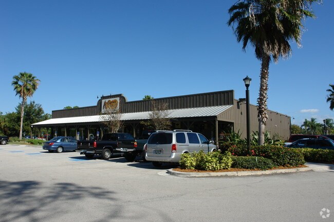

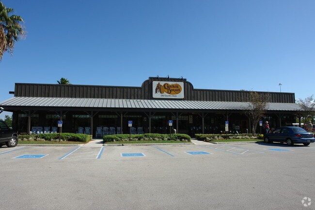
Property Detail
7461 Sw Lost River Rd
05-39-41-003-000-00040-0
LOT 4 PLAT III - NINETY FIVE RIVERSIDE PUD (PB 13 PG 77)
Restaurantbuilding
MARTIN
PUDC
Florida
AE The base floodplain where base flood elevations are provided. AE Zones are now used on new format FIRMs instead of A1-A30 Zones.
4
2024
3.84 AC
2025
Martin
001103
Port St Lucie/Fort Pierce
10,538 SF
Port St. Lucie, FL
NEARBY LISTINGS FOR SALE OR LEASE
-
-
View all Stuart listings for sale on LoopNet.com
DEMOGRAPHICS near 7461 Sw Lost River Rd
1 mile
3 mile
5 mile
2025 Total Population
2,898
19,328
66,626
2030 Population
2,990
19,818
68,757
Pop Growth 2025-2030
+ 3.17%
+ 2.54%
+ 3.20%
Average Age
49
47
47
2025 Total Households
1,211
7,784
28,170
HH Growth 2025-2030
+ 2.89%
+ 2.43%
+ 3.14%
Median Household Inc
$98,923
$85,209
$76,040
Avg Household Size
2.30
2.40
2.20
2025 Avg HH Vehicles
2.00
2.00
2.00
Median Home Value
$515,909
$467,069
$419,149
Median Year Built
1993
1993
1988
Nearby Places
Map Layers
Map Styles
 Street
 Aerial
Transit
 Traffic
 Biking
Places
Listings with unknown addresses are not visible on the map
- Restaurants
- Banks
- Shops
- Fitness
- Groceries
PUBLIC TRANSPORTATION
AIRPORT
Palm Beach International
Drive
Walk
Distance
Palm Beach International
45 min
36.2 mi
Nearby Properties
Address
Land Use
TOTAL SIZE
Lot Size
Zoning
Address
Land Use
TOTAL SIZE
Lot Size
Zoning
49.11 AC
Address
Land Use
TOTAL SIZE
Lot Size
Zoning
118,989 SF
12.43 AC
PUDC
Address
Land Use
TOTAL SIZE
Lot Size
Zoning
16.75 AC
Address
Land Use
TOTAL SIZE
Lot Size
Zoning
182,982 SF
28.90 AC
PUDR
Address
Land Use
TOTAL SIZE
Lot Size
Zoning
17.29 AC
Address
Land Use
TOTAL SIZE
Lot Size
Zoning
48,450 SF
7.94 AC
Address
Land Use
TOTAL SIZE
Lot Size
Zoning
106,105 SF
7.41 AC
PUDR
Address
Land Use
TOTAL SIZE
Lot Size
Zoning
102,843 SF
9.03 AC
Address
Land Use
TOTAL SIZE
Lot Size
Zoning
39,801 SF
8.50 AC
LI
Address
Land Use
TOTAL SIZE
Lot Size
Zoning
56,281 SF
28.86 AC
LI
Address
Land Use
TOTAL SIZE
Lot Size
Zoning
50,773 SF
9.40 AC
COR2
Address
Land Use
TOTAL SIZE
Lot Size
Zoning
69,133 SF
6 AC
PUDC
Address
Land Use
TOTAL SIZE
Lot Size
Zoning
63,133 SF
19.65 AC
A1
Address
Land Use
TOTAL SIZE
Lot Size
Zoning
97,783 SF
6.34 AC
LI
Address
Land Use
TOTAL SIZE
Lot Size
Zoning
63,552 SF
17.36 AC
GC
Address
Land Use
TOTAL SIZE
Lot Size
Zoning
63,874 SF
4.39 AC
PUDC
Address
Land Use
TOTAL SIZE
Lot Size
Zoning
190,638 SF
147 AC
A1
Address
Land Use
TOTAL SIZE
Lot Size
Zoning
35,488 SF
9.10 AC
PS1
Address
Land Use
TOTAL SIZE
Lot Size
Zoning
8,630 SF
17.77 AC
PUDC
Address
Land Use
TOTAL SIZE
Lot Size
Zoning
125,339 SF
23.95 AC
PUDR
Address
Land Use
TOTAL SIZE
Lot Size
Zoning
91,356 SF
7.74 AC
PUDC
Address
Land Use
TOTAL SIZE
Lot Size
Zoning
5.52 AC
LI
Address
Land Use
TOTAL SIZE
Lot Size
Zoning
44,712 SF
15.18 AC
PS2
Address
Land Use
TOTAL SIZE
Lot Size
Zoning
47,906 SF
21.36 AC
RE2A
Address
Land Use
TOTAL SIZE
Lot Size
Zoning
39,555 SF
2.47 AC
PUDC
Address
Land Use
TOTAL SIZE
Lot Size
Zoning
54,508 SF
10.97 AC
A1A
Address
Land Use
TOTAL SIZE
Lot Size
Zoning
248.21 AC
A1
Address
Land Use
TOTAL SIZE
Lot Size
Zoning
51,969 SF
16.19 AC
GI
Address
Land Use
TOTAL SIZE
Lot Size
Zoning
2.99 AC
LI
Address
Land Use
TOTAL SIZE
Lot Size
Zoning
27,934 SF
10.68 AC
PUDC
The World's #1 Commercial Real Estate Marketplace
Connect with us
© 2026 CoStar Group
The information above has been obtained from sources believed reliable. While we do not doubt its accuracy we have not verified it and make no guarantee, warranty or representation about it. It is your responsibility to independently confirm its accuracy and completeness. Any projections, opinions, assumptions, or estimates used are for example only and do not represent the current or future performance of the property. The value of this transaction to you depends on tax and other factors which should be evaluated by your tax, financial, and legal advisors. You and your advisors should conduct a careful, independent investigation of the property to determine to your satisfaction the suitability of the property for your needs.