Property Record
747 Hanami Ln Ne, Bainbridge Island, WA 98110
NEARBY LISTINGS FOR SALE OR LEASE
-
-
View all Bainbridge Island listings for sale on LoopNet.com
Property Detail
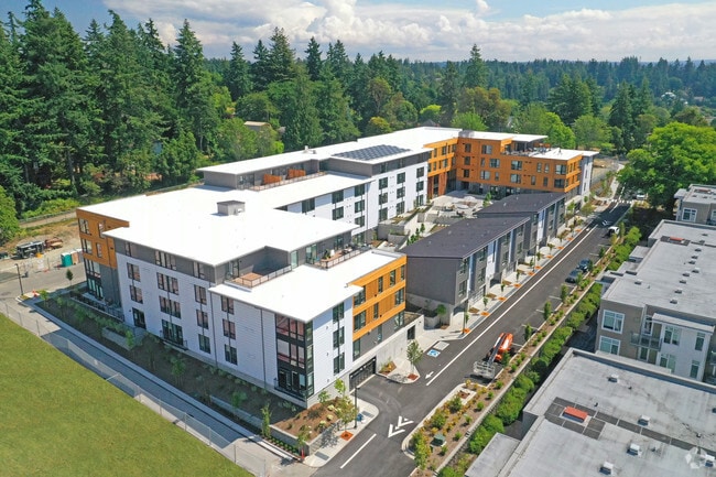
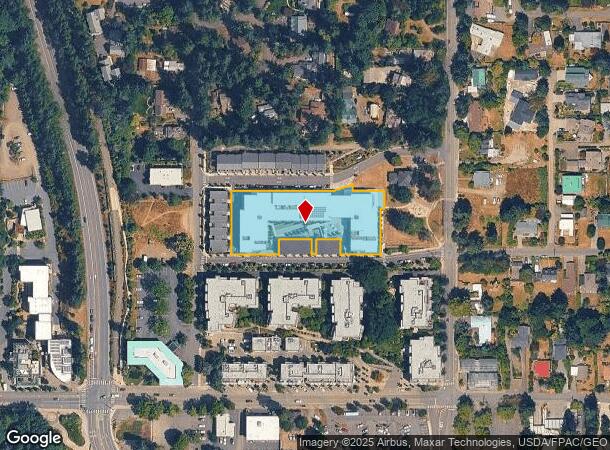
747 Hanami Ln Ne
Bremerton-Silverdale, WA
Landing Which Was Recorded In The Real P
5662-000-026-00-08
LOT 026, THE LANDING, ACCORDING TO THE PLAT RECORDED IN VOLUME 35 OF PLATS, PAGE(S) 56-62, INCLUSIVE, RECORDS OF KITSAP COUNTY, WASHINGTON; SITUATE IN KITSAP COUNTY, WASHINGTON.
Multifamilydwelling
Kitsap
X
Washington
53035C0243F
026
2025
1.40 AC
2026
Wing Point
090902
Bremerton/Silverdale
34,584 SF
DEMOGRAPHICS near 747 Hanami Ln Ne
1 Mile
3 Mile
5 Mile
2024 Total Population
7,120
16,451
35,201
2029 Population
7,243
16,696
35,429
Pop Growth 2024-2029
+ 1.73%
+ 1.49%
+ 0.65%
Average Age
50
48
46
2024 Total Households
3,354
6,934
13,943
HH Growth 2024-2029
+ 1.61%
+ 1.47%
+ 0.69%
Median Household Inc
$131,130
$152,831
$139,246
Avg Household Size
2.10
2.30
2.50
2024 Avg HH Vehicles
1.00
2.00
2.00
Median Home Value
$859,553
$930,237
$848,382
Median Year Built
1993
1990
1984
Nearby Places
Map Layers
Map Styles
 Street
 Aerial
- Restaurants
- Banks
- Shops
- Fitness
- Groceries
PUBLIC TRANSPORTATION
COMMUTER RAIL
King Street (Seattle) Station (Sounder South Line - Central Puget Sound Regional Transit Authority Rail (Link Light Rail/Sounder))
DRIVE
WALK
Distance
King Street (Seattle) Station (Sounder South Line - Central Puget Sound Regional Transit Authority Rail (Link Light Rail/Sounder))
43 min
9.7 mi
AIRPORT
Seattle-Tacoma International
DRIVE
WALK
Distance
Seattle-Tacoma International
64 min
22.0 mi
Seattle Paine Field International
DRIVE
WALK
Distance
Seattle Paine Field International
76 min
33.1 mi
Freight Ports
Port of Seattle
DRIVE
WALK
Distance
Port of Seattle
50 min
12.5 mi
Nearby Properties
Address
Land Use
TOTAL SIZE
Lot Size
Zoning
Address
Land Use
TOTAL SIZE
Lot Size
Zoning
302,902 SF
0.33 AC
NC3-200 (M
Address
Land Use
TOTAL SIZE
Lot Size
Zoning
3,872 SF
252.21 AC
R-0.4
Address
Land Use
TOTAL SIZE
Lot Size
Zoning
77,910 SF
4.62 AC
MAD
Address
Land Use
TOTAL SIZE
Lot Size
Zoning
7.01 AC
CITY
Address
Land Use
TOTAL SIZE
Lot Size
Zoning
74,440 SF
4.36 AC
B/I
Address
Land Use
TOTAL SIZE
Lot Size
Zoning
73,500 SF
4.84 AC
R-2
Address
Land Use
TOTAL SIZE
Lot Size
Zoning
14,536 SF
1.75 AC
MAD
Address
Land Use
TOTAL SIZE
Lot Size
Zoning
29,720 SF
2.75 AC
HS-2
Address
Land Use
TOTAL SIZE
Lot Size
Zoning
52,942 SF
2.07 AC
CORE
Address
Land Use
TOTAL SIZE
Lot Size
Zoning
40,863 SF
3.95 AC
ERICK
Address
Land Use
TOTAL SIZE
Lot Size
Zoning
1,422 SF
1.69 AC
NC
Address
Land Use
TOTAL SIZE
Lot Size
Zoning
26,768 SF
0.46 AC
HS-1
Address
Land Use
TOTAL SIZE
Lot Size
Zoning
43,324 SF
1.54 AC
R-8
Address
Land Use
TOTAL SIZE
Lot Size
Zoning
924 SF
2.36 AC
B/I
Address
Land Use
TOTAL SIZE
Lot Size
Zoning
50,016 SF
1.14 AC
CORE
Address
Land Use
TOTAL SIZE
Lot Size
Zoning
19,826 SF
5.59 AC
R-5
Address
Land Use
TOTAL SIZE
Lot Size
Zoning
46,266 SF
2.22 AC
R-8
Address
Land Use
TOTAL SIZE
Lot Size
Zoning
32,374 SF
4.31 AC
MAD
Address
Land Use
TOTAL SIZE
Lot Size
Zoning
38,262 SF
1.01 AC
MAD
Address
Land Use
TOTAL SIZE
Lot Size
Zoning
22.91 AC
R-0.4
Address
Land Use
TOTAL SIZE
Lot Size
Zoning
38,032 SF
0.90 AC
R-8
Address
Land Use
TOTAL SIZE
Lot Size
Zoning
19,984 SF
7.35 AC
HS-1
Address
Land Use
TOTAL SIZE
Lot Size
Zoning
31,936 SF
2.35 AC
MAD
Address
Land Use
TOTAL SIZE
Lot Size
Zoning
25,695 SF
2.02 AC
B/I
Address
Land Use
TOTAL SIZE
Lot Size
Zoning
460 SF
3.24 AC
R-4.3
Address
Land Use
TOTAL SIZE
Lot Size
Zoning
12,475 SF
0.95 AC
CORE
Address
Land Use
TOTAL SIZE
Lot Size
Zoning
46,699 SF
7.35 AC
HS-1
Address
Land Use
TOTAL SIZE
Lot Size
Zoning
2.10 AC
CITY
Address
Land Use
TOTAL SIZE
Lot Size
Zoning
25,370 SF
0.83 AC
NC
The World's #1 Commercial Real Estate Marketplace
Connect with us
© 2025 CoStar Group
The information above has been obtained from sources believed reliable. While we do not doubt its accuracy we have not verified it and make no guarantee, warranty or representation about it. It is your responsibility to independently confirm its accuracy and completeness. Any projections, opinions, assumptions, or estimates used are for example only and do not represent the current or future performance of the property. The value of this transaction to you depends on tax and other factors which should be evaluated by your tax, financial, and legal advisors. You and your advisors should conduct a careful, independent investigation of the property to determine to your satisfaction the suitability of the property for your needs.