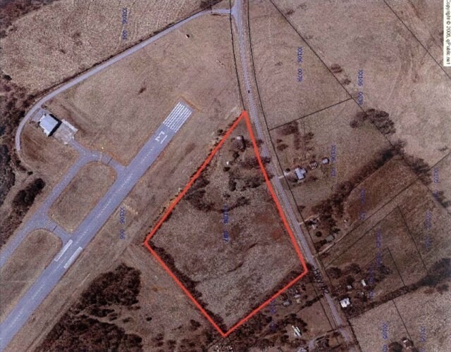
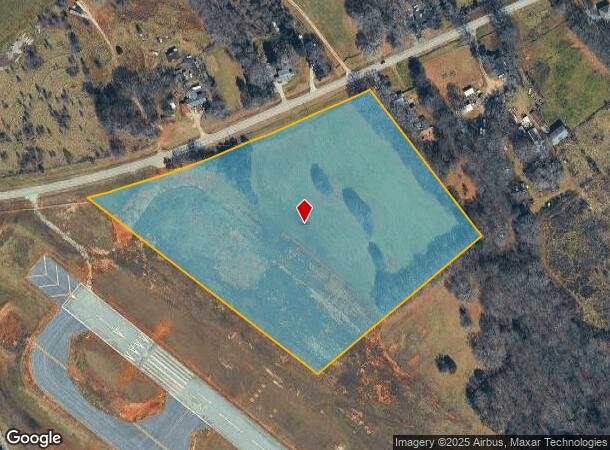
Property Record
747 Highway 82, Winder, GA 30680

NEARBY LISTINGS FOR SALE OR LEASE
Property Detail
747 Highway 82
XX106-007
Walnut Park
Governmentalpublicusegeneral
747 HIGHWAY 82 // EXEMPT
X
Barrow
13013C0135D
Georgia
0
12.20 AC
2024
Barrow County
180301
Atlanta
1,128 SF
Atlanta-Sandy Springs-Roswell, GA
DEMOGRAPHICS near 747 Highway 82
1 Mile
3 Mile
5 Mile
2024 Total Population
1,060
18,985
43,990
2029 Population
1,248
22,255
51,577
Pop Growth 2024-2029
+ 17.74%
+ 17.22%
+ 17.25%
Average Age
38
38
38
2024 Total Households
364
6,756
15,528
HH Growth 2024-2029
+ 17.86%
+ 17.38%
+ 17.38%
Median Household Inc
$60,833
$57,890
$62,808
Avg Household Size
2.90
2.70
2.80
2024 Avg HH Vehicles
2.00
2.00
2.00
Median Home Value
$182,575
$196,297
$205,702
Median Year Built
2002
2000
1999
Nearby Places
Map Layers
Map Styles
 Street
 Aerial
- Restaurants
- Banks
- Shops
- Fitness
- Groceries
SALE & LEASE HISTORY
LISTING DATE
SALE/LEASE

Apr 15, 2017
For Sale
Nearby Properties
Address
Land Use
TOTAL SIZE
Lot Size
Zoning
Address
Land Use
TOTAL SIZE
Lot Size
Zoning
398,490 SF
56.70 AC
M-1
Address
Land Use
TOTAL SIZE
Lot Size
Zoning
275,840 SF
22.10 AC
M-1
Address
Land Use
TOTAL SIZE
Lot Size
Zoning
6,928 SF
358.90 AC
AC
Address
Land Use
TOTAL SIZE
Lot Size
Zoning
27,337 SF
60 AC
M-2
Address
Land Use
TOTAL SIZE
Lot Size
Zoning
20,132 SF
56.30 AC
M-2
Address
Land Use
TOTAL SIZE
Lot Size
Zoning
35,790 SF
69.70 AC
G
Address
Land Use
TOTAL SIZE
Lot Size
Zoning
6,960 SF
46.90 AC
M-2
Address
Land Use
TOTAL SIZE
Lot Size
Zoning
83,937 SF
17.80 AC
B-1
Address
Land Use
TOTAL SIZE
Lot Size
Zoning
107,399 SF
14.30 AC
B-1
Address
Land Use
TOTAL SIZE
Lot Size
Zoning
48,998 SF
15.50 AC
B-1
Address
Land Use
TOTAL SIZE
Lot Size
Zoning
3,462 SF
10.10 AC
G,R-3
Address
Land Use
TOTAL SIZE
Lot Size
Zoning
20,857 SF
39.60 AC
M-1
Address
Land Use
TOTAL SIZE
Lot Size
Zoning
4,210 SF
3.30 AC
G
Address
Land Use
TOTAL SIZE
Lot Size
Zoning
51,753 SF
9.20 AC
B-2,R-3
Address
Land Use
TOTAL SIZE
Lot Size
Zoning
4,405 SF
7.50 AC
B-1,R-1,R-
Address
Land Use
TOTAL SIZE
Lot Size
Zoning
85,290 SF
29.10 AC
C-3
Address
Land Use
TOTAL SIZE
Lot Size
Zoning
20,592 SF
66.10 AC
G
Address
Land Use
TOTAL SIZE
Lot Size
Zoning
30,575 SF
7.30 AC
G,R-1A
Address
Land Use
TOTAL SIZE
Lot Size
Zoning
65.10 AC
PUD
Address
Land Use
TOTAL SIZE
Lot Size
Zoning
50,662 SF
6.20 AC
G
Address
Land Use
TOTAL SIZE
Lot Size
Zoning
7,000 SF
10.70 AC
G
Address
Land Use
TOTAL SIZE
Lot Size
Zoning
40,950 SF
32.90 AC
M-2
Address
Land Use
TOTAL SIZE
Lot Size
Zoning
11,914 SF
6.90 AC
G,R-2,R-3
Address
Land Use
TOTAL SIZE
Lot Size
Zoning
3,800 SF
4.50 AC
R-3
Address
Land Use
TOTAL SIZE
Lot Size
Zoning
38,423 SF
4.10 AC
R-1
Address
Land Use
TOTAL SIZE
Lot Size
Zoning
15,000 SF
7.50 AC
Address
Land Use
TOTAL SIZE
Lot Size
Zoning
10,125 SF
63.60 AC
M-2
Address
Land Use
TOTAL SIZE
Lot Size
Zoning
24,658 SF
3 AC
B-2
Address
Land Use
TOTAL SIZE
Lot Size
Zoning
55,910 SF
3.50 AC
B-1
Address
Land Use
TOTAL SIZE
Lot Size
Zoning
6,498 SF
1.20 AC
B-1
The World's #1 Commercial Real Estate Marketplace
Connect with us
© 2025 CoStar Group
The information above has been obtained from sources believed reliable. While we do not doubt its accuracy we have not verified it and make no guarantee, warranty or representation about it. It is your responsibility to independently confirm its accuracy and completeness. Any projections, opinions, assumptions, or estimates used are for example only and do not represent the current or future performance of the property. The value of this transaction to you depends on tax and other factors which should be evaluated by your tax, financial, and legal advisors. You and your advisors should conduct a careful, independent investigation of the property to determine to your satisfaction the suitability of the property for your needs.