Property Record
7477 Rawsonville Rd, Van Buren Township, MI 48111


NEARBY LISTINGS FOR SALE OR LEASE
Property Detail
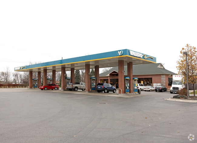
7477 Rawsonville Rd
83-123-99-0001-710
*31H1A1C* THAT PT OF THE SW 1/4 SEC 31 T3S R8E DESC AS BEG AT W1/4 COR SEC 31; TH S 89D 41M 25S E 300.01 FT; TH DUE S 220 FT; TH N 89D 41M 25S W 300 FT; TH DUE N 220.01 FT; TO POB EXC N 60 FT AND W 60 FT THEREOF 0.88 AC - K - 0.88
Conveniencestore
Wayne
X
Michigan
26161C0445E
0001
2025
0.88 AC
2025
Airport District
588300
Detroit
3,943 SF
Detroit-Warren-Dearborn, MI
DEMOGRAPHICS near 7477 Rawsonville Rd
1 Mile
3 Mile
5 Mile
2024 Total Population
2,366
23,759
67,342
2029 Population
2,357
23,518
66,028
Pop Growth 2024-2029
(0.38%)
(1.01%)
(1.95%)
Average Age
41
40
40
2024 Total Households
917
9,957
27,733
HH Growth 2024-2029
(0.55%)
(1.19%)
(2.07%)
Median Household Inc
$67,383
$69,496
$68,686
Avg Household Size
2.50
2.30
2.40
2024 Avg HH Vehicles
2.00
2.00
2.00
Median Home Value
$176,009
$221,402
$213,598
Median Year Built
1989
1985
1979
Nearby Places
Map Layers
Map Styles
 Street
 Aerial
- Restaurants
- Banks
- Shops
- Fitness
- Groceries
PUBLIC TRANSPORTATION
AIRPORT
Detroit Metro Wayne County
DRIVE
WALK
Distance
Detroit Metro Wayne County
21 min
15.0 mi
Freight Ports
Port of Toledo
DRIVE
WALK
Distance
Port of Toledo
70 min
56.6 mi
Nearby Properties
Address
Land Use
TOTAL SIZE
Lot Size
Zoning
Address
Land Use
TOTAL SIZE
Lot Size
Zoning
38,001 SF
177.04 AC
BA
Address
Land Use
TOTAL SIZE
Lot Size
Zoning
11,847 SF
91.35 AC
II
Address
Land Use
TOTAL SIZE
Lot Size
Zoning
97.69 AC
Address
Land Use
TOTAL SIZE
Lot Size
Zoning
206,958 SF
8.33 AC
AP
Address
Land Use
TOTAL SIZE
Lot Size
Zoning
198,549 SF
13.43 AC
RM MULT
Address
Land Use
TOTAL SIZE
Lot Size
Zoning
196,044 SF
18.67 AC
RM MULT
Address
Land Use
TOTAL SIZE
Lot Size
Zoning
1,960 SF
59.97 AC
Address
Land Use
TOTAL SIZE
Lot Size
Zoning
161,042 SF
26.29 AC
II
Address
Land Use
TOTAL SIZE
Lot Size
Zoning
126,711 SF
12.74 AC
Address
Land Use
TOTAL SIZE
Lot Size
Zoning
29,610 SF
9.10 AC
BA
Address
Land Use
TOTAL SIZE
Lot Size
Zoning
134,499 SF
6.20 AC
BA
Address
Land Use
TOTAL SIZE
Lot Size
Zoning
1,744 SF
41.75 AC
BI
Address
Land Use
TOTAL SIZE
Lot Size
Zoning
72,834 SF
4.97 AC
RM MULT
Address
Land Use
TOTAL SIZE
Lot Size
Zoning
1,680 SF
20 AC
II
Address
Land Use
TOTAL SIZE
Lot Size
Zoning
73,239 SF
6.18 AC
RM MULT
Address
Land Use
TOTAL SIZE
Lot Size
Zoning
66,340 SF
6.59 AC
RM MULT
Address
Land Use
TOTAL SIZE
Lot Size
Zoning
54.32 AC
RMH MOB
Address
Land Use
TOTAL SIZE
Lot Size
Zoning
80.11 AC
Address
Land Use
TOTAL SIZE
Lot Size
Zoning
89,778 SF
9.65 AC
C1 GEN
Address
Land Use
TOTAL SIZE
Lot Size
Zoning
36,200 SF
15.23 AC
Address
Land Use
TOTAL SIZE
Lot Size
Zoning
51,840 SF
9.07 AC
Address
Land Use
TOTAL SIZE
Lot Size
Zoning
16,414 SF
7.66 AC
BA
Address
Land Use
TOTAL SIZE
Lot Size
Zoning
4,442 SF
42.38 AC
RMH MOB
Address
Land Use
TOTAL SIZE
Lot Size
Zoning
224,938 SF
19.42 AC
C1 GEN
Address
Land Use
TOTAL SIZE
Lot Size
Zoning
52,644 SF
5.59 AC
RM MULT
Address
Land Use
TOTAL SIZE
Lot Size
Zoning
35,440 SF
12.36 AC
Address
Land Use
TOTAL SIZE
Lot Size
Zoning
6,000 SF
15 AC
DI
Address
Land Use
TOTAL SIZE
Lot Size
Zoning
35.89 AC
RMH MOB
Address
Land Use
TOTAL SIZE
Lot Size
Zoning
20 AC
DI
Address
Land Use
TOTAL SIZE
Lot Size
Zoning
8,580 SF
28.50 AC
The World's #1 Commercial Real Estate Marketplace
Connect with us
© 2026 CoStar Group
The information above has been obtained from sources believed reliable. While we do not doubt its accuracy we have not verified it and make no guarantee, warranty or representation about it. It is your responsibility to independently confirm its accuracy and completeness. Any projections, opinions, assumptions, or estimates used are for example only and do not represent the current or future performance of the property. The value of this transaction to you depends on tax and other factors which should be evaluated by your tax, financial, and legal advisors. You and your advisors should conduct a careful, independent investigation of the property to determine to your satisfaction the suitability of the property for your needs.