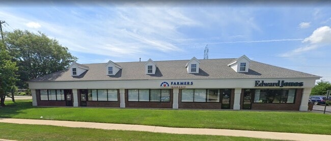
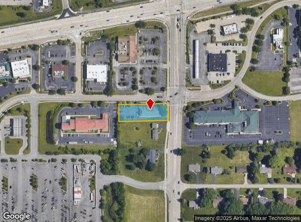
Property Record
7479 Walton St, Rockford, IL 61108
Current Lease Availabilities
NEARBY LISTINGS FOR SALE OR LEASE
Property Detail
7479 Walton St
Rockford, IL
Interstate Commercial Centre
12-23-377-029
REPLAT OF THE RESUB LT 4 INTERSTATE COMMERCIAL CENTRE PT SE1/4 SW1/4 SEC 23-44-2 (EXC ROW BY 2013-1021094) LOT 9
Officebuilding
Winnebago
X
Illinois
17201C0288E
4
2024
0.66 AC
2024
I-39 Corr/Winnebago Cnty
000514
Chicago
5,566 SF
DEMOGRAPHICS near 7479 Walton St
1 Mile
3 Mile
5 Mile
2024 Total Population
4,033
35,936
107,622
2029 Population
4,007
35,473
106,035
Pop Growth 2024-2029
(0.64%)
(1.29%)
(1.47%)
Average Age
47
45
42
2024 Total Households
1,917
14,984
44,604
HH Growth 2024-2029
(0.57%)
(1.25%)
(1.49%)
Median Household Inc
$72,584
$71,070
$63,491
Avg Household Size
2.10
2.30
2.30
2024 Avg HH Vehicles
2.00
2.00
2.00
Median Home Value
$160,248
$169,359
$156,410
Median Year Built
1993
1982
1975
Nearby Places
Map Layers
Map Styles
 Street
 Aerial
- Restaurants
- Banks
- Shops
- Fitness
- Groceries
PUBLIC TRANSPORTATION
AIRPORT
Chicago/Rockford International
DRIVE
WALK
Distance
Chicago/Rockford International
24 min
14.0 mi
Freight Ports
Port Milwaukee
DRIVE
WALK
Distance
Port Milwaukee
105 min
89.4 mi
Nearby Properties
Address
Land Use
TOTAL SIZE
Lot Size
Zoning
Address
Land Use
TOTAL SIZE
Lot Size
Zoning
559,880 SF
56.87 AC
CC
Address
Land Use
TOTAL SIZE
Lot Size
Zoning
177,667 SF
22.14 AC
C3
Address
Land Use
TOTAL SIZE
Lot Size
Zoning
302,569 SF
24.58 AC
C2
Address
Land Use
TOTAL SIZE
Lot Size
Zoning
218,420 SF
33.07 AC
C3
Address
Land Use
TOTAL SIZE
Lot Size
Zoning
169,198 SF
14 AC
C3
Address
Land Use
TOTAL SIZE
Lot Size
Zoning
138,658 SF
12.91 AC
C2
Address
Land Use
TOTAL SIZE
Lot Size
Zoning
195,672 SF
10.63 AC
C3
Address
Land Use
TOTAL SIZE
Lot Size
Zoning
134,779 SF
9.93 AC
C2
Address
Land Use
TOTAL SIZE
Lot Size
Zoning
217,520 SF
13.82 AC
C3
Address
Land Use
TOTAL SIZE
Lot Size
Zoning
79,055 SF
10.89 AC
R4
Address
Land Use
TOTAL SIZE
Lot Size
Zoning
200,666 SF
28.90 AC
IL
Address
Land Use
TOTAL SIZE
Lot Size
Zoning
110,218 SF
8.12 AC
C2
Address
Land Use
TOTAL SIZE
Lot Size
Zoning
160,288 SF
5.70 AC
C3
Address
Land Use
TOTAL SIZE
Lot Size
Zoning
96,130 SF
12.47 AC
R2
Address
Land Use
TOTAL SIZE
Lot Size
Zoning
73,031 SF
10.23 AC
C1
Address
Land Use
TOTAL SIZE
Lot Size
Zoning
70,986 SF
4.33 AC
OF
Address
Land Use
TOTAL SIZE
Lot Size
Zoning
141,752 SF
12.10 AC
C2
Address
Land Use
TOTAL SIZE
Lot Size
Zoning
19,406 SF
10.13 AC
R4
Address
Land Use
TOTAL SIZE
Lot Size
Zoning
128,736 SF
14.64 AC
C2
Address
Land Use
TOTAL SIZE
Lot Size
Zoning
142,140 SF
13.44 AC
C2
Address
Land Use
TOTAL SIZE
Lot Size
Zoning
71,799 SF
4.51 AC
C1
Address
Land Use
TOTAL SIZE
Lot Size
Zoning
63,492 SF
4.92 AC
C1
Address
Land Use
TOTAL SIZE
Lot Size
Zoning
84,569 SF
4 AC
C3
Address
Land Use
TOTAL SIZE
Lot Size
Zoning
79,147 SF
5.08 AC
R3
Address
Land Use
TOTAL SIZE
Lot Size
Zoning
210,007 SF
15.86 AC
C2
Address
Land Use
TOTAL SIZE
Lot Size
Zoning
89,350 SF
9.17 AC
C2
Address
Land Use
TOTAL SIZE
Lot Size
Zoning
77,718 SF
11.12 AC
C2
Address
Land Use
TOTAL SIZE
Lot Size
Zoning
49,832 SF
5.62 AC
C2
Address
Land Use
TOTAL SIZE
Lot Size
Zoning
138,746 SF
11.04 AC
C3
Address
Land Use
TOTAL SIZE
Lot Size
Zoning
63,016 SF
5.48 AC
C1
The World's #1 Commercial Real Estate Marketplace
Connect with us
© 2025 CoStar Group
The information above has been obtained from sources believed reliable. While we do not doubt its accuracy we have not verified it and make no guarantee, warranty or representation about it. It is your responsibility to independently confirm its accuracy and completeness. Any projections, opinions, assumptions, or estimates used are for example only and do not represent the current or future performance of the property. The value of this transaction to you depends on tax and other factors which should be evaluated by your tax, financial, and legal advisors. You and your advisors should conduct a careful, independent investigation of the property to determine to your satisfaction the suitability of the property for your needs.