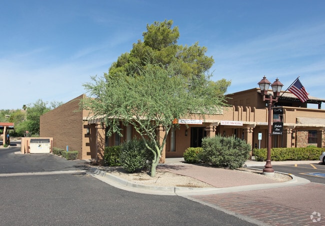
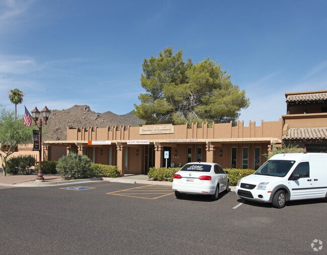
Property Record
748 Easy St, Carefree, AZ 85377

Save to a Folder
{{folder.Name}}
{{folder.ListingIds.length}} Properties
{{folder.ListingIds.length}} Property
Create a New Folder
Property Detail
748 Easy St
216-83-032
CAREFREE ARIZONA MCR 80/27
Officebuilding
Maricopa
C-C
Arizona
C and X Area of minimal flood hazard, usually depicted on FIRMs as above the 500-year flood level.
32
2025
0.25 AC
2025
N Scottsdale/Carefree
030401
Phoenix
5,620 SF
Phoenix-Mesa-Chandler, AZ
NEARBY LISTINGS FOR SALE OR LEASE
DEMOGRAPHICS near 748 Easy St
1 mile
3 mile
5 mile
2025 Total Population
2,291
16,352
38,585
2030 Population
2,452
17,555
41,076
Pop Growth 2025-2030
+ 7.03%
+ 7.36%
+ 6.46%
Average Age
60
59
56
2025 Total Households
1,148
7,745
17,175
HH Growth 2025-2030
+ 7.06%
+ 7.46%
+ 6.79%
Median Household Inc
$139,074
$142,450
$156,845
Avg Household Size
2.00
2.10
2.20
2025 Avg HH Vehicles
2.00
2.00
2.00
Median Home Value
$1,043,345
$1,032,929
$1,021,579
Median Year Built
1989
1997
2000
Nearby Places
Map Layers
Map Styles
 Street
 Aerial
Layers
 Traffic
 Biking
Places
Listings with unknown addresses are not visible on the map
- Restaurants
- Banks
- Shops
- Fitness
- Groceries
PUBLIC TRANSPORTATION
AIRPORT
Phoenix Sky Harbor International
Drive
Walk
Distance
Phoenix Sky Harbor International
51 min
34.0 mi
Freight Ports
Port of San Diego
Drive
Walk
Distance
Port of San Diego
435 min
383.4 mi
SALE & LEASE HISTORY
LISTING DATE
SALE/LEASE

Sep 25, 2016
For Lease
Sep 24, 2016
For Sale
Nearby Properties
Address
Land Use
TOTAL SIZE
Lot Size
Zoning
Address
Land Use
TOTAL SIZE
Lot Size
Zoning
13.01 AC
Address
Land Use
TOTAL SIZE
Lot Size
Zoning
170,385 SF
23.82 AC
C-C
Address
Land Use
TOTAL SIZE
Lot Size
Zoning
140,303 SF
29.18 AC
R-4R
Address
Land Use
TOTAL SIZE
Lot Size
Zoning
123,518 SF
14.92 AC
C-C
Address
Land Use
TOTAL SIZE
Lot Size
Zoning
126,785 SF
17.94 AC
C-G
Address
Land Use
TOTAL SIZE
Lot Size
Zoning
223,188 SF
13.68 AC
RT
Address
Land Use
TOTAL SIZE
Lot Size
Zoning
82,175 SF
8.65 AC
C-C
Address
Land Use
TOTAL SIZE
Lot Size
Zoning
47,830 SF
5.22 AC
R-43
Address
Land Use
TOTAL SIZE
Lot Size
Zoning
58,725 SF
8.32 AC
C-C
Address
Land Use
TOTAL SIZE
Lot Size
Zoning
84,248 SF
6.68 AC
C-C
Address
Land Use
TOTAL SIZE
Lot Size
Zoning
35,734 SF
10.13 AC
R-43
Address
Land Use
TOTAL SIZE
Lot Size
Zoning
32,944 SF
6.89 AC
R-70
Address
Land Use
TOTAL SIZE
Lot Size
Zoning
65,744 SF
2.05 AC
Address
Land Use
TOTAL SIZE
Lot Size
Zoning
21,828 SF
58.46 AC
R-43
Address
Land Use
TOTAL SIZE
Lot Size
Zoning
47,388 SF
4.69 AC
C-C
Address
Land Use
TOTAL SIZE
Lot Size
Zoning
15,261 SF
13.02 AC
R135
Address
Land Use
TOTAL SIZE
Lot Size
Zoning
31,318 SF
5.37 AC
C-C
Address
Land Use
TOTAL SIZE
Lot Size
Zoning
27,058 SF
8.21 AC
O-S
Address
Land Use
TOTAL SIZE
Lot Size
Zoning
2.88 AC
R-43
Address
Land Use
TOTAL SIZE
Lot Size
Zoning
64,796 SF
2.86 AC
C-C
Address
Land Use
TOTAL SIZE
Lot Size
Zoning
29,900 SF
3.18 AC
GC
Address
Land Use
TOTAL SIZE
Lot Size
Zoning
12.46 AC
C-C
Address
Land Use
TOTAL SIZE
Lot Size
Zoning
90,526 SF
32.62 AC
R-190
Address
Land Use
TOTAL SIZE
Lot Size
Zoning
12,832 SF
5.44 AC
RURAL43
Address
Land Use
TOTAL SIZE
Lot Size
Zoning
35,680 SF
5.91 AC
RT
Address
Land Use
TOTAL SIZE
Lot Size
Zoning
9.27 AC
RT
Address
Land Use
TOTAL SIZE
Lot Size
Zoning
29,792 SF
3.42 AC
C-T
Address
Land Use
TOTAL SIZE
Lot Size
Zoning
14,188 SF
2.80 AC
C-C
Address
Land Use
TOTAL SIZE
Lot Size
Zoning
1.10 AC
R35
The World's #1 Commercial Real Estate Marketplace
Connect with us
© 2026 CoStar Group
The information above has been obtained from sources believed reliable. While we do not doubt its accuracy we have not verified it and make no guarantee, warranty or representation about it. It is your responsibility to independently confirm its accuracy and completeness. Any projections, opinions, assumptions, or estimates used are for example only and do not represent the current or future performance of the property. The value of this transaction to you depends on tax and other factors which should be evaluated by your tax, financial, and legal advisors. You and your advisors should conduct a careful, independent investigation of the property to determine to your satisfaction the suitability of the property for your needs.