Property Record
7485 Highway 270, Malvern, AR 72104
NEARBY LISTINGS FOR SALE OR LEASE
-
-
View all Malvern listings for sale on LoopNet.com
Property Detail
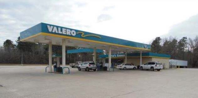
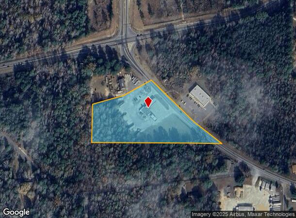
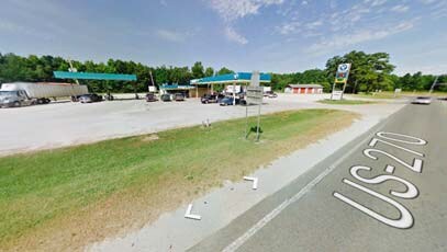
7485 Highway 270
800-01073-106
Perla Annex 2002
Conveniencestore
PT NW SE (CONVENIENCE STORE)
A
Hot Spring
05059C0400C
Arkansas
2025
5.30 AC
2025
Arkansas South Area
020400
Other Market Areas
1,600 SF
Malvern, AR
DEMOGRAPHICS near 7485 Highway 270
1 mile
3 mile
5 mile
2024 Total Population
297
9,542
14,839
2029 Population
297
9,664
15,036
Pop Growth 2024-2029
0.00%
+ 1.28%
+ 1.33%
Average Age
40
40
41
2024 Total Households
121
3,892
5,667
HH Growth 2024-2029
0.00%
+ 1.31%
+ 1.38%
Median Household Inc
$28,970
$35,927
$40,009
Avg Household Size
2.40
2.40
2.40
2024 Avg HH Vehicles
2.00
2.00
2.00
Median Home Value
$93,477
$84,866
$92,610
Median Year Built
1974
1971
1972
Nearby Places
Map Layers
Map Styles
 Street
 Aerial
Transit
 Traffic
 Biking
Places
Listings with unknown addresses are not visible on the map
- Restaurants
- Banks
- Shops
- Fitness
- Groceries
PUBLIC TRANSPORTATION
AIRPORT
Bill and Hillary Clinton Ntl/Adams Field
Drive
Walk
Distance
Bill and Hillary Clinton Ntl/Adams Field
52 min
46.3 mi
SALE & LEASE HISTORY
LISTING DATE
SALE/LEASE

Sep 23, 2016
For Sale
Nearby Properties
Address
Land Use
TOTAL SIZE
Lot Size
Zoning
Address
Land Use
TOTAL SIZE
Lot Size
Zoning
18,360 SF
2.62 AC
Address
Land Use
TOTAL SIZE
Lot Size
Zoning
129,005 SF
64.27 AC
Address
Land Use
TOTAL SIZE
Lot Size
Zoning
91,250 SF
10.35 AC
Address
Land Use
TOTAL SIZE
Lot Size
Zoning
66,368 SF
4.90 AC
Address
Land Use
TOTAL SIZE
Lot Size
Zoning
4,935 SF
25.70 AC
Address
Land Use
TOTAL SIZE
Lot Size
Zoning
36,026 SF
6.95 AC
Address
Land Use
TOTAL SIZE
Lot Size
Zoning
14,476 SF
Address
Land Use
TOTAL SIZE
Lot Size
Zoning
1,098 SF
9.30 AC
Address
Land Use
TOTAL SIZE
Lot Size
Zoning
17,750 SF
1.75 AC
Address
Land Use
TOTAL SIZE
Lot Size
Zoning
19,732 SF
1.43 AC
Address
Land Use
TOTAL SIZE
Lot Size
Zoning
14,466 SF
1.37 AC
Address
Land Use
TOTAL SIZE
Lot Size
Zoning
31,958 SF
2.60 AC
Address
Land Use
TOTAL SIZE
Lot Size
Zoning
102,784 SF
24.45 AC
Address
Land Use
TOTAL SIZE
Lot Size
Zoning
13,496 SF
4.33 AC
Address
Land Use
TOTAL SIZE
Lot Size
Zoning
9,792 SF
0.75 AC
Address
Land Use
TOTAL SIZE
Lot Size
Zoning
26,246 SF
5.13 AC
Address
Land Use
TOTAL SIZE
Lot Size
Zoning
12,409 SF
1.47 AC
Address
Land Use
TOTAL SIZE
Lot Size
Zoning
17,772 SF
1.55 AC
Address
Land Use
TOTAL SIZE
Lot Size
Zoning
101,339 SF
27.50 AC
Address
Land Use
TOTAL SIZE
Lot Size
Zoning
3,574 SF
42.42 AC
Address
Land Use
TOTAL SIZE
Lot Size
Zoning
5,100 SF
20 AC
Address
Land Use
TOTAL SIZE
Lot Size
Zoning
25,931 SF
1 AC
Address
Land Use
TOTAL SIZE
Lot Size
Zoning
8,160 SF
1.43 AC
Address
Land Use
TOTAL SIZE
Lot Size
Zoning
3,528 SF
0.14 AC
Address
Land Use
TOTAL SIZE
Lot Size
Zoning
16,028 SF
3.22 AC
Address
Land Use
TOTAL SIZE
Lot Size
Zoning
6,873 SF
0.50 AC
Address
Land Use
TOTAL SIZE
Lot Size
Zoning
5,691 SF
7 AC
Address
Land Use
TOTAL SIZE
Lot Size
Zoning
5,804 SF
1.12 AC
Address
Land Use
TOTAL SIZE
Lot Size
Zoning
11,186 SF
0.55 AC
Address
Land Use
TOTAL SIZE
Lot Size
Zoning
10,716 SF
1.65 AC
The World's #1 Commercial Real Estate Marketplace
Connect with us
© 2026 CoStar Group
The information above has been obtained from sources believed reliable. While we do not doubt its accuracy we have not verified it and make no guarantee, warranty or representation about it. It is your responsibility to independently confirm its accuracy and completeness. Any projections, opinions, assumptions, or estimates used are for example only and do not represent the current or future performance of the property. The value of this transaction to you depends on tax and other factors which should be evaluated by your tax, financial, and legal advisors. You and your advisors should conduct a careful, independent investigation of the property to determine to your satisfaction the suitability of the property for your needs.