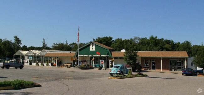
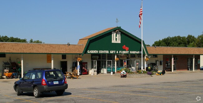
Property Record
749 Colonel Ledyard Hwy, Ledyard, CT 06339
Property Detail
749 Colonel Ledyard Hwy
LEDY-000067-000530-000749
NEW LONDON
Commercialnec
Connecticut
LCV1
749
B and X Area of moderate flood hazard, usually the area between the limits of the 100-year and 500-year floods.
6.45 AC
2025
New London
2025
Hartford
701100
Norwich-New London-Willimantic, CT
NEARBY LISTINGS FOR SALE OR LEASE
-
-
View all Ledyard listings for sale on LoopNet.com
DEMOGRAPHICS near 749 Colonel Ledyard Hwy
1 mile
3 mile
5 mile
2025 Total Population
1,055
11,212
31,479
2030 Population
1,077
11,302
31,789
Pop Growth 2025-2030
+ 2.09%
+ 0.80%
+ 0.98%
Average Age
41
41
41
2025 Total Households
388
4,185
11,487
HH Growth 2025-2030
+ 2.06%
+ 0.67%
+ 0.98%
Median Household Inc
$110,755
$110,685
$97,939
Avg Household Size
2.70
2.70
2.50
2025 Avg HH Vehicles
2.00
2.00
2.00
Median Home Value
$328,151
$317,701
$314,348
Median Year Built
1976
1971
1970
Nearby Places
Map Layers
Map Styles
 Street
 Aerial
Transit
 Traffic
 Biking
Places
Listings with unknown addresses are not visible on the map
- Restaurants
- Banks
- Shops
- Fitness
- Groceries
Nearby Properties
Address
Land Use
TOTAL SIZE
Lot Size
Zoning
Address
Land Use
TOTAL SIZE
Lot Size
Zoning
189,315 SF
30.09 AC
R60
Address
Land Use
TOTAL SIZE
Lot Size
Zoning
38.30 AC
R40
Address
Land Use
TOTAL SIZE
Lot Size
Zoning
9,828 SF
11.96 AC
R40
Address
Land Use
TOTAL SIZE
Lot Size
Zoning
39,189 SF
14.64 AC
R40
Address
Land Use
TOTAL SIZE
Lot Size
Zoning
18,362 SF
2.40 AC
LCV2
Address
Land Use
TOTAL SIZE
Lot Size
Zoning
40,878 SF
42.61 AC
LCV1
Address
Land Use
TOTAL SIZE
Lot Size
Zoning
60.41 AC
R60
Address
Land Use
TOTAL SIZE
Lot Size
Zoning
15.30 AC
R40
Address
Land Use
TOTAL SIZE
Lot Size
Zoning
2.36 AC
LCV1
Address
Land Use
TOTAL SIZE
Lot Size
Zoning
15.38 AC
R40
Address
Land Use
TOTAL SIZE
Lot Size
Zoning
5.76 AC
Address
Land Use
TOTAL SIZE
Lot Size
Zoning
17,618 SF
3.19 AC
LCV1
Address
Land Use
TOTAL SIZE
Lot Size
Zoning
10,500 SF
131.93 AC
R60
Address
Land Use
TOTAL SIZE
Lot Size
Zoning
5.16 AC
R40
Address
Land Use
TOTAL SIZE
Lot Size
Zoning
5.02 AC
R40
Address
Land Use
TOTAL SIZE
Lot Size
Zoning
181.50 AC
R60
Address
Land Use
TOTAL SIZE
Lot Size
Zoning
6.19 AC
R60
Address
Land Use
TOTAL SIZE
Lot Size
Zoning
1.62 AC
LCV1
Address
Land Use
TOTAL SIZE
Lot Size
Zoning
256.01 AC
R40
Address
Land Use
TOTAL SIZE
Lot Size
Zoning
9,440 SF
49.61 AC
R60
Address
Land Use
TOTAL SIZE
Lot Size
Zoning
5.51 AC
CIP
Address
Land Use
TOTAL SIZE
Lot Size
Zoning
8,307 SF
2.08 AC
R40
Address
Land Use
TOTAL SIZE
Lot Size
Zoning
Address
Land Use
TOTAL SIZE
Lot Size
Zoning
147.21 AC
R80
Address
Land Use
TOTAL SIZE
Lot Size
Zoning
10,582 SF
2.38 AC
Address
Land Use
TOTAL SIZE
Lot Size
Zoning
6.31 AC
R60
Address
Land Use
TOTAL SIZE
Lot Size
Zoning
10,218 SF
4.91 AC
R40
Address
Land Use
TOTAL SIZE
Lot Size
Zoning
2,983 SF
1.71 AC
LCV1
Address
Land Use
TOTAL SIZE
Lot Size
Zoning
6,069 SF
1.41 AC
LCV1
The World's #1 Commercial Real Estate Marketplace
Connect with us
© 2026 CoStar Group
The information above has been obtained from sources believed reliable. While we do not doubt its accuracy we have not verified it and make no guarantee, warranty or representation about it. It is your responsibility to independently confirm its accuracy and completeness. Any projections, opinions, assumptions, or estimates used are for example only and do not represent the current or future performance of the property. The value of this transaction to you depends on tax and other factors which should be evaluated by your tax, financial, and legal advisors. You and your advisors should conduct a careful, independent investigation of the property to determine to your satisfaction the suitability of the property for your needs.