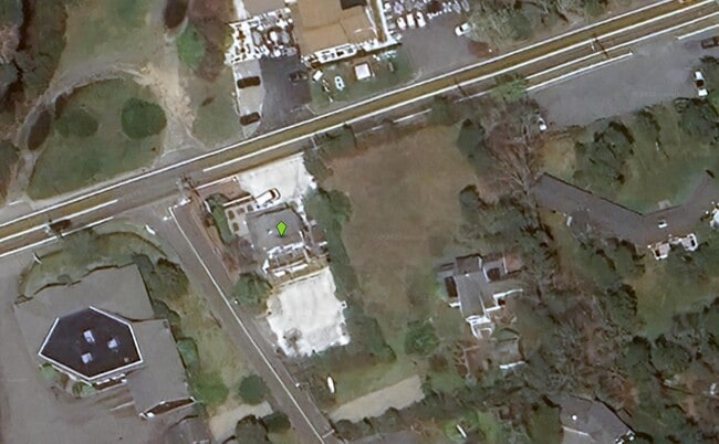
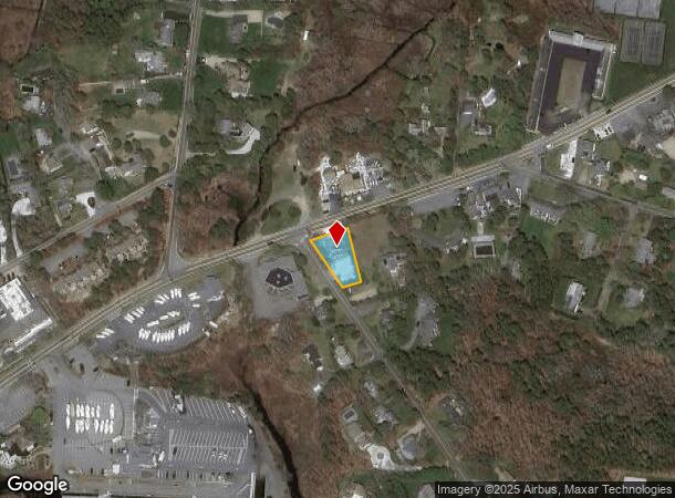
Property Record
749 Route 28, Harwich Port, MA 02646
NEARBY LISTINGS FOR SALE OR LEASE
Property Detail
749 Route 28
HARW-000016-000000-A000002
& Rte 28
Restaurantbuilding
Barnstable
AE
Massachusetts
25001C0616J
0.26 AC
2025
Cape Cod
2025
Other Market Areas
011200
Barnstable Town, MA
1,856 SF
DEMOGRAPHICS near 749 Route 28
1 Mile
3 Mile
5 Mile
2024 Total Population
2,376
11,388
29,509
2029 Population
2,581
12,142
31,199
Pop Growth 2024-2029
+ 8.63%
+ 6.62%
+ 5.73%
Average Age
55
53
52
2024 Total Households
1,234
5,583
14,149
HH Growth 2024-2029
+ 8.18%
+ 6.68%
+ 5.80%
Median Household Inc
$71,725
$74,840
$80,016
Avg Household Size
1.90
2.00
2.00
2024 Avg HH Vehicles
2.00
2.00
2.00
Median Home Value
$698,694
$677,362
$625,897
Median Year Built
1968
1973
1974
Nearby Places
Map Layers
Map Styles
 Street
 Aerial
- Restaurants
- Banks
- Shops
- Fitness
- Groceries
PUBLIC TRANSPORTATION
AIRPORT
Nantucket Memorial
DRIVE
WALK
Distance
Nantucket Memorial
175 min
45.9 mi
Freight Ports
Port of New Bedford Harbor
DRIVE
WALK
Distance
Port of New Bedford Harbor
89 min
61.1 mi
Nearby Properties
Address
Land Use
TOTAL SIZE
Lot Size
Zoning
Address
Land Use
TOTAL SIZE
Lot Size
Zoning
49.58 AC
E
Address
Land Use
TOTAL SIZE
Lot Size
Zoning
13.34 AC
E
Address
Land Use
TOTAL SIZE
Lot Size
Zoning
2,117 SF
Address
Land Use
TOTAL SIZE
Lot Size
Zoning
7.03 AC
Address
Land Use
TOTAL SIZE
Lot Size
Zoning
184.82 AC
E
Address
Land Use
TOTAL SIZE
Lot Size
Zoning
12.93 AC
R
Address
Land Use
TOTAL SIZE
Lot Size
Zoning
3,200 SF
142.32 AC
E
Address
Land Use
TOTAL SIZE
Lot Size
Zoning
3.58 AC
R
Address
Land Use
TOTAL SIZE
Lot Size
Zoning
3,480 SF
22.78 AC
E
Address
Land Use
TOTAL SIZE
Lot Size
Zoning
10.19 AC
R30
Address
Land Use
TOTAL SIZE
Lot Size
Zoning
3.02 AC
R
Address
Land Use
TOTAL SIZE
Lot Size
Zoning
153.96 AC
E
Address
Land Use
TOTAL SIZE
Lot Size
Zoning
4.88 AC
E
Address
Land Use
TOTAL SIZE
Lot Size
Zoning
59,054 SF
9.53 AC
R
Address
Land Use
TOTAL SIZE
Lot Size
Zoning
1.52 AC
R
Address
Land Use
TOTAL SIZE
Lot Size
Zoning
Address
Land Use
TOTAL SIZE
Lot Size
Zoning
2,003 SF
1.57 AC
R
Address
Land Use
TOTAL SIZE
Lot Size
Zoning
0.78 AC
R
Address
Land Use
TOTAL SIZE
Lot Size
Zoning
72 AC
MC
Address
Land Use
TOTAL SIZE
Lot Size
Zoning
1.32 AC
R
Address
Land Use
TOTAL SIZE
Lot Size
Zoning
6,276 SF
0.80 AC
R
Address
Land Use
TOTAL SIZE
Lot Size
Zoning
0.80 AC
R
Address
Land Use
TOTAL SIZE
Lot Size
Zoning
9.77 AC
Address
Land Use
TOTAL SIZE
Lot Size
Zoning
1.17 AC
R
Address
Land Use
TOTAL SIZE
Lot Size
Zoning
0.41 AC
R
Address
Land Use
TOTAL SIZE
Lot Size
Zoning
3,080 SF
2.61 AC
R
Address
Land Use
TOTAL SIZE
Lot Size
Zoning
1.55 AC
R
Address
Land Use
TOTAL SIZE
Lot Size
Zoning
26,948 SF
Address
Land Use
TOTAL SIZE
Lot Size
Zoning
1.03 AC
R
Address
Land Use
TOTAL SIZE
Lot Size
Zoning
4,744 SF
0.44 AC
R
The World's #1 Commercial Real Estate Marketplace
Connect with us
© 2025 CoStar Group
The information above has been obtained from sources believed reliable. While we do not doubt its accuracy we have not verified it and make no guarantee, warranty or representation about it. It is your responsibility to independently confirm its accuracy and completeness. Any projections, opinions, assumptions, or estimates used are for example only and do not represent the current or future performance of the property. The value of this transaction to you depends on tax and other factors which should be evaluated by your tax, financial, and legal advisors. You and your advisors should conduct a careful, independent investigation of the property to determine to your satisfaction the suitability of the property for your needs.