Property Record
749 Simpson St, Grimesland, NC 27837

Save to a Folder
{{folder.Name}}
{{folder.ListingIds.length}} Properties
{{folder.ListingIds.length}} Property
Create a New Folder
Property Detail
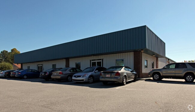
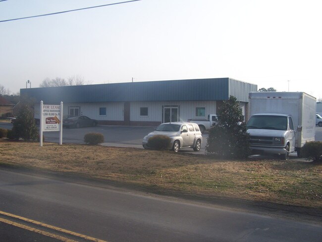
749 Simpson St
022893
OFFICE/WHSE,SIMPSON ST.
Distributionwarehouseregional
PITT
GB
North Carolina
B and X Area of moderate flood hazard, usually the area between the limits of the 100-year and 500-year floods.
0.88 AC
2025
North Carolina Northeast Area
2025
Other Market Areas
001301
Greenville, NC
12,000 SF
NEARBY LISTINGS FOR SALE OR LEASE
-
-
View all Grimesland listings for sale on LoopNet.com
DEMOGRAPHICS near 749 Simpson St
1 mile
3 mile
5 mile
2025 Total Population
2,404
14,524
46,863
2030 Population
2,447
14,873
48,424
Pop Growth 2025-2030
+ 1.79%
+ 2.40%
+ 3.33%
Average Age
40
39
38
2025 Total Households
892
5,379
20,074
HH Growth 2025-2030
+ 1.91%
+ 2.53%
+ 3.54%
Median Household Inc
$95,634
$91,804
$67,474
Avg Household Size
2.70
2.70
2.30
2025 Avg HH Vehicles
2.00
2.00
2.00
Median Home Value
$256,288
$272,486
$257,505
Median Year Built
1992
1993
1992
Nearby Places
Map Layers
Map Styles
 Street
 Aerial
Layers
 Traffic
 Biking
Places
Listings with unknown addresses are not visible on the map
- Restaurants
- Banks
- Shops
- Fitness
- Groceries
PUBLIC TRANSPORTATION
AIRPORT
Pitt-Greenville
Drive
Walk
Distance
Pitt-Greenville
21 min
12.4 mi
Freight Ports
Port of Morehead City
Drive
Walk
Distance
Port of Morehead City
122 min
81.8 mi
Nearby Properties
Address
Land Use
TOTAL SIZE
Lot Size
Zoning
Address
Land Use
TOTAL SIZE
Lot Size
Zoning
20,138 SF
26.90 AC
R6A
Address
Land Use
TOTAL SIZE
Lot Size
Zoning
145,476 SF
18.92 AC
CG
Address
Land Use
TOTAL SIZE
Lot Size
Zoning
138,364 SF
18.19 AC
CH
Address
Land Use
TOTAL SIZE
Lot Size
Zoning
31,116 SF
19.98 AC
OR
Address
Land Use
TOTAL SIZE
Lot Size
Zoning
50,328 SF
6.58 AC
CG
Address
Land Use
TOTAL SIZE
Lot Size
Zoning
40,720 SF
8.32 AC
CG
Address
Land Use
TOTAL SIZE
Lot Size
Zoning
18,994 SF
4.99 AC
OR
Address
Land Use
TOTAL SIZE
Lot Size
Zoning
86,500 SF
13.31 AC
GB
Address
Land Use
TOTAL SIZE
Lot Size
Zoning
20,420 SF
12.16 AC
CG
Address
Land Use
TOTAL SIZE
Lot Size
Zoning
21,486 SF
3.62 AC
RR
Address
Land Use
TOTAL SIZE
Lot Size
Zoning
119.73 AC
RA20
Address
Land Use
TOTAL SIZE
Lot Size
Zoning
19,354 SF
2.53 AC
CG
Address
Land Use
TOTAL SIZE
Lot Size
Zoning
19,295 SF
5.12 AC
RR
Address
Land Use
TOTAL SIZE
Lot Size
Zoning
17,754 SF
19.81 AC
RR
Address
Land Use
TOTAL SIZE
Lot Size
Zoning
4,590 SF
1.34 AC
CG
Address
Land Use
TOTAL SIZE
Lot Size
Zoning
14,136 SF
1.46 AC
CH
Address
Land Use
TOTAL SIZE
Lot Size
Zoning
46,300 SF
5.61 AC
GB
Address
Land Use
TOTAL SIZE
Lot Size
Zoning
30.71 AC
AR
Address
Land Use
TOTAL SIZE
Lot Size
Zoning
4,845 SF
1.19 AC
CH
Address
Land Use
TOTAL SIZE
Lot Size
Zoning
74.01 AC
RA20
Address
Land Use
TOTAL SIZE
Lot Size
Zoning
4,524 SF
3.34 AC
R6
Address
Land Use
TOTAL SIZE
Lot Size
Zoning
8,194 SF
5.11 AC
R40
Address
Land Use
TOTAL SIZE
Lot Size
Zoning
30.57 AC
RA20
Address
Land Use
TOTAL SIZE
Lot Size
Zoning
2,893 SF
1.01 AC
CG
Address
Land Use
TOTAL SIZE
Lot Size
Zoning
5,320 SF
2.52 AC
OR
Address
Land Use
TOTAL SIZE
Lot Size
Zoning
14,960 SF
1.62 AC
GB
Address
Land Use
TOTAL SIZE
Lot Size
Zoning
8,250 SF
1.89 AC
GB
Address
Land Use
TOTAL SIZE
Lot Size
Zoning
9,801 SF
0.89 AC
CH
Address
Land Use
TOTAL SIZE
Lot Size
Zoning
3,874 SF
1.22 AC
CG
Address
Land Use
TOTAL SIZE
Lot Size
Zoning
90.93 AC
RR
The World's #1 Commercial Real Estate Marketplace
Connect with us
© 2026 CoStar Group
The information above has been obtained from sources believed reliable. While we do not doubt its accuracy we have not verified it and make no guarantee, warranty or representation about it. It is your responsibility to independently confirm its accuracy and completeness. Any projections, opinions, assumptions, or estimates used are for example only and do not represent the current or future performance of the property. The value of this transaction to you depends on tax and other factors which should be evaluated by your tax, financial, and legal advisors. You and your advisors should conduct a careful, independent investigation of the property to determine to your satisfaction the suitability of the property for your needs.