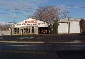
Property Record
749 Snipes St, The Dalles, OR 97058

NEARBY LISTINGS FOR SALE OR LEASE
Property Detail
749 Snipes St
Other Market Areas
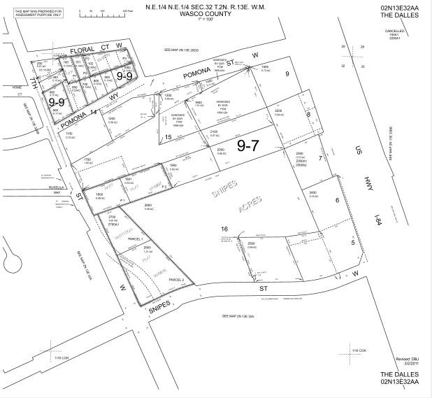
Snipes Acres
The Dalles, OR
SECTION 32 TOWNSHIP 2N RANGE 13E QUARTER AA PRCL 2600 MAPTAX LOT: 02N13 E32AA02600 00
2N 13E 32 AA 2600
Wasco
Commercialnec
Oregon
2022
5.46 AC
2025
Oregon East Area
970500
DEMOGRAPHICS near 749 Snipes St
1 Mile
3 Mile
5 Mile
2024 Total Population
4,901
16,847
21,025
2029 Population
4,844
16,777
20,920
Pop Growth 2024-2029
(1.16%)
(0.42%)
(0.50%)
Average Age
40
41
42
2024 Total Households
1,889
6,533
8,171
HH Growth 2024-2029
(1.27%)
(0.52%)
(0.60%)
Median Household Inc
$51,412
$56,542
$58,921
Avg Household Size
2.50
2.50
2.50
2024 Avg HH Vehicles
2.00
2.00
2.00
Median Home Value
$212,148
$290,889
$313,424
Median Year Built
1978
1968
1970
Nearby Places
Map Layers
Map Styles
 Street
 Aerial
- Restaurants
- Banks
- Shops
- Fitness
- Groceries
SALE & LEASE HISTORY
LISTING DATE
SALE/LEASE

Sep 24, 2016
For Sale
Mar 06, 2018
For Sale
Nearby Properties
Address
Land Use
TOTAL SIZE
Lot Size
Zoning
Address
Land Use
TOTAL SIZE
Lot Size
Zoning
Address
Land Use
TOTAL SIZE
Lot Size
Zoning
Address
Land Use
TOTAL SIZE
Lot Size
Zoning
26.33 AC
Address
Land Use
TOTAL SIZE
Lot Size
Zoning
Address
Land Use
TOTAL SIZE
Lot Size
Zoning
Address
Land Use
TOTAL SIZE
Lot Size
Zoning
Address
Land Use
TOTAL SIZE
Lot Size
Zoning
Address
Land Use
TOTAL SIZE
Lot Size
Zoning
Address
Land Use
TOTAL SIZE
Lot Size
Zoning
Address
Land Use
TOTAL SIZE
Lot Size
Zoning
30.74 AC
I INDUSTRI
Address
Land Use
TOTAL SIZE
Lot Size
Zoning
5.52 AC
CG GENERAL
Address
Land Use
TOTAL SIZE
Lot Size
Zoning
Address
Land Use
TOTAL SIZE
Lot Size
Zoning
Address
Land Use
TOTAL SIZE
Lot Size
Zoning
9.38 AC
CG GENERAL
Address
Land Use
TOTAL SIZE
Lot Size
Zoning
3.69 AC
RH HIGH/ME
Address
Land Use
TOTAL SIZE
Lot Size
Zoning
Address
Land Use
TOTAL SIZE
Lot Size
Zoning
Address
Land Use
TOTAL SIZE
Lot Size
Zoning
2.10 AC
CG
Address
Land Use
TOTAL SIZE
Lot Size
Zoning
3.49 AC
CG GENERAL
Address
Land Use
TOTAL SIZE
Lot Size
Zoning
4.13 AC
CG GENERAL
Address
Land Use
TOTAL SIZE
Lot Size
Zoning
Address
Land Use
TOTAL SIZE
Lot Size
Zoning
1.20 AC
Address
Land Use
TOTAL SIZE
Lot Size
Zoning
Address
Land Use
TOTAL SIZE
Lot Size
Zoning
4.28 AC
CG GENERAL
Address
Land Use
TOTAL SIZE
Lot Size
Zoning
7.78 AC
CG
Address
Land Use
TOTAL SIZE
Lot Size
Zoning
4.23 AC
Address
Land Use
TOTAL SIZE
Lot Size
Zoning
82.43 AC
I
Address
Land Use
TOTAL SIZE
Lot Size
Zoning
6.69 AC
I
Address
Land Use
TOTAL SIZE
Lot Size
Zoning
Address
Land Use
TOTAL SIZE
Lot Size
Zoning
2.02 AC
CG
The World's #1 Commercial Real Estate Marketplace
Connect with us
© 2025 CoStar Group
The information above has been obtained from sources believed reliable. While we do not doubt its accuracy we have not verified it and make no guarantee, warranty or representation about it. It is your responsibility to independently confirm its accuracy and completeness. Any projections, opinions, assumptions, or estimates used are for example only and do not represent the current or future performance of the property. The value of this transaction to you depends on tax and other factors which should be evaluated by your tax, financial, and legal advisors. You and your advisors should conduct a careful, independent investigation of the property to determine to your satisfaction the suitability of the property for your needs.