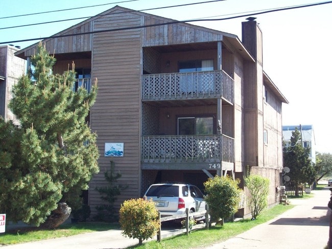
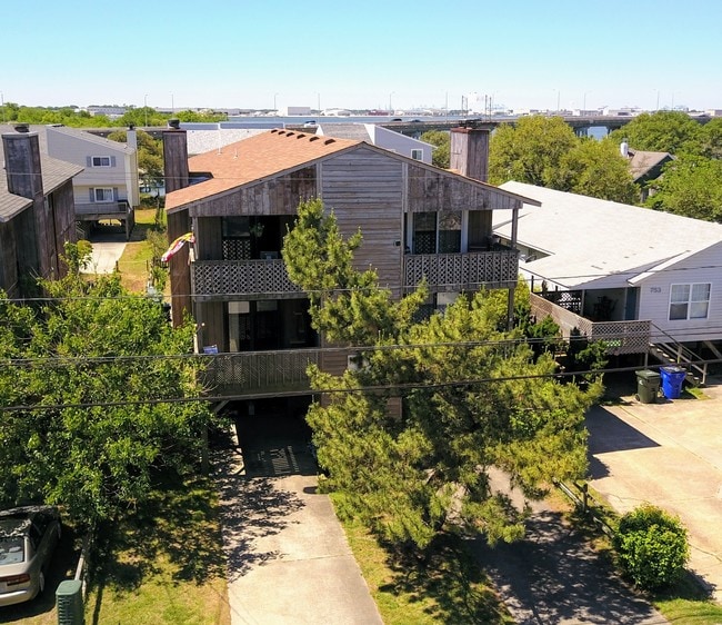
Property Record
749 W Ocean View Ave, Norfolk, VA 23503
NEARBY LISTINGS FOR SALE OR LEASE
Property Detail
749 W Ocean View Ave
Virginia Beach-Norfolk-Newport News, VA-NC
Fishermans Cove
43765434
Norfolk City
Condominium
Virginia
AE
0.05 AC
5101040009H
Willough Bay
1,074 SF
Hampton Roads
DEMOGRAPHICS near 749 W Ocean View Ave
1 Mile
3 Mile
5 Mile
2024 Total Population
14,491
41,725
107,665
2029 Population
14,182
40,742
105,168
Pop Growth 2024-2029
(2.13%)
(2.36%)
(2.32%)
Average Age
30
34
36
2024 Total Households
2,475
13,112
40,735
HH Growth 2024-2029
(2.42%)
(2.72%)
(2.63%)
Median Household Inc
$55,714
$59,244
$60,176
Avg Household Size
2.00
2.20
2.30
2024 Avg HH Vehicles
2.00
2.00
2.00
Median Home Value
$309,936
$248,281
$253,375
Median Year Built
1971
1963
1963
Nearby Places
- Restaurants
- Banks
- Shops
- Fitness
- Groceries
PUBLIC TRANSPORTATION
COMMUTER RAIL
Norfolk (Northeast Regional - Amtrak)
DRIVE
WALK
Distance
Norfolk (Northeast Regional - Amtrak)
17 min
9.7 mi
AIRPORT
Norfolk International
DRIVE
WALK
Distance
Norfolk International
15 min
7.6 mi
Newport News/Williamsburg International
DRIVE
WALK
Distance
Newport News/Williamsburg International
31 min
20.4 mi
Freight Ports
Virginia Port Authority - Norfolk
DRIVE
WALK
Distance
Virginia Port Authority - Norfolk
17 min
7.5 mi
SALE & LEASE HISTORY
LISTING DATE
SALE/LEASE

May 17, 2017
For Sale
Nearby Properties
Address
Land Use
TOTAL SIZE
Lot Size
Zoning
Address
Land Use
TOTAL SIZE
Lot Size
Zoning
777.89 AC
Address
Land Use
TOTAL SIZE
Lot Size
Zoning
8,423 SF
53.95 AC
Address
Land Use
TOTAL SIZE
Lot Size
Zoning
103,496 SF
25.81 AC
IN1
Address
Land Use
TOTAL SIZE
Lot Size
Zoning
14.02 AC
Address
Land Use
TOTAL SIZE
Lot Size
Zoning
41,754 SF
6.01 AC
Address
Land Use
TOTAL SIZE
Lot Size
Zoning
68.02 AC
Address
Land Use
TOTAL SIZE
Lot Size
Zoning
25,880 SF
31.21 AC
91
Address
Land Use
TOTAL SIZE
Lot Size
Zoning
23.85 AC
IN1
Address
Land Use
TOTAL SIZE
Lot Size
Zoning
15,898 SF
9.91 AC
IN1
Address
Land Use
TOTAL SIZE
Lot Size
Zoning
28,064 SF
7.48 AC
C2
Address
Land Use
TOTAL SIZE
Lot Size
Zoning
63,459 SF
20.06 AC
IN1
Address
Land Use
TOTAL SIZE
Lot Size
Zoning
28,708 SF
3.16 AC
C2
Address
Land Use
TOTAL SIZE
Lot Size
Zoning
251.28 AC
OSP
Address
Land Use
TOTAL SIZE
Lot Size
Zoning
7,240 SF
2.80 AC
R12
Address
Land Use
TOTAL SIZE
Lot Size
Zoning
10,580 SF
5.63 AC
R12
Address
Land Use
TOTAL SIZE
Lot Size
Zoning
2,214 SF
7.78 AC
Address
Land Use
TOTAL SIZE
Lot Size
Zoning
85,600 SF
3.92 AC
Address
Land Use
TOTAL SIZE
Lot Size
Zoning
7.08 AC
Address
Land Use
TOTAL SIZE
Lot Size
Zoning
21,052 SF
4.45 AC
R12
Address
Land Use
TOTAL SIZE
Lot Size
Zoning
5.77 AC
Address
Land Use
TOTAL SIZE
Lot Size
Zoning
26,080 SF
6.93 AC
C2
Address
Land Use
TOTAL SIZE
Lot Size
Zoning
42,592 SF
3.06 AC
R13
Address
Land Use
TOTAL SIZE
Lot Size
Zoning
53,229 SF
6.81 AC
IN1
Address
Land Use
TOTAL SIZE
Lot Size
Zoning
32.93 AC
Address
Land Use
TOTAL SIZE
Lot Size
Zoning
41,316 SF
2.45 AC
R12
Address
Land Use
TOTAL SIZE
Lot Size
Zoning
6,150 SF
8.07 AC
PDRSPECTR
Address
Land Use
TOTAL SIZE
Lot Size
Zoning
8.36 AC
C2
Address
Land Use
TOTAL SIZE
Lot Size
Zoning
58,990 SF
3.60 AC
C2
Address
Land Use
TOTAL SIZE
Lot Size
Zoning
43,040 SF
2.02 AC
IN1
Address
Land Use
TOTAL SIZE
Lot Size
Zoning
21,264 SF
2.41 AC
The World's #1 Commercial Real Estate Marketplace
Connect with us
© 2025 CoStar Group
The information above has been obtained from sources believed reliable. While we do not doubt its accuracy we have not verified it and make no guarantee, warranty or representation about it. It is your responsibility to independently confirm its accuracy and completeness. Any projections, opinions, assumptions, or estimates used are for example only and do not represent the current or future performance of the property. The value of this transaction to you depends on tax and other factors which should be evaluated by your tax, financial, and legal advisors. You and your advisors should conduct a careful, independent investigation of the property to determine to your satisfaction the suitability of the property for your needs.