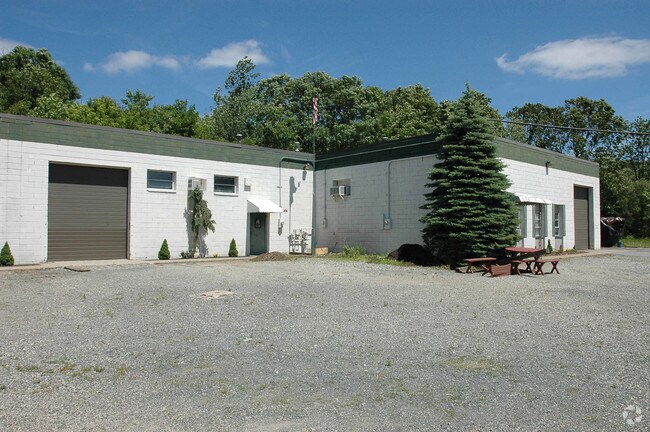
Property Record
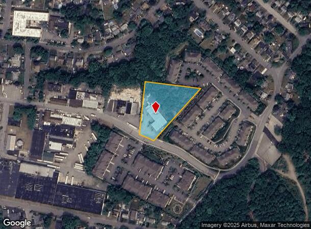
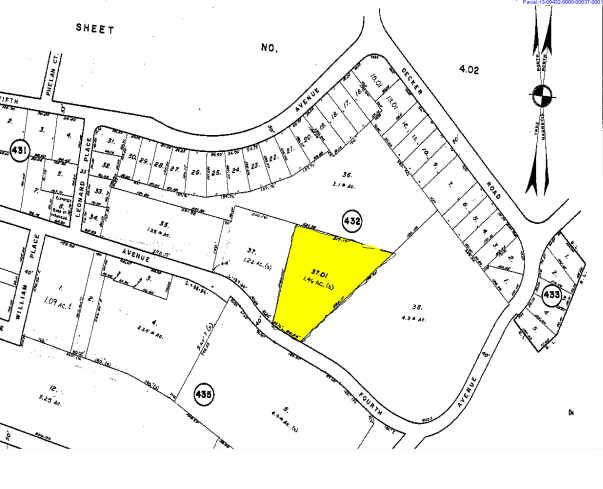
75 4Th Ave, Haskell, NJ 07420
NEARBY LISTINGS FOR SALE OR LEASE
Property Detail
75 4Th Ave
13-00432-0000-00037-01
Passaic
Industrialgeneral
New Jersey
X
37.1
34031C0143G
1.50 AC
2024
Suburban Passaic
2025
Northern New Jersey
154006
New York-Jersey City-White Plains, NY-NJ
DEMOGRAPHICS near 75 4Th Ave
1 Mile
3 Mile
5 Mile
2024 Total Population
5,827
41,642
103,052
2029 Population
5,762
41,283
102,525
Pop Growth 2024-2029
(1.12%)
(0.86%)
(0.51%)
Average Age
45
43
43
2024 Total Households
2,213
15,975
38,075
HH Growth 2024-2029
(1.22%)
(1.00%)
(0.69%)
Median Household Inc
$100,829
$107,565
$119,740
Avg Household Size
2.50
2.50
2.60
2024 Avg HH Vehicles
2.00
2.00
2.00
Median Home Value
$323,105
$379,794
$437,400
Median Year Built
1963
1964
1966
Nearby Places
Map Layers
Map Styles
 Street
 Aerial
- Restaurants
- Banks
- Shops
- Fitness
- Groceries
PUBLIC TRANSPORTATION
COMMUTER RAIL
Lincoln Park (Montclair-Boonton Line - NJ Transit Commuter Rail (NJ Transit))
DRIVE
WALK
Distance
Lincoln Park (Montclair-Boonton Line - NJ Transit Commuter Rail (NJ Transit))
14 min
8.4 mi
Mountain View (Montclair-Boonton Line - NJ Transit Commuter Rail (NJ Transit))
DRIVE
WALK
Distance
Mountain View (Montclair-Boonton Line - NJ Transit Commuter Rail (NJ Transit))
15 min
10.0 mi
AIRPORT
Newark Liberty International
DRIVE
WALK
Distance
Newark Liberty International
40 min
32.2 mi
LaGuardia
DRIVE
WALK
Distance
LaGuardia
53 min
35.8 mi
Westchester County
DRIVE
WALK
Distance
Westchester County
60 min
44.8 mi
Freight Ports
Maher Terminal
DRIVE
WALK
Distance
Maher Terminal
48 min
32.4 mi
Nearby Properties
Address
Land Use
TOTAL SIZE
Lot Size
Zoning
Address
Land Use
TOTAL SIZE
Lot Size
Zoning
Address
Land Use
TOTAL SIZE
Lot Size
Zoning
10.88 AC
Address
Land Use
TOTAL SIZE
Lot Size
Zoning
264,080 SF
44.44 AC
HB
Address
Land Use
TOTAL SIZE
Lot Size
Zoning
23.48 AC
Address
Land Use
TOTAL SIZE
Lot Size
Zoning
8.07 AC
IP
Address
Land Use
TOTAL SIZE
Lot Size
Zoning
14.04 AC
B2
Address
Land Use
TOTAL SIZE
Lot Size
Zoning
10.42 AC
B2
Address
Land Use
TOTAL SIZE
Lot Size
Zoning
231.26 AC
PRC
Address
Land Use
TOTAL SIZE
Lot Size
Zoning
7.58 AC
R-4
Address
Land Use
TOTAL SIZE
Lot Size
Zoning
1,675.67 AC
Address
Land Use
TOTAL SIZE
Lot Size
Zoning
6.99 AC
IP
Address
Land Use
TOTAL SIZE
Lot Size
Zoning
Address
Land Use
TOTAL SIZE
Lot Size
Zoning
6 AC
IP
Address
Land Use
TOTAL SIZE
Lot Size
Zoning
4.96 AC
I3
Address
Land Use
TOTAL SIZE
Lot Size
Zoning
2.93 AC
B-5
Address
Land Use
TOTAL SIZE
Lot Size
Zoning
2.50 AC
B2
Address
Land Use
TOTAL SIZE
Lot Size
Zoning
357,779 SF
16.98 AC
Address
Land Use
TOTAL SIZE
Lot Size
Zoning
434 SF
53.04 AC
I-3
Address
Land Use
TOTAL SIZE
Lot Size
Zoning
103,650 SF
4.81 AC
I-1
Address
Land Use
TOTAL SIZE
Lot Size
Zoning
4.48 AC
R-6
Address
Land Use
TOTAL SIZE
Lot Size
Zoning
14.40 AC
Address
Land Use
TOTAL SIZE
Lot Size
Zoning
3.43 AC
B2
Address
Land Use
TOTAL SIZE
Lot Size
Zoning
3.59 AC
IP
Address
Land Use
TOTAL SIZE
Lot Size
Zoning
88,929 SF
5.93 AC
I-1
Address
Land Use
TOTAL SIZE
Lot Size
Zoning
Address
Land Use
TOTAL SIZE
Lot Size
Zoning
2.93 AC
IP
Address
Land Use
TOTAL SIZE
Lot Size
Zoning
44.65 AC
I-3
Address
Land Use
TOTAL SIZE
Lot Size
Zoning
8.33 AC
R-4
Address
Land Use
TOTAL SIZE
Lot Size
Zoning
26.10 AC
R15
Address
Land Use
TOTAL SIZE
Lot Size
Zoning
3.02 AC
IP
The World's #1 Commercial Real Estate Marketplace
Connect with us
© 2025 CoStar Group
The information above has been obtained from sources believed reliable. While we do not doubt its accuracy we have not verified it and make no guarantee, warranty or representation about it. It is your responsibility to independently confirm its accuracy and completeness. Any projections, opinions, assumptions, or estimates used are for example only and do not represent the current or future performance of the property. The value of this transaction to you depends on tax and other factors which should be evaluated by your tax, financial, and legal advisors. You and your advisors should conduct a careful, independent investigation of the property to determine to your satisfaction the suitability of the property for your needs.