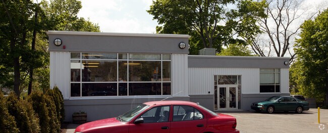
Property Record
7R Bridge St, Danvers, MA 01923

NEARBY LISTINGS FOR SALE OR LEASE
Property Detail
7R Bridge St
DANV-000060-000000-000052
Essex
Sfr
Massachusetts
X
51
25009C0416H
0.23 AC
0
Danvers/Beverly
2025
Boston
211100
Boston-Cambridge-Newton, MA-NH
894 SF
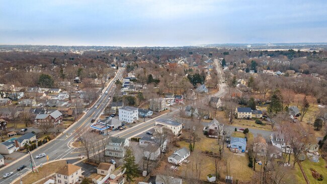
DEMOGRAPHICS near 7R Bridge St
1 Mile
3 Mile
5 Mile
2024 Total Population
10,045
103,539
189,489
2029 Population
10,027
102,570
188,372
Pop Growth 2024-2029
(0.18%)
(0.94%)
(0.59%)
Average Age
43
42
42
2024 Total Households
4,024
44,159
77,197
HH Growth 2024-2029
(0.30%)
(1.11%)
(0.73%)
Median Household Inc
$107,094
$82,275
$90,044
Avg Household Size
2.40
2.30
2.30
2024 Avg HH Vehicles
2.00
2.00
2.00
Median Home Value
$553,159
$502,407
$551,623
Median Year Built
1958
1953
1958
Nearby Places
Map Layers
Map Styles
 Street
 Aerial
- Restaurants
- Banks
- Shops
- Fitness
- Groceries
PUBLIC TRANSPORTATION
COMMUTER RAIL
Beverly Depot (Newburyport/Rockport Line - Massachusetts Bay Transportation Authority Commuter Rail (Purple Line))
DRIVE
WALK
Distance
Beverly Depot (Newburyport/Rockport Line - Massachusetts Bay Transportation Authority Commuter Rail (Purple Line))
5 min
2.3 mi
Montserrat (Newburyport/Rockport Line - Massachusetts Bay Transportation Authority Commuter Rail (Purple Line))
DRIVE
WALK
Distance
Montserrat (Newburyport/Rockport Line - Massachusetts Bay Transportation Authority Commuter Rail (Purple Line))
5 min
2.5 mi
AIRPORT
General Edward Lawrence Logan International
DRIVE
WALK
Distance
General Edward Lawrence Logan International
32 min
17.8 mi
Freight Ports
Port of Boston
DRIVE
WALK
Distance
Port of Boston
38 min
23.6 mi
SALE & LEASE HISTORY
LISTING DATE
SALE/LEASE

Mar 19, 2024
For Lease
Nearby Properties
Address
Land Use
TOTAL SIZE
Lot Size
Zoning
Address
Land Use
TOTAL SIZE
Lot Size
Zoning
48.89 AC
IG
Address
Land Use
TOTAL SIZE
Lot Size
Zoning
10,368 SF
33.83 AC
R3
Address
Land Use
TOTAL SIZE
Lot Size
Zoning
252,965 SF
56.44 AC
R3
Address
Land Use
TOTAL SIZE
Lot Size
Zoning
14.69 AC
I
Address
Land Use
TOTAL SIZE
Lot Size
Zoning
192,341 SF
2.10 AC
B5
Address
Land Use
TOTAL SIZE
Lot Size
Zoning
49 AC
I2
Address
Land Use
TOTAL SIZE
Lot Size
Zoning
267,051 SF
41.08 AC
R10
Address
Land Use
TOTAL SIZE
Lot Size
Zoning
17.60 AC
R1A
Address
Land Use
TOTAL SIZE
Lot Size
Zoning
9.71 AC
BR
Address
Land Use
TOTAL SIZE
Lot Size
Zoning
228,295 SF
12.50 AC
RMD
Address
Land Use
TOTAL SIZE
Lot Size
Zoning
231,509 SF
17.71 AC
R10
Address
Land Use
TOTAL SIZE
Lot Size
Zoning
172.50 AC
R3
Address
Land Use
TOTAL SIZE
Lot Size
Zoning
182,122 SF
23.33 AC
R10
Address
Land Use
TOTAL SIZE
Lot Size
Zoning
206.65 AC
R1B
Address
Land Use
TOTAL SIZE
Lot Size
Zoning
207,237 SF
16.73 AC
RMD
Address
Land Use
TOTAL SIZE
Lot Size
Zoning
11.08 AC
R4
Address
Land Use
TOTAL SIZE
Lot Size
Zoning
223,689 SF
11.60 AC
R1
Address
Land Use
TOTAL SIZE
Lot Size
Zoning
195,527 SF
16.60 AC
CG
Address
Land Use
TOTAL SIZE
Lot Size
Zoning
170,652 SF
23.73 AC
HD
Address
Land Use
TOTAL SIZE
Lot Size
Zoning
408,207 SF
37.12 AC
C3
Address
Land Use
TOTAL SIZE
Lot Size
Zoning
4.14 AC
NRCC
Address
Land Use
TOTAL SIZE
Lot Size
Zoning
358,662 SF
36.98 AC
IR
Address
Land Use
TOTAL SIZE
Lot Size
Zoning
162,182 SF
9.53 AC
IR
Address
Land Use
TOTAL SIZE
Lot Size
Zoning
111.24 AC
R3
Address
Land Use
TOTAL SIZE
Lot Size
Zoning
118,110 SF
0.67 AC
CC
Address
Land Use
TOTAL SIZE
Lot Size
Zoning
37,553 SF
238.29 AC
IR
Address
Land Use
TOTAL SIZE
Lot Size
Zoning
177,782 SF
12.21 AC
I2
Address
Land Use
TOTAL SIZE
Lot Size
Zoning
14.50 AC
R1
Address
Land Use
TOTAL SIZE
Lot Size
Zoning
278,284 SF
23.20 AC
RSD
Address
Land Use
TOTAL SIZE
Lot Size
Zoning
123,588 SF
1.50 AC
B5
The World's #1 Commercial Real Estate Marketplace
Connect with us
© 2026 CoStar Group
The information above has been obtained from sources believed reliable. While we do not doubt its accuracy we have not verified it and make no guarantee, warranty or representation about it. It is your responsibility to independently confirm its accuracy and completeness. Any projections, opinions, assumptions, or estimates used are for example only and do not represent the current or future performance of the property. The value of this transaction to you depends on tax and other factors which should be evaluated by your tax, financial, and legal advisors. You and your advisors should conduct a careful, independent investigation of the property to determine to your satisfaction the suitability of the property for your needs.