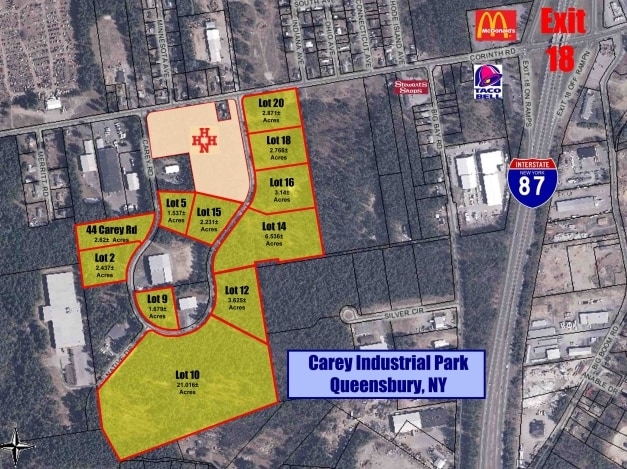
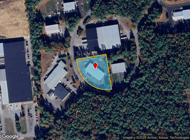
Property Record
75 Carey Rd, Queensbury, NY 12804
NEARBY LISTINGS FOR SALE OR LEASE
Property Detail
75 Carey Rd
Glens Falls, NY
VAC 481.97'RF LOT 9
523400-308-020-0001-003-003-0000
Warren
Industrialgeneral
New York
2025
3.003
2024
1.68 AC
070802
Warren County
12,000 SF
Albany/Schenectady/Troy
DEMOGRAPHICS near 75 Carey Rd
1 Mile
3 Mile
5 Mile
2024 Total Population
2,426
33,182
53,497
2029 Population
2,394
33,080
53,426
Pop Growth 2024-2029
(1.32%)
(0.31%)
(0.13%)
Average Age
42
42
43
2024 Total Households
929
14,293
23,101
HH Growth 2024-2029
(1.40%)
(0.41%)
(0.23%)
Median Household Inc
$81,944
$77,016
$77,404
Avg Household Size
2.50
2.30
2.30
2024 Avg HH Vehicles
2.00
2.00
2.00
Median Home Value
$244,214
$213,963
$224,128
Median Year Built
1986
1974
1976
Nearby Places
Map Layers
Map Styles
 Street
 Aerial
- Restaurants
- Banks
- Shops
- Fitness
- Groceries
Nearby Properties
Address
Land Use
TOTAL SIZE
Lot Size
Zoning
Address
Land Use
TOTAL SIZE
Lot Size
Zoning
273,242 SF
11.07 AC
GC2
Address
Land Use
TOTAL SIZE
Lot Size
Zoning
115.90 AC
WR
Address
Land Use
TOTAL SIZE
Lot Size
Zoning
161,338 SF
1.74 AC
GC2
Address
Land Use
TOTAL SIZE
Lot Size
Zoning
154,236 SF
104.60 AC
RR-3A
Address
Land Use
TOTAL SIZE
Lot Size
Zoning
Address
Land Use
TOTAL SIZE
Lot Size
Zoning
191,130 SF
20.09 AC
R-1A
Address
Land Use
TOTAL SIZE
Lot Size
Zoning
938 SF
80.03 AC
C1
Address
Land Use
TOTAL SIZE
Lot Size
Zoning
Address
Land Use
TOTAL SIZE
Lot Size
Zoning
1.91 AC
HI
Address
Land Use
TOTAL SIZE
Lot Size
Zoning
792 SF
48.99 AC
MDR
Address
Land Use
TOTAL SIZE
Lot Size
Zoning
183,950 SF
11.41 AC
C1
Address
Land Use
TOTAL SIZE
Lot Size
Zoning
144,029 SF
28.34 AC
R1
Address
Land Use
TOTAL SIZE
Lot Size
Zoning
31,456 SF
15.49 AC
MDR
Address
Land Use
TOTAL SIZE
Lot Size
Zoning
91,000 SF
0.52 AC
GC2
Address
Land Use
TOTAL SIZE
Lot Size
Zoning
Address
Land Use
TOTAL SIZE
Lot Size
Zoning
130,142 SF
20.71 AC
CI
Address
Land Use
TOTAL SIZE
Lot Size
Zoning
70,176 SF
3.50 AC
GC1
Address
Land Use
TOTAL SIZE
Lot Size
Zoning
1,600 SF
42.56 AC
SPLIT
Address
Land Use
TOTAL SIZE
Lot Size
Zoning
Address
Land Use
TOTAL SIZE
Lot Size
Zoning
16.20 AC
R1
Address
Land Use
TOTAL SIZE
Lot Size
Zoning
8,683 SF
8.27 AC
HI
Address
Land Use
TOTAL SIZE
Lot Size
Zoning
24,476 SF
0.44 AC
CCD
Address
Land Use
TOTAL SIZE
Lot Size
Zoning
176,655 SF
1.91 AC
GC2
Address
Land Use
TOTAL SIZE
Lot Size
Zoning
37,514 SF
4.88 AC
PRD
Address
Land Use
TOTAL SIZE
Lot Size
Zoning
71,996 SF
40.15 AC
RR-3A
Address
Land Use
TOTAL SIZE
Lot Size
Zoning
76,451 SF
23.20 AC
R2
Address
Land Use
TOTAL SIZE
Lot Size
Zoning
128,398 SF
12.23 AC
CI
Address
Land Use
TOTAL SIZE
Lot Size
Zoning
64,654 SF
4.03 AC
GC1
Address
Land Use
TOTAL SIZE
Lot Size
Zoning
87,388 SF
18.79 AC
CI
Address
Land Use
TOTAL SIZE
Lot Size
Zoning
75,238 SF
1.56 AC
CCD
The World's #1 Commercial Real Estate Marketplace
Connect with us
© 2026 CoStar Group
The information above has been obtained from sources believed reliable. While we do not doubt its accuracy we have not verified it and make no guarantee, warranty or representation about it. It is your responsibility to independently confirm its accuracy and completeness. Any projections, opinions, assumptions, or estimates used are for example only and do not represent the current or future performance of the property. The value of this transaction to you depends on tax and other factors which should be evaluated by your tax, financial, and legal advisors. You and your advisors should conduct a careful, independent investigation of the property to determine to your satisfaction the suitability of the property for your needs.