Property Record
75 Chaparral Rd, Georgetown, TX 78628
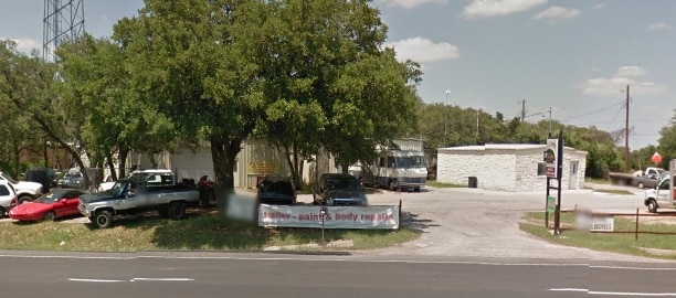
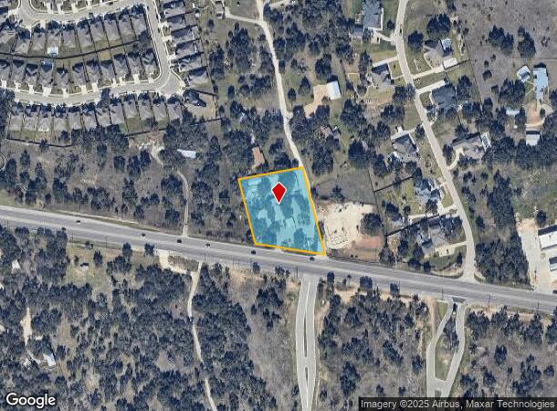
Property Detail
75 Chaparral Rd
Austin-Round Rock-San Marcos, TX
Chaparral Sub
R403578
S7501 - CHAPARRAL SUB, LOT 1, ACRES 1.57
Industrialgeneral
Williamson
X
Texas
48491C0275E
1
2024
1.57 AC
2025
Georgetown
020122
Austin
12,400 SF
NEARBY LISTINGS FOR SALE OR LEASE
DEMOGRAPHICS near 75 Chaparral Rd
1 mile
3 mile
5 mile
2024 Total Population
2,962
15,444
56,598
2029 Population
3,940
20,307
73,075
Pop Growth 2024-2029
+ 33.02%
+ 31.49%
+ 29.11%
Average Age
46
40
39
2024 Total Households
1,125
5,431
20,494
HH Growth 2024-2029
+ 33.51%
+ 31.96%
+ 29.70%
Median Household Inc
$157,279
$164,213
$134,617
Avg Household Size
2.60
2.80
2.70
2024 Avg HH Vehicles
2.00
2.00
2.00
Median Home Value
$675,837
$592,385
$509,628
Median Year Built
2011
2011
2011
Nearby Places
Map Layers
Map Styles
 Street
 Aerial
Transit
 Traffic
 Biking
Places
Listings with unknown addresses are not visible on the map
- Restaurants
- Banks
- Shops
- Fitness
- Groceries
PUBLIC TRANSPORTATION
AIRPORT
Robert Gray AAF
Drive
Walk
Distance
Robert Gray AAF
62 min
40.8 mi
Austin-Bergstrom International
Drive
Walk
Distance
Austin-Bergstrom International
57 min
42.0 mi
Killeen Municipal
Drive
Walk
Distance
Killeen Municipal
60 min
46.9 mi
Nearby Properties
Address
Land Use
TOTAL SIZE
Lot Size
Zoning
Address
Land Use
TOTAL SIZE
Lot Size
Zoning
393,202 SF
15.42 AC
Address
Land Use
TOTAL SIZE
Lot Size
Zoning
109,663 SF
19.54 AC
Address
Land Use
TOTAL SIZE
Lot Size
Zoning
11.98 AC
Address
Land Use
TOTAL SIZE
Lot Size
Zoning
40,042 SF
19.78 AC
Address
Land Use
TOTAL SIZE
Lot Size
Zoning
53,794 SF
19.77 AC
Address
Land Use
TOTAL SIZE
Lot Size
Zoning
125,929 SF
2.18 AC
Address
Land Use
TOTAL SIZE
Lot Size
Zoning
90,802 SF
10.36 AC
Address
Land Use
TOTAL SIZE
Lot Size
Zoning
72,199 SF
7.85 AC
Address
Land Use
TOTAL SIZE
Lot Size
Zoning
177,611 SF
6.42 AC
Address
Land Use
TOTAL SIZE
Lot Size
Zoning
32,092 SF
0.14 AC
Address
Land Use
TOTAL SIZE
Lot Size
Zoning
61,130 SF
7.71 AC
Address
Land Use
TOTAL SIZE
Lot Size
Zoning
12,774 SF
1.73 AC
Address
Land Use
TOTAL SIZE
Lot Size
Zoning
1,508 SF
7.01 AC
Address
Land Use
TOTAL SIZE
Lot Size
Zoning
17,032 SF
3.65 AC
Address
Land Use
TOTAL SIZE
Lot Size
Zoning
3,237 SF
81.23 AC
Address
Land Use
TOTAL SIZE
Lot Size
Zoning
5,242 SF
1.89 AC
Address
Land Use
TOTAL SIZE
Lot Size
Zoning
7,175 SF
2.20 AC
Address
Land Use
TOTAL SIZE
Lot Size
Zoning
7,180 SF
4.72 AC
Address
Land Use
TOTAL SIZE
Lot Size
Zoning
34.51 AC
Address
Land Use
TOTAL SIZE
Lot Size
Zoning
13,710 SF
3.65 AC
Address
Land Use
TOTAL SIZE
Lot Size
Zoning
4,698 SF
1.50 AC
Address
Land Use
TOTAL SIZE
Lot Size
Zoning
14,614 SF
33.52 AC
Address
Land Use
TOTAL SIZE
Lot Size
Zoning
32,092 SF
14.05 AC
Address
Land Use
TOTAL SIZE
Lot Size
Zoning
51.43 AC
Address
Land Use
TOTAL SIZE
Lot Size
Zoning
11,000 SF
2 AC
Address
Land Use
TOTAL SIZE
Lot Size
Zoning
5,151 SF
2.61 AC
Address
Land Use
TOTAL SIZE
Lot Size
Zoning
17,426 SF
2.46 AC
Address
Land Use
TOTAL SIZE
Lot Size
Zoning
10.02 AC
Address
Land Use
TOTAL SIZE
Lot Size
Zoning
Address
Land Use
TOTAL SIZE
Lot Size
Zoning
The World's #1 Commercial Real Estate Marketplace
Connect with us
© 2026 CoStar Group
The information above has been obtained from sources believed reliable. While we do not doubt its accuracy we have not verified it and make no guarantee, warranty or representation about it. It is your responsibility to independently confirm its accuracy and completeness. Any projections, opinions, assumptions, or estimates used are for example only and do not represent the current or future performance of the property. The value of this transaction to you depends on tax and other factors which should be evaluated by your tax, financial, and legal advisors. You and your advisors should conduct a careful, independent investigation of the property to determine to your satisfaction the suitability of the property for your needs.