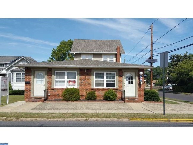
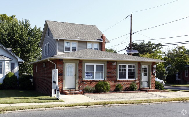
Property Record
75 E Browning Rd, Bellmawr, NJ 08031

Property Detail
75 E Browning Rd
Philadelphia-Camden-Wilmington, PA-NJ-DE-MD
Camden
04-00095-0000-00014
New Jersey
Commercialnec
14
B and X Area of moderate flood hazard, usually the area between the limits of the 100-year and 500-year floods.
0.07 AC
2025
North Camden County
2025
Philadelphia
606800
NEARBY LISTINGS FOR SALE OR LEASE
DEMOGRAPHICS near 75 E Browning Rd
1 mile
3 mile
5 mile
2024 Total Population
14,015
108,220
281,493
2029 Population
14,211
109,926
287,768
Pop Growth 2024-2029
+ 1.40%
+ 1.58%
+ 2.23%
Average Age
42
41
40
2024 Total Households
5,633
44,378
112,955
HH Growth 2024-2029
+ 1.40%
+ 1.59%
+ 2.21%
Median Household Inc
$97,327
$92,845
$86,455
Avg Household Size
2.40
2.40
2.40
2024 Avg HH Vehicles
2.00
2.00
2.00
Median Home Value
$285,439
$287,735
$291,221
Median Year Built
1956
1956
1959
Nearby Places
Map Layers
Map Styles
 Street
 Aerial
Transit
 Traffic
 Biking
Places
Listings with unknown addresses are not visible on the map
- Restaurants
- Banks
- Shops
- Fitness
- Groceries
PUBLIC TRANSPORTATION
COMMUTER RAIL
Lindenwold (NJT) (Atlantic City Line - NJ Transit Commuter Rail (NJ Transit))
Drive
Walk
Distance
Lindenwold (NJT) (Atlantic City Line - NJ Transit Commuter Rail (NJ Transit))
10 min
5.5 mi
Cherry Hill (Atlantic City Line - NJ Transit Commuter Rail (NJ Transit))
Drive
Walk
Distance
Cherry Hill (Atlantic City Line - NJ Transit Commuter Rail (NJ Transit))
13 min
6.9 mi
AIRPORT
Philadelphia International
Drive
Walk
Distance
Philadelphia International
25 min
13.7 mi
Trenton Mercer
Drive
Walk
Distance
Trenton Mercer
57 min
42.5 mi
Atlantic City International
Drive
Walk
Distance
Atlantic City International
77 min
44.0 mi
Freight Ports
Broadway Terminal - Pier 5
Drive
Walk
Distance
Broadway Terminal - Pier 5
9 min
5.2 mi
SALE & LEASE HISTORY
LISTING DATE
SALE/LEASE

Sep 24, 2016
For Sale
May 26, 2017
For Lease
Jan 24, 2017
For Sale
Feb 03, 2017
For Sale
Nearby Properties
Address
Land Use
TOTAL SIZE
Lot Size
Zoning
Address
Land Use
TOTAL SIZE
Lot Size
Zoning
23.41 AC
BC2
Address
Land Use
TOTAL SIZE
Lot Size
Zoning
Address
Land Use
TOTAL SIZE
Lot Size
Zoning
30.63 AC
R10
Address
Land Use
TOTAL SIZE
Lot Size
Zoning
16,872 SF
RH
Address
Land Use
TOTAL SIZE
Lot Size
Zoning
39,080 SF
18.60 AC
C2
Address
Land Use
TOTAL SIZE
Lot Size
Zoning
1.48 AC
PCR
Address
Land Use
TOTAL SIZE
Lot Size
Zoning
35 AC
R1
Address
Land Use
TOTAL SIZE
Lot Size
Zoning
14.11 AC
RG
Address
Land Use
TOTAL SIZE
Lot Size
Zoning
12.68 AC
RG
Address
Land Use
TOTAL SIZE
Lot Size
Zoning
Address
Land Use
TOTAL SIZE
Lot Size
Zoning
16,796 SF
RH
Address
Land Use
TOTAL SIZE
Lot Size
Zoning
50,464 SF
20.22 AC
RH
Address
Land Use
TOTAL SIZE
Lot Size
Zoning
34.62 AC
Address
Land Use
TOTAL SIZE
Lot Size
Zoning
78.64 AC
Address
Land Use
TOTAL SIZE
Lot Size
Zoning
25.77 AC
R10
Address
Land Use
TOTAL SIZE
Lot Size
Zoning
27.25 AC
Address
Land Use
TOTAL SIZE
Lot Size
Zoning
67.33 AC
BC2
Address
Land Use
TOTAL SIZE
Lot Size
Zoning
Address
Land Use
TOTAL SIZE
Lot Size
Zoning
Address
Land Use
TOTAL SIZE
Lot Size
Zoning
8.18 AC
Address
Land Use
TOTAL SIZE
Lot Size
Zoning
41.09 AC
Address
Land Use
TOTAL SIZE
Lot Size
Zoning
Address
Land Use
TOTAL SIZE
Lot Size
Zoning
Address
Land Use
TOTAL SIZE
Lot Size
Zoning
Address
Land Use
TOTAL SIZE
Lot Size
Zoning
3.50 AC
Address
Land Use
TOTAL SIZE
Lot Size
Zoning
2,560 SF
167.08 AC
ROC
Address
Land Use
TOTAL SIZE
Lot Size
Zoning
16.84 AC
Address
Land Use
TOTAL SIZE
Lot Size
Zoning
Address
Land Use
TOTAL SIZE
Lot Size
Zoning
17.27 AC
Address
Land Use
TOTAL SIZE
Lot Size
Zoning
14.49 AC
BC2
The World's #1 Commercial Real Estate Marketplace
Connect with us
© 2026 CoStar Group
The information above has been obtained from sources believed reliable. While we do not doubt its accuracy we have not verified it and make no guarantee, warranty or representation about it. It is your responsibility to independently confirm its accuracy and completeness. Any projections, opinions, assumptions, or estimates used are for example only and do not represent the current or future performance of the property. The value of this transaction to you depends on tax and other factors which should be evaluated by your tax, financial, and legal advisors. You and your advisors should conduct a careful, independent investigation of the property to determine to your satisfaction the suitability of the property for your needs.