Property Record
75 Highway 78, Monroe, GA 30655
NEARBY LISTINGS FOR SALE OR LEASE
-
-
View all Monroe listings for sale on LoopNet.com
Property Detail
75 Highway 78
Atlanta-Sandy Springs-Roswell, GA
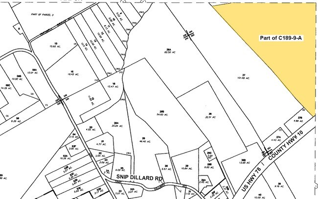
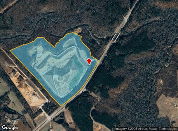
09614-Landfill C&D
C189000000009A00
159.917AC
Industrialgeneral
Walton
A
Georgia
13297C0065E
253
2024
159.92 AC
2025
Walton County
110200
Atlanta
1,680 SF
DEMOGRAPHICS near 75 Highway 78
1 Mile
3 Mile
5 Mile
2024 Total Population
108
3,924
16,716
2029 Population
123
4,434
19,096
Pop Growth 2024-2029
+ 13.89%
+ 13.00%
+ 14.24%
Average Age
39
38
39
2024 Total Households
36
1,310
5,714
HH Growth 2024-2029
+ 16.67%
+ 13.36%
+ 14.61%
Median Household Inc
$74,999
$84,632
$101,799
Avg Household Size
2.90
3.00
2.90
2024 Avg HH Vehicles
2.00
2.00
2.00
Median Home Value
$366,666
$376,157
$353,894
Median Year Built
1998
2001
2003
Nearby Places
Map Layers
Map Styles
 Street
 Aerial
- Restaurants
- Banks
- Shops
- Fitness
- Groceries
Nearby Properties
Address
Land Use
TOTAL SIZE
Lot Size
Zoning
Address
Land Use
TOTAL SIZE
Lot Size
Zoning
87,278 SF
43.43 AC
A-1
Address
Land Use
TOTAL SIZE
Lot Size
Zoning
Address
Land Use
TOTAL SIZE
Lot Size
Zoning
337.25 AC
AR
Address
Land Use
TOTAL SIZE
Lot Size
Zoning
136.40 AC
R-1
Address
Land Use
TOTAL SIZE
Lot Size
Zoning
11,200 SF
14.02 AC
AG
Address
Land Use
TOTAL SIZE
Lot Size
Zoning
216.33 AC
AG
Address
Land Use
TOTAL SIZE
Lot Size
Zoning
9,036 SF
14.50 AC
AG
Address
Land Use
TOTAL SIZE
Lot Size
Zoning
233.19 AC
AG
Address
Land Use
TOTAL SIZE
Lot Size
Zoning
140.13 AC
AG
Address
Land Use
TOTAL SIZE
Lot Size
Zoning
155.94 AC
AG
Address
Land Use
TOTAL SIZE
Lot Size
Zoning
109.23 AC
R-1-MPD
Address
Land Use
TOTAL SIZE
Lot Size
Zoning
381.19 AC
A1
Address
Land Use
TOTAL SIZE
Lot Size
Zoning
171.47 AC
AG
Address
Land Use
TOTAL SIZE
Lot Size
Zoning
15,626 SF
4.90 AC
B-1
Address
Land Use
TOTAL SIZE
Lot Size
Zoning
42.90 AC
B-1
Address
Land Use
TOTAL SIZE
Lot Size
Zoning
127.46 AC
AG
Address
Land Use
TOTAL SIZE
Lot Size
Zoning
116.44 AC
AG
Address
Land Use
TOTAL SIZE
Lot Size
Zoning
84.72 AC
AG
Address
Land Use
TOTAL SIZE
Lot Size
Zoning
86.08 AC
R-1-MPD
Address
Land Use
TOTAL SIZE
Lot Size
Zoning
8,195 SF
49.86 AC
A-1
Address
Land Use
TOTAL SIZE
Lot Size
Zoning
3,498 SF
89.27 AC
AG
Address
Land Use
TOTAL SIZE
Lot Size
Zoning
2,858 SF
43.57 AC
AG
Address
Land Use
TOTAL SIZE
Lot Size
Zoning
56.84 AC
AG
Address
Land Use
TOTAL SIZE
Lot Size
Zoning
80.95 AC
AG
Address
Land Use
TOTAL SIZE
Lot Size
Zoning
39.28 AC
A-1
Address
Land Use
TOTAL SIZE
Lot Size
Zoning
73.54 AC
AG
Address
Land Use
TOTAL SIZE
Lot Size
Zoning
70.83 AC
AG
Address
Land Use
TOTAL SIZE
Lot Size
Zoning
68.48 AC
AG
Address
Land Use
TOTAL SIZE
Lot Size
Zoning
61.24 AC
AG
The World's #1 Commercial Real Estate Marketplace
Connect with us
© 2026 CoStar Group
The information above has been obtained from sources believed reliable. While we do not doubt its accuracy we have not verified it and make no guarantee, warranty or representation about it. It is your responsibility to independently confirm its accuracy and completeness. Any projections, opinions, assumptions, or estimates used are for example only and do not represent the current or future performance of the property. The value of this transaction to you depends on tax and other factors which should be evaluated by your tax, financial, and legal advisors. You and your advisors should conduct a careful, independent investigation of the property to determine to your satisfaction the suitability of the property for your needs.