Property Record
75 Maple Ave, Catskill, NY 12414
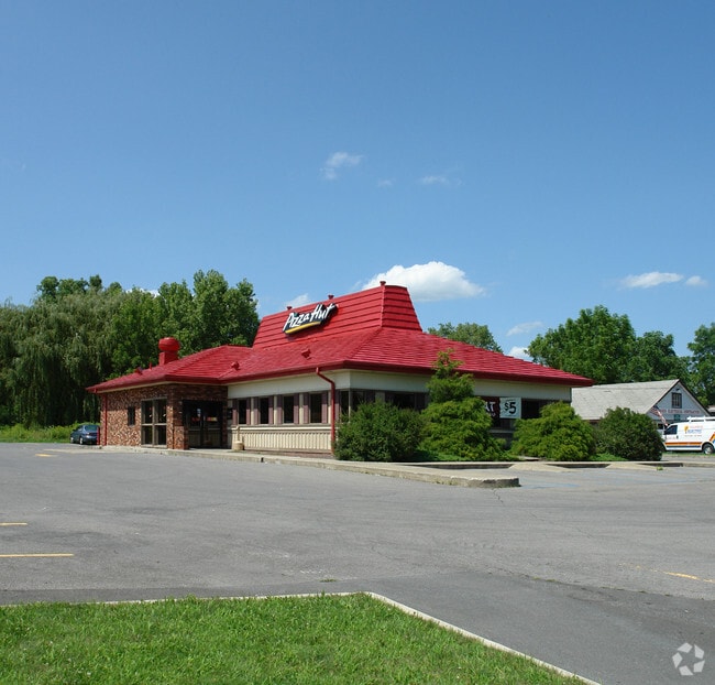

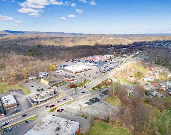
Property Detail
75 Maple Ave
Restaurantdrivein
Greene
03 - MULTI
New York
B and X Area of moderate flood hazard, usually the area between the limits of the 100-year and 500-year floods.
36.000
2025
0.73 AC
2025
Greene County
081001
Albany/Schenectady/Troy
3,016 SF
192601-156-017-0005-036-000-0000
NEARBY LISTINGS FOR SALE OR LEASE
DEMOGRAPHICS near 75 Maple Ave
1 mile
3 mile
5 mile
2025 Total Population
4,529
6,813
14,343
2030 Population
4,417
6,635
14,081
Pop Growth 2025-2030
(2.47%)
(2.61%)
(1.83%)
Average Age
44
45
45
2025 Total Households
2,106
3,093
6,529
HH Growth 2025-2030
(2.18%)
(2.30%)
(1.65%)
Median Household Inc
$68,307
$68,087
$62,757
Avg Household Size
2.00
2.10
2.10
2025 Avg HH Vehicles
1.00
2.00
2.00
Median Home Value
$268,518
$266,028
$288,194
Median Year Built
1947
1948
1953
Nearby Places
Map Layers
Map Styles
 Street
 Aerial
Layers
 Traffic
 Biking
Places
Listings with unknown addresses are not visible on the map
- Restaurants
- Banks
- Shops
- Fitness
- Groceries
PUBLIC TRANSPORTATION
COMMUTER RAIL
Drive
Walk
Distance
14 min
6.7 mi
SALE & LEASE HISTORY
LISTING DATE
SALE/LEASE

Sep 11, 2023
For Sale
Apr 11, 2024
For Sale
Nearby Properties
Address
Land Use
TOTAL SIZE
Lot Size
Zoning
Address
Land Use
TOTAL SIZE
Lot Size
Zoning
142,680 SF
44.44 AC
06 - INDUS
Address
Land Use
TOTAL SIZE
Lot Size
Zoning
146,288 SF
17.80 AC
01 - NOT Z
Address
Land Use
TOTAL SIZE
Lot Size
Zoning
108,000 SF
1.30 AC
05 - COMME
Address
Land Use
TOTAL SIZE
Lot Size
Zoning
217,226 SF
19.20 AC
02 - SINGL
Address
Land Use
TOTAL SIZE
Lot Size
Zoning
175,908 SF
31.10 AC
03 - MULTI
Address
Land Use
TOTAL SIZE
Lot Size
Zoning
14,591 SF
252 AC
9
Address
Land Use
TOTAL SIZE
Lot Size
Zoning
63,071 SF
8.08 AC
02 - SINGL
Address
Land Use
TOTAL SIZE
Lot Size
Zoning
5,165 SF
100.51 AC
01 - NOT Z
Address
Land Use
TOTAL SIZE
Lot Size
Zoning
120,765 SF
5.34 AC
05 - COMME
Address
Land Use
TOTAL SIZE
Lot Size
Zoning
139,410 SF
12.96 AC
02 - SINGL
Address
Land Use
TOTAL SIZE
Lot Size
Zoning
103,792 SF
25.84 AC
02 - SINGL
Address
Land Use
TOTAL SIZE
Lot Size
Zoning
Address
Land Use
TOTAL SIZE
Lot Size
Zoning
Address
Land Use
TOTAL SIZE
Lot Size
Zoning
64,420 SF
3.80 AC
05 - COMME
Address
Land Use
TOTAL SIZE
Lot Size
Zoning
13,900 SF
11.50 AC
02 - SINGL
Address
Land Use
TOTAL SIZE
Lot Size
Zoning
Address
Land Use
TOTAL SIZE
Lot Size
Zoning
10.88 AC
02 - SINGL
Address
Land Use
TOTAL SIZE
Lot Size
Zoning
Address
Land Use
TOTAL SIZE
Lot Size
Zoning
Address
Land Use
TOTAL SIZE
Lot Size
Zoning
24,846 SF
18.50 AC
10
Address
Land Use
TOTAL SIZE
Lot Size
Zoning
42,664 SF
2.91 AC
05 - COMME
Address
Land Use
TOTAL SIZE
Lot Size
Zoning
18,250 SF
1.24 AC
05 - COMME
Address
Land Use
TOTAL SIZE
Lot Size
Zoning
1,632 SF
14.22 AC
01 - NOT Z
Address
Land Use
TOTAL SIZE
Lot Size
Zoning
Address
Land Use
TOTAL SIZE
Lot Size
Zoning
15,564 SF
10 AC
10
Address
Land Use
TOTAL SIZE
Lot Size
Zoning
14,550 SF
1.80 AC
02 - SINGL
Address
Land Use
TOTAL SIZE
Lot Size
Zoning
6,188 SF
4.84 AC
9
Address
Land Use
TOTAL SIZE
Lot Size
Zoning
20,000 SF
2.61 AC
02 - SINGL
Address
Land Use
TOTAL SIZE
Lot Size
Zoning
49,485 SF
5.60 AC
05 - COMME
Address
Land Use
TOTAL SIZE
Lot Size
Zoning
23,103 SF
3.63 AC
05 - COMME
The World's #1 Commercial Real Estate Marketplace
Connect with us
© 2026 CoStar Group
The information above has been obtained from sources believed reliable. While we do not doubt its accuracy we have not verified it and make no guarantee, warranty or representation about it. It is your responsibility to independently confirm its accuracy and completeness. Any projections, opinions, assumptions, or estimates used are for example only and do not represent the current or future performance of the property. The value of this transaction to you depends on tax and other factors which should be evaluated by your tax, financial, and legal advisors. You and your advisors should conduct a careful, independent investigation of the property to determine to your satisfaction the suitability of the property for your needs.