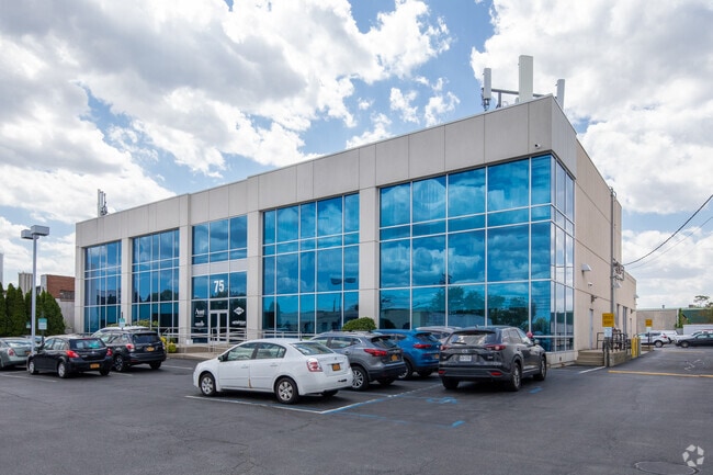
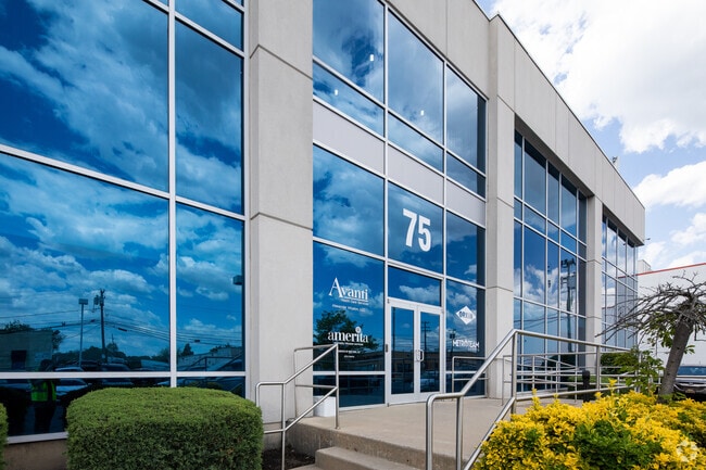
Property Record
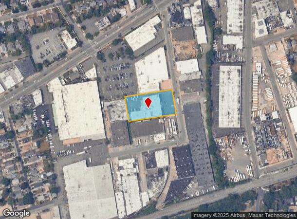
75 Nassau Terminal Rd, New Hyde Park, NY 11040

NEARBY LISTINGS FOR SALE OR LEASE
Property Detail
75 Nassau Terminal Rd
2289-33-K-00-0304-0
TOWN #2 SCH DIST 005
Officebuilding
Nassau
X
New York
36059C0210G
304
2025
1.04 AC
2025
Western Nassau
302900
Long Island (New York)
34,110 SF
Nassau County-Suffolk County, NY
DEMOGRAPHICS near 75 Nassau Terminal Rd
1 Mile
3 Mile
5 Mile
2024 Total Population
24,618
232,095
636,768
2029 Population
24,172
225,095
614,049
Pop Growth 2024-2029
(1.81%)
(3.02%)
(3.57%)
Average Age
42
43
42
2024 Total Households
7,713
78,007
205,632
HH Growth 2024-2029
(1.96%)
(3.11%)
(3.77%)
Median Household Inc
$143,550
$122,349
$113,247
Avg Household Size
3.10
2.90
3.00
2024 Avg HH Vehicles
2.00
2.00
2.00
Median Home Value
$769,553
$724,490
$690,319
Median Year Built
1950
1952
1952
Nearby Places
- Restaurants
- Banks
- Shops
- Fitness
- Groceries
PUBLIC TRANSPORTATION
TRANSIT/SUBWAY
New Hyde Park Station (Port Jefferson Branch - Long Island Rail Road)
DRIVE
WALK
Distance
New Hyde Park Station (Port Jefferson Branch - Long Island Rail Road)
2 min
13 min
0.7 mi
Merillon Avenue Station (Port Jefferson Branch - Long Island Rail Road)
DRIVE
WALK
Distance
Merillon Avenue Station (Port Jefferson Branch - Long Island Rail Road)
3 min
18 min
0.9 mi
COMMUTER RAIL
New Hyde Park Station (Port Jefferson Branch - Long Island Rail Road)
DRIVE
WALK
Distance
New Hyde Park Station (Port Jefferson Branch - Long Island Rail Road)
2 min
14 min
0.7 mi
Merillon Avenue Station (Port Jefferson Branch - Long Island Rail Road)
DRIVE
WALK
Distance
Merillon Avenue Station (Port Jefferson Branch - Long Island Rail Road)
3 min
18 min
0.9 mi
AIRPORT
John F Kennedy International
DRIVE
WALK
Distance
John F Kennedy International
21 min
11.9 mi
LaGuardia
DRIVE
WALK
Distance
LaGuardia
24 min
13.6 mi
Westchester County
DRIVE
WALK
Distance
Westchester County
53 min
35.1 mi
Freight Ports
NY - Red Hook Container Terminal
DRIVE
WALK
Distance
NY - Red Hook Container Terminal
36 min
21.8 mi
SALE & LEASE HISTORY
LISTING DATE
SALE/LEASE

Oct 26, 2021
For Sale
Jul 15, 2020
For Lease
Apr 26, 2022
For Lease
Apr 26, 2022
For Sale
Nearby Properties
Address
Land Use
TOTAL SIZE
Lot Size
Zoning
Address
Land Use
TOTAL SIZE
Lot Size
Zoning
1,667,567 SF
30 AC
R3-2
Address
Land Use
TOTAL SIZE
Lot Size
Zoning
202,459 SF
82.16 AC
R3-2
Address
Land Use
TOTAL SIZE
Lot Size
Zoning
201,770 SF
7.09 AC
R3-2
Address
Land Use
TOTAL SIZE
Lot Size
Zoning
7,030 SF
12.43 AC
R3-2
Address
Land Use
TOTAL SIZE
Lot Size
Zoning
111,122 SF
8.94 AC
R3-2
Address
Land Use
TOTAL SIZE
Lot Size
Zoning
123,832 SF
5.29 AC
R3-2
Address
Land Use
TOTAL SIZE
Lot Size
Zoning
231,865 SF
9.99 AC
C4-1
Address
Land Use
TOTAL SIZE
Lot Size
Zoning
356,093 SF
3 AC
R3-2
Address
Land Use
TOTAL SIZE
Lot Size
Zoning
171,000 SF
2.76 AC
R2A
Address
Land Use
TOTAL SIZE
Lot Size
Zoning
161,500 SF
3.44 AC
R3-2
Address
Land Use
TOTAL SIZE
Lot Size
Zoning
43,190 SF
6.64 AC
R3-2
Address
Land Use
TOTAL SIZE
Lot Size
Zoning
1,020 SF
12.33 AC
R3-2
Address
Land Use
TOTAL SIZE
Lot Size
Zoning
441,908 SF
13.41 AC
R3-2
Address
Land Use
TOTAL SIZE
Lot Size
Zoning
70,734 SF
2.94 AC
R2A
Address
Land Use
TOTAL SIZE
Lot Size
Zoning
90,974 SF
1.73 AC
R2A
Address
Land Use
TOTAL SIZE
Lot Size
Zoning
108,051 SF
0.96 AC
C8-1
Address
Land Use
TOTAL SIZE
Lot Size
Zoning
53,700 SF
2.92 AC
R4-1
Address
Land Use
TOTAL SIZE
Lot Size
Zoning
65,412 SF
3.31 AC
R3-2
Address
Land Use
TOTAL SIZE
Lot Size
Zoning
59,426 SF
0.65 AC
C8-1
Address
Land Use
TOTAL SIZE
Lot Size
Zoning
13,800 SF
6.43 AC
R3-2
Address
Land Use
TOTAL SIZE
Lot Size
Zoning
35,000 SF
2.16 AC
R3-2
Address
Land Use
TOTAL SIZE
Lot Size
Zoning
42,516 SF
R3-2
Address
Land Use
TOTAL SIZE
Lot Size
Zoning
57,000 SF
2.16 AC
R2A
Address
Land Use
TOTAL SIZE
Lot Size
Zoning
36,500 SF
2 AC
R2A
Address
Land Use
TOTAL SIZE
Lot Size
Zoning
5,322,666 SF
86.10 AC
Address
Land Use
TOTAL SIZE
Lot Size
Zoning
36,667 SF
2.65 AC
C8-1
Address
Land Use
TOTAL SIZE
Lot Size
Zoning
1,867,677 SF
385.47 AC
Address
Land Use
TOTAL SIZE
Lot Size
Zoning
8,998 SF
0.73 AC
R2A
Address
Land Use
TOTAL SIZE
Lot Size
Zoning
2.95 AC
PARK
Address
Land Use
TOTAL SIZE
Lot Size
Zoning
1,511 SF
3.21 AC
PARK
The World's #1 Commercial Real Estate Marketplace
Connect with us
© 2025 CoStar Group
The information above has been obtained from sources believed reliable. While we do not doubt its accuracy we have not verified it and make no guarantee, warranty or representation about it. It is your responsibility to independently confirm its accuracy and completeness. Any projections, opinions, assumptions, or estimates used are for example only and do not represent the current or future performance of the property. The value of this transaction to you depends on tax and other factors which should be evaluated by your tax, financial, and legal advisors. You and your advisors should conduct a careful, independent investigation of the property to determine to your satisfaction the suitability of the property for your needs.