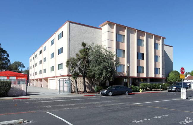
Property Record
75 Perry St, Redwood City, CA 94063

NEARBY LISTINGS FOR SALE OR LEASE
Property Detail
75 Perry St
San Francisco-Redwood City-South San Francisco, CA
Villa Lots
052-321-250
HAVING 175.03 FT FRONT ON PERRY ST COM 100.99 FT FM BREWSTER AVE BEING PTN OF LOT A PERRYS SUB OF VILLA LOTS RSM 11/67 68
Multifamilydwelling
San Mateo
X
California
06081C0301F
a
2024
0.63 AC
2025
Downtown Redwood City
610202
San Francisco
41,648 SF
DEMOGRAPHICS near 75 Perry St
1 Mile
3 Mile
5 Mile
2024 Total Population
28,951
128,861
256,605
2029 Population
27,886
123,264
245,320
Pop Growth 2024-2029
(3.68%)
(4.34%)
(4.40%)
Average Age
38
41
41
2024 Total Households
11,148
46,132
94,209
HH Growth 2024-2029
(3.53%)
(4.40%)
(4.50%)
Median Household Inc
$124,844
$146,827
$159,262
Avg Household Size
2.50
2.70
2.60
2024 Avg HH Vehicles
2.00
2.00
2.00
Median Home Value
$1,121,187
$1,131,052
$1,132,765
Median Year Built
1967
1963
1967
Nearby Places
Map Layers
Map Styles
 Street
 Aerial
- Restaurants
- Banks
- Shops
- Fitness
- Groceries
PUBLIC TRANSPORTATION
COMMUTER RAIL
Redwood City (Caltrain - Caltrain (Caltrain), Express - Caltrain (Caltrain), Limited - Caltrain (Caltrain), Local Weekday - Caltrain (Caltrain), Local Weekend - Caltrain (Caltrain))
DRIVE
WALK
Distance
Redwood City (Caltrain - Caltrain (Caltrain), Express - Caltrain (Caltrain), Limited - Caltrain (Caltrain), Local Weekday - Caltrain (Caltrain), Local Weekend - Caltrain (Caltrain))
1 min
4 min
0.2 mi
San Carlos (Caltrain - Caltrain (Caltrain), Local Weekday - Caltrain (Caltrain), Local Weekend - Caltrain (Caltrain))
DRIVE
WALK
Distance
San Carlos (Caltrain - Caltrain (Caltrain), Local Weekday - Caltrain (Caltrain), Local Weekend - Caltrain (Caltrain))
5 min
2.1 mi
AIRPORT
San Francisco International
DRIVE
WALK
Distance
San Francisco International
20 min
14.2 mi
Norman Y Mineta San Jose International
DRIVE
WALK
Distance
Norman Y Mineta San Jose International
27 min
20.1 mi
Metro Oakland International
DRIVE
WALK
Distance
Metro Oakland International
38 min
29.9 mi
Freight Ports
Port of Redwood City
DRIVE
WALK
Distance
Port of Redwood City
6 min
2.8 mi
Nearby Properties
Address
Land Use
TOTAL SIZE
Lot Size
Zoning
Address
Land Use
TOTAL SIZE
Lot Size
Zoning
373,238 SF
7.94 AC
Address
Land Use
TOTAL SIZE
Lot Size
Zoning
8.31 AC
EA00CA
Address
Land Use
TOTAL SIZE
Lot Size
Zoning
491,030 SF
2.74 AC
Address
Land Use
TOTAL SIZE
Lot Size
Zoning
528,437 SF
9.69 AC
Address
Land Use
TOTAL SIZE
Lot Size
Zoning
330,071 SF
1.64 AC
Address
Land Use
TOTAL SIZE
Lot Size
Zoning
283,015 SF
8.77 AC
Address
Land Use
TOTAL SIZE
Lot Size
Zoning
Address
Land Use
TOTAL SIZE
Lot Size
Zoning
223,321 SF
8.39 AC
M10000
Address
Land Use
TOTAL SIZE
Lot Size
Zoning
Address
Land Use
TOTAL SIZE
Lot Size
Zoning
378,534 SF
2.24 AC
Address
Land Use
TOTAL SIZE
Lot Size
Zoning
283,015 SF
7.66 AC
Address
Land Use
TOTAL SIZE
Lot Size
Zoning
368,000 SF
11.32 AC
Address
Land Use
TOTAL SIZE
Lot Size
Zoning
40,000 SF
1.60 AC
Address
Land Use
TOTAL SIZE
Lot Size
Zoning
190,245 SF
16.88 AC
M10000
Address
Land Use
TOTAL SIZE
Lot Size
Zoning
395,625 SF
5.08 AC
Address
Land Use
TOTAL SIZE
Lot Size
Zoning
458,111 SF
2.26 AC
Address
Land Use
TOTAL SIZE
Lot Size
Zoning
1,849 SF
4.72 AC
CB0000
Address
Land Use
TOTAL SIZE
Lot Size
Zoning
2.69 AC
ML001R
Address
Land Use
TOTAL SIZE
Lot Size
Zoning
366,384 SF
3.63 AC
Address
Land Use
TOTAL SIZE
Lot Size
Zoning
249,198 SF
1.14 AC
Address
Land Use
TOTAL SIZE
Lot Size
Zoning
2,023 SF
1.31 AC
Address
Land Use
TOTAL SIZE
Lot Size
Zoning
262,189 SF
1.16 AC
Address
Land Use
TOTAL SIZE
Lot Size
Zoning
187,781 SF
6.67 AC
CP0000
Address
Land Use
TOTAL SIZE
Lot Size
Zoning
55,422 SF
2.41 AC
PM0002
Address
Land Use
TOTAL SIZE
Lot Size
Zoning
164,732 SF
4.58 AC
Address
Land Use
TOTAL SIZE
Lot Size
Zoning
170,495 SF
7.15 AC
Address
Land Use
TOTAL SIZE
Lot Size
Zoning
Address
Land Use
TOTAL SIZE
Lot Size
Zoning
204,006 SF
9.02 AC
TP0000
Address
Land Use
TOTAL SIZE
Lot Size
Zoning
164,732 SF
7.02 AC
Address
Land Use
TOTAL SIZE
Lot Size
Zoning
141,180 SF
2.41 AC
The World's #1 Commercial Real Estate Marketplace
Connect with us
© 2025 CoStar Group
The information above has been obtained from sources believed reliable. While we do not doubt its accuracy we have not verified it and make no guarantee, warranty or representation about it. It is your responsibility to independently confirm its accuracy and completeness. Any projections, opinions, assumptions, or estimates used are for example only and do not represent the current or future performance of the property. The value of this transaction to you depends on tax and other factors which should be evaluated by your tax, financial, and legal advisors. You and your advisors should conduct a careful, independent investigation of the property to determine to your satisfaction the suitability of the property for your needs.