Property Record
75 S Main St, Sharon, MA 02067


Save to a Folder
{{folder.Name}}
{{folder.ListingIds.length}} Properties
{{folder.ListingIds.length}} Property
Create a New Folder
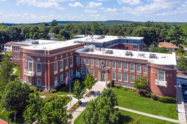
Property Detail
75 S Main St
SHAR-000091-000252
Norfolk
Apartment
Massachusetts
B and X Area of moderate flood hazard, usually the area between the limits of the 100-year and 500-year floods.
2.92 AC
2025
Outer Route 1 South
2025
Boston
414300
Boston-Cambridge-Newton, MA-NH
97,269 SF
NEARBY LISTINGS FOR SALE OR LEASE
-
-
View all Sharon listings for sale on LoopNet.com
DEMOGRAPHICS near 75 S Main St
1 mile
3 mile
5 mile
2025 Total Population
4,606
35,441
116,312
2030 Population
4,725
36,508
119,378
Pop Growth 2025-2030
+ 2.58%
+ 3.01%
+ 2.64%
Average Age
41
43
42
2025 Total Households
1,644
13,461
44,318
HH Growth 2025-2030
+ 2.74%
+ 3.20%
+ 2.77%
Median Household Inc
$182,954
$144,900
$124,365
Avg Household Size
2.80
2.60
2.60
2025 Avg HH Vehicles
2.00
2.00
2.00
Median Home Value
$756,592
$713,571
$707,511
Median Year Built
1954
1972
1969
Nearby Places
Map Layers
Map Styles
 Street
 Aerial
Layers
 Traffic
 Biking
Places
Listings with unknown addresses are not visible on the map
- Restaurants
- Banks
- Shops
- Fitness
- Groceries
PUBLIC TRANSPORTATION
TRANSIT/SUBWAY
Sharon (Providence/Stoughton Line - Massachusetts Bay Transportation Authority Commuter Rail (Purple Line))
Drive
Walk
Distance
Sharon (Providence/Stoughton Line - Massachusetts Bay Transportation Authority Commuter Rail (Purple Line))
3 min
7 min
0.4 mi
COMMUTER RAIL
Sharon (Providence/Stoughton Line - Massachusetts Bay Transportation Authority Commuter Rail (Purple Line))
Drive
Walk
Distance
Sharon (Providence/Stoughton Line - Massachusetts Bay Transportation Authority Commuter Rail (Purple Line))
3 min
9 min
0.4 mi
Canton Center (Providence/Stoughton Line - Massachusetts Bay Transportation Authority Commuter Rail (Purple Line))
Drive
Walk
Distance
Canton Center (Providence/Stoughton Line - Massachusetts Bay Transportation Authority Commuter Rail (Purple Line))
8 min
3.7 mi
AIRPORT
General Edward Lawrence Logan International
Drive
Walk
Distance
General Edward Lawrence Logan International
42 min
22.3 mi
Rhode Island Tf Green International
Drive
Walk
Distance
Rhode Island Tf Green International
53 min
34.9 mi
Freight Ports
Port of Boston
Drive
Walk
Distance
Port of Boston
39 min
20.0 mi
Nearby Properties
Address
Land Use
TOTAL SIZE
Lot Size
Zoning
Address
Land Use
TOTAL SIZE
Lot Size
Zoning
544,990 SF
63.29 AC
Address
Land Use
TOTAL SIZE
Lot Size
Zoning
56,088 SF
23.94 AC
I
Address
Land Use
TOTAL SIZE
Lot Size
Zoning
30.94 AC
Address
Land Use
TOTAL SIZE
Lot Size
Zoning
1,080 SF
10.07 AC
Address
Land Use
TOTAL SIZE
Lot Size
Zoning
28,561 SF
26.30 AC
Address
Land Use
TOTAL SIZE
Lot Size
Zoning
14.33 AC
Address
Land Use
TOTAL SIZE
Lot Size
Zoning
196,398 SF
28.50 AC
Address
Land Use
TOTAL SIZE
Lot Size
Zoning
103,901 SF
22.21 AC
Address
Land Use
TOTAL SIZE
Lot Size
Zoning
77,791 SF
2.24 AC
3
Address
Land Use
TOTAL SIZE
Lot Size
Zoning
93,218 SF
9.68 AC
LI
Address
Land Use
TOTAL SIZE
Lot Size
Zoning
54,948 SF
11.43 AC
Address
Land Use
TOTAL SIZE
Lot Size
Zoning
107,467 SF
19.59 AC
Address
Land Use
TOTAL SIZE
Lot Size
Zoning
55,182 SF
4.04 AC
Address
Land Use
TOTAL SIZE
Lot Size
Zoning
77,212 SF
2.40 AC
5
Address
Land Use
TOTAL SIZE
Lot Size
Zoning
87,655 SF
3.39 AC
GB
Address
Land Use
TOTAL SIZE
Lot Size
Zoning
56,414 SF
7.63 AC
Address
Land Use
TOTAL SIZE
Lot Size
Zoning
102,024 SF
9.97 AC
LI
Address
Land Use
TOTAL SIZE
Lot Size
Zoning
147,984 SF
20.57 AC
Address
Land Use
TOTAL SIZE
Lot Size
Zoning
1,060 SF
103.22 AC
Address
Land Use
TOTAL SIZE
Lot Size
Zoning
64,689 SF
24.60 AC
5
Address
Land Use
TOTAL SIZE
Lot Size
Zoning
101,171 SF
11.12 AC
LI
Address
Land Use
TOTAL SIZE
Lot Size
Zoning
76,598 SF
14.39 AC
Address
Land Use
TOTAL SIZE
Lot Size
Zoning
109,094 SF
6.19 AC
Address
Land Use
TOTAL SIZE
Lot Size
Zoning
5.42 AC
RM
Address
Land Use
TOTAL SIZE
Lot Size
Zoning
71,944 SF
5 AC
Address
Land Use
TOTAL SIZE
Lot Size
Zoning
124,519 SF
14.22 AC
LI
Address
Land Use
TOTAL SIZE
Lot Size
Zoning
80,453 SF
10.79 AC
Address
Land Use
TOTAL SIZE
Lot Size
Zoning
317 AC
Address
Land Use
TOTAL SIZE
Lot Size
Zoning
91,982 SF
5.21 AC
The World's #1 Commercial Real Estate Marketplace
Connect with us
© 2026 CoStar Group
The information above has been obtained from sources believed reliable. While we do not doubt its accuracy we have not verified it and make no guarantee, warranty or representation about it. It is your responsibility to independently confirm its accuracy and completeness. Any projections, opinions, assumptions, or estimates used are for example only and do not represent the current or future performance of the property. The value of this transaction to you depends on tax and other factors which should be evaluated by your tax, financial, and legal advisors. You and your advisors should conduct a careful, independent investigation of the property to determine to your satisfaction the suitability of the property for your needs.