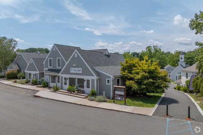
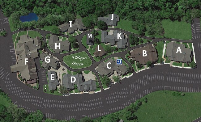
Property Record
75 State Route 15, Lafayette, NJ 07848
NEARBY LISTINGS FOR SALE OR LEASE
Property Detail
75 State Route 15
Newark, NJ-PA
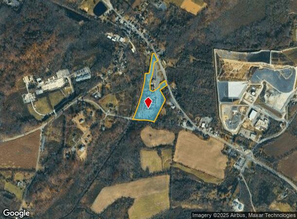
Survey Plat For Olde Lafayette Village L
13-00008-0000-00026-01
Sussex
Storemultistory
New Jersey
X
26.1
34037C0304E
12.33 AC
2024
Sussex County
2025
Northern New Jersey
372400
DEMOGRAPHICS near 75 State Route 15
1 Mile
3 Mile
5 Mile
2024 Total Population
475
4,795
27,765
2029 Population
471
4,839
27,975
Pop Growth 2024-2029
(0.84%)
+ 0.92%
+ 0.76%
Average Age
45
44
43
2024 Total Households
177
1,849
10,449
HH Growth 2024-2029
(0.56%)
+ 0.87%
+ 0.75%
Median Household Inc
$109,210
$104,032
$102,172
Avg Household Size
2.70
2.60
2.50
2024 Avg HH Vehicles
3.00
2.00
2.00
Median Home Value
$411,538
$367,549
$351,961
Median Year Built
1974
1981
1973
Nearby Places
Map Layers
Map Styles
 Street
 Aerial
- Restaurants
- Banks
- Shops
- Fitness
- Groceries
SALE & LEASE HISTORY
LISTING DATE
SALE/LEASE

Sep 24, 2016
For Sale
Jan 05, 2018
For Lease
Aug 22, 2019
For Lease
Nearby Properties
Address
Land Use
TOTAL SIZE
Lot Size
Zoning
Address
Land Use
TOTAL SIZE
Lot Size
Zoning
156,719 SF
48.98 AC
OSGU
Address
Land Use
TOTAL SIZE
Lot Size
Zoning
52.16 AC
HCMF
Address
Land Use
TOTAL SIZE
Lot Size
Zoning
28.91 AC
PVC
Address
Land Use
TOTAL SIZE
Lot Size
Zoning
2.02 AC
PVC
Address
Land Use
TOTAL SIZE
Lot Size
Zoning
2.27 AC
PVC
Address
Land Use
TOTAL SIZE
Lot Size
Zoning
58,605 SF
28.29 AC
OSGU
Address
Land Use
TOTAL SIZE
Lot Size
Zoning
29,156 SF
121.97 AC
L-1
Address
Land Use
TOTAL SIZE
Lot Size
Zoning
58.78 AC
PDRM
Address
Land Use
TOTAL SIZE
Lot Size
Zoning
15,400 SF
53.92 AC
PDRM
Address
Land Use
TOTAL SIZE
Lot Size
Zoning
65,064 SF
7.17 AC
L-1
Address
Land Use
TOTAL SIZE
Lot Size
Zoning
31,620 SF
8.18 AC
HCMF
Address
Land Use
TOTAL SIZE
Lot Size
Zoning
31,504 SF
3.06 AC
ED-1
Address
Land Use
TOTAL SIZE
Lot Size
Zoning
23,184 SF
82.13 AC
OSGU
Address
Land Use
TOTAL SIZE
Lot Size
Zoning
29.26 AC
HCR3
Address
Land Use
TOTAL SIZE
Lot Size
Zoning
10 AC
RR
Address
Land Use
TOTAL SIZE
Lot Size
Zoning
59,919 SF
21.22 AC
R-2
Address
Land Use
TOTAL SIZE
Lot Size
Zoning
45,445 SF
8.65 AC
ED
Address
Land Use
TOTAL SIZE
Lot Size
Zoning
10.16 AC
HCRD
Address
Land Use
TOTAL SIZE
Lot Size
Zoning
11,765 SF
9.45 AC
HCMF
Address
Land Use
TOTAL SIZE
Lot Size
Zoning
6.08 AC
PVC
Address
Land Use
TOTAL SIZE
Lot Size
Zoning
1.21 AC
R-3
Address
Land Use
TOTAL SIZE
Lot Size
Zoning
18,954 SF
7.56 AC
HCMF
Address
Land Use
TOTAL SIZE
Lot Size
Zoning
15,000 SF
2.03 AC
HCMF
Address
Land Use
TOTAL SIZE
Lot Size
Zoning
10.87 AC
L-I
Address
Land Use
TOTAL SIZE
Lot Size
Zoning
23,776 SF
190.85 AC
R1
Address
Land Use
TOTAL SIZE
Lot Size
Zoning
70.27 AC
E-D
Address
Land Use
TOTAL SIZE
Lot Size
Zoning
2.85 AC
L-I
Address
Land Use
TOTAL SIZE
Lot Size
Zoning
12,440 SF
6.55 AC
HCMF
Address
Land Use
TOTAL SIZE
Lot Size
Zoning
8.56 AC
ED
Address
Land Use
TOTAL SIZE
Lot Size
Zoning
4.35 AC
L-I
The World's #1 Commercial Real Estate Marketplace
Connect with us
© 2025 CoStar Group
The information above has been obtained from sources believed reliable. While we do not doubt its accuracy we have not verified it and make no guarantee, warranty or representation about it. It is your responsibility to independently confirm its accuracy and completeness. Any projections, opinions, assumptions, or estimates used are for example only and do not represent the current or future performance of the property. The value of this transaction to you depends on tax and other factors which should be evaluated by your tax, financial, and legal advisors. You and your advisors should conduct a careful, independent investigation of the property to determine to your satisfaction the suitability of the property for your needs.