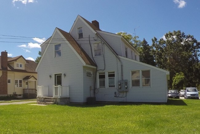
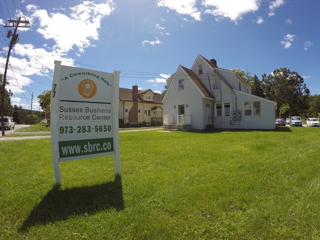
Property Record
75 State Rt 23 N, Hamburg, NJ 07419
Property Detail
75 State Rt 23 N
24-00007-0000-00019
SUSSEX
Shipyard
New Jersey
HWCO
19
B and X Area of moderate flood hazard, usually the area between the limits of the 100-year and 500-year floods.
16.85 AC
2024
Sussex County
2025
Northern New Jersey
372700
Newark, NJ
1,152 SF
NEARBY LISTINGS FOR SALE OR LEASE
DEMOGRAPHICS near 75 State Rt 23 N
1 mile
3 mile
5 mile
2025 Total Population
2,468
16,414
32,959
2030 Population
2,521
16,811
33,796
Pop Growth 2025-2030
+ 2.15%
+ 2.42%
+ 2.54%
Average Age
45
44
44
2025 Total Households
1,086
6,837
13,571
HH Growth 2025-2030
+ 2.12%
+ 2.44%
+ 2.59%
Median Household Inc
$93,355
$100,720
$97,386
Avg Household Size
2.30
2.40
2.40
2025 Avg HH Vehicles
2.00
2.00
2.00
Median Home Value
$332,373
$329,842
$331,642
Median Year Built
1988
1981
1977
Nearby Places
Map Layers
Map Styles
 Street
 Aerial
Layers
 Traffic
 Biking
Places
Listings with unknown addresses are not visible on the map
- Restaurants
- Banks
- Shops
- Fitness
- Groceries
SALE & LEASE HISTORY
LISTING DATE
SALE/LEASE

Nov 10, 2016
For Lease
Nov 01, 2019
For Lease
May 05, 2019
For Lease
Jul 30, 2018
For Lease
Apr 22, 2021
For Lease
Nearby Properties
Address
Land Use
TOTAL SIZE
Lot Size
Zoning
Address
Land Use
TOTAL SIZE
Lot Size
Zoning
68.74 AC
R-C
Address
Land Use
TOTAL SIZE
Lot Size
Zoning
66.06 AC
GC
Address
Land Use
TOTAL SIZE
Lot Size
Zoning
18.69 AC
R-4
Address
Land Use
TOTAL SIZE
Lot Size
Zoning
83.51 AC
TCSC
Address
Land Use
TOTAL SIZE
Lot Size
Zoning
12.80 AC
R-4
Address
Land Use
TOTAL SIZE
Lot Size
Zoning
638 SF
30.12 AC
C-R
Address
Land Use
TOTAL SIZE
Lot Size
Zoning
230.56 AC
B-1
Address
Land Use
TOTAL SIZE
Lot Size
Zoning
0.92 AC
R-5
Address
Land Use
TOTAL SIZE
Lot Size
Zoning
5.90 AC
C-R
Address
Land Use
TOTAL SIZE
Lot Size
Zoning
10 AC
P
Address
Land Use
TOTAL SIZE
Lot Size
Zoning
5.73 AC
LI&U
Address
Land Use
TOTAL SIZE
Lot Size
Zoning
10.29 AC
MID3
Address
Land Use
TOTAL SIZE
Lot Size
Zoning
7.57 AC
NHCO
Address
Land Use
TOTAL SIZE
Lot Size
Zoning
Address
Land Use
TOTAL SIZE
Lot Size
Zoning
10,920 SF
12.47 AC
R-3
Address
Land Use
TOTAL SIZE
Lot Size
Zoning
6 AC
GC
Address
Land Use
TOTAL SIZE
Lot Size
Zoning
1,860 SF
51.68 AC
I-1
Address
Land Use
TOTAL SIZE
Lot Size
Zoning
11.60 AC
HWCO
Address
Land Use
TOTAL SIZE
Lot Size
Zoning
194.75 AC
I-2
Address
Land Use
TOTAL SIZE
Lot Size
Zoning
7.02 AC
TCSC
Address
Land Use
TOTAL SIZE
Lot Size
Zoning
161.70 AC
I
Address
Land Use
TOTAL SIZE
Lot Size
Zoning
8,008 SF
6.88 AC
R-3
Address
Land Use
TOTAL SIZE
Lot Size
Zoning
61,795 SF
7.79 AC
P
Address
Land Use
TOTAL SIZE
Lot Size
Zoning
19.14 AC
I
Address
Land Use
TOTAL SIZE
Lot Size
Zoning
18.80 AC
B-1
Address
Land Use
TOTAL SIZE
Lot Size
Zoning
0.36 AC
R-1
Address
Land Use
TOTAL SIZE
Lot Size
Zoning
20,682 SF
3.79 AC
I-2
Address
Land Use
TOTAL SIZE
Lot Size
Zoning
3.33 AC
C-R
Address
Land Use
TOTAL SIZE
Lot Size
Zoning
5.88 AC
HWCO
The World's #1 Commercial Real Estate Marketplace
Connect with us
© 2026 CoStar Group
The information above has been obtained from sources believed reliable. While we do not doubt its accuracy we have not verified it and make no guarantee, warranty or representation about it. It is your responsibility to independently confirm its accuracy and completeness. Any projections, opinions, assumptions, or estimates used are for example only and do not represent the current or future performance of the property. The value of this transaction to you depends on tax and other factors which should be evaluated by your tax, financial, and legal advisors. You and your advisors should conduct a careful, independent investigation of the property to determine to your satisfaction the suitability of the property for your needs.