Property Record
75 Stonewood Rd, York, PA 17402
NEARBY LISTINGS FOR SALE OR LEASE
-
-
View all York listings for sale on LoopNet.com
Property Detail
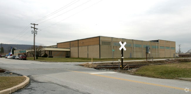
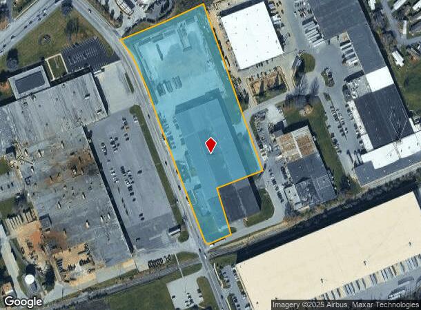
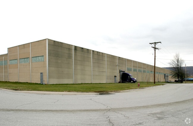
75 Stonewood Rd
Lightindustrial
York
X
Pennsylvania
42133C0332F
6.81 AC
2025
York County
2025
Philadelphia
010130
York-Hanover, PA
111,060 SF
46-000-KJ-0103.00-00000
DEMOGRAPHICS near 75 Stonewood Rd
1 Mile
3 Mile
5 Mile
2024 Total Population
5,411
32,372
80,956
2029 Population
5,547
33,163
83,003
Pop Growth 2024-2029
+ 2.51%
+ 2.44%
+ 2.53%
Average Age
43
43
41
2024 Total Households
1,971
12,327
31,478
HH Growth 2024-2029
+ 2.59%
+ 2.45%
+ 2.55%
Median Household Inc
$74,145
$76,557
$70,490
Avg Household Size
2.50
2.40
2.40
2024 Avg HH Vehicles
2.00
2.00
2.00
Median Home Value
$226,262
$236,167
$214,404
Median Year Built
1975
1979
1972
Nearby Places
- Restaurants
- Banks
- Shops
- Fitness
- Groceries
PUBLIC TRANSPORTATION
AIRPORT
Harrisburg International
DRIVE
WALK
Distance
Harrisburg International
49 min
34.0 mi
Freight Ports
Port of Baltimore
DRIVE
WALK
Distance
Port of Baltimore
86 min
59.1 mi
Nearby Properties
Address
Land Use
TOTAL SIZE
Lot Size
Zoning
Address
Land Use
TOTAL SIZE
Lot Size
Zoning
779,291 SF
95.61 AC
I
Address
Land Use
TOTAL SIZE
Lot Size
Zoning
1,068,680 SF
64.22 AC
I
Address
Land Use
TOTAL SIZE
Lot Size
Zoning
123,796 SF
26.99 AC
CH
Address
Land Use
TOTAL SIZE
Lot Size
Zoning
398,644 SF
50.92 AC
CH
Address
Land Use
TOTAL SIZE
Lot Size
Zoning
271,039 SF
47.69 AC
CH
Address
Land Use
TOTAL SIZE
Lot Size
Zoning
12.15 AC
Address
Land Use
TOTAL SIZE
Lot Size
Zoning
150,082 SF
3.45 AC
Address
Land Use
TOTAL SIZE
Lot Size
Zoning
7.08 AC
FD
Address
Land Use
TOTAL SIZE
Lot Size
Zoning
247,968 SF
22.27 AC
RS
Address
Land Use
TOTAL SIZE
Lot Size
Zoning
9,000 SF
10.80 AC
BI
Address
Land Use
TOTAL SIZE
Lot Size
Zoning
101,698 SF
5.88 AC
BI
Address
Land Use
TOTAL SIZE
Lot Size
Zoning
408,240 SF
14.60 AC
FD
Address
Land Use
TOTAL SIZE
Lot Size
Zoning
57,358 SF
9 AC
NC
Address
Land Use
TOTAL SIZE
Lot Size
Zoning
30,240 SF
12.73 AC
RO
Address
Land Use
TOTAL SIZE
Lot Size
Zoning
111,200 SF
17.06 AC
R1
Address
Land Use
TOTAL SIZE
Lot Size
Zoning
248,472 SF
15.15 AC
R1
Address
Land Use
TOTAL SIZE
Lot Size
Zoning
379,860 SF
18.31 AC
FD
Address
Land Use
TOTAL SIZE
Lot Size
Zoning
74,880 SF
17 AC
RH9
Address
Land Use
TOTAL SIZE
Lot Size
Zoning
97,300 SF
9.20 AC
Address
Land Use
TOTAL SIZE
Lot Size
Zoning
99,509 SF
17.44 AC
BI
Address
Land Use
TOTAL SIZE
Lot Size
Zoning
125,040 SF
3.59 AC
CH
Address
Land Use
TOTAL SIZE
Lot Size
Zoning
56,000 SF
1.29 AC
Address
Land Use
TOTAL SIZE
Lot Size
Zoning
26,444 SF
3.14 AC
CM
Address
Land Use
TOTAL SIZE
Lot Size
Zoning
87,714 SF
16.22 AC
CM
Address
Land Use
TOTAL SIZE
Lot Size
Zoning
264,318 SF
31.40 AC
FD
Address
Land Use
TOTAL SIZE
Lot Size
Zoning
37,188 SF
12.17 AC
CM
Address
Land Use
TOTAL SIZE
Lot Size
Zoning
117,875 SF
13.42 AC
CH
Address
Land Use
TOTAL SIZE
Lot Size
Zoning
25,248 SF
7.43 AC
R1
Address
Land Use
TOTAL SIZE
Lot Size
Zoning
126,710 SF
7.49 AC
CH
Address
Land Use
TOTAL SIZE
Lot Size
Zoning
60,736 SF
12.86 AC
MU
The World's #1 Commercial Real Estate Marketplace
Connect with us
© 2025 CoStar Group
The information above has been obtained from sources believed reliable. While we do not doubt its accuracy we have not verified it and make no guarantee, warranty or representation about it. It is your responsibility to independently confirm its accuracy and completeness. Any projections, opinions, assumptions, or estimates used are for example only and do not represent the current or future performance of the property. The value of this transaction to you depends on tax and other factors which should be evaluated by your tax, financial, and legal advisors. You and your advisors should conduct a careful, independent investigation of the property to determine to your satisfaction the suitability of the property for your needs.