Property Record
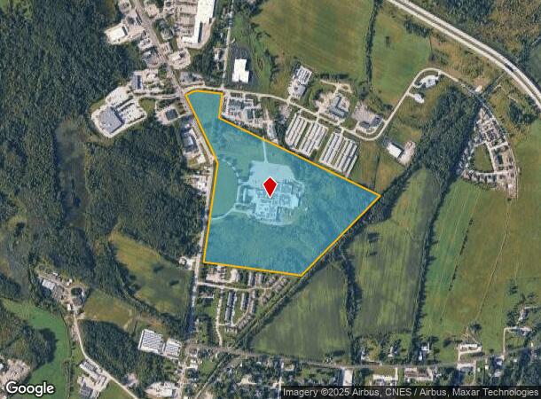
75 Swanton Rd, Saint Albans, VT 05478

NEARBY LISTINGS FOR SALE OR LEASE
-
-
View all Saint Albans listings for sale on LoopNet.com
Property Detail
75 Swanton Rd
Burlington-South Burlington, VT
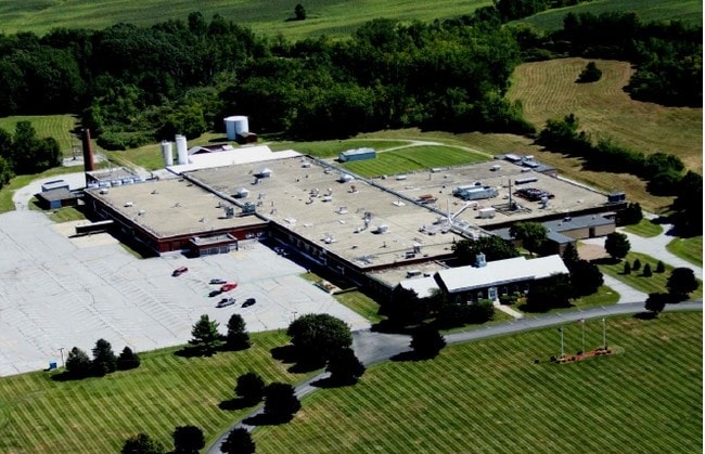
64.64A-INDUS BLDG(FORMER EVEREADY PLANT)
552-174-10923
Franklin
Foundry
Vermont
2021
64.64 AC
2024
Other Market Areas
010600
DEMOGRAPHICS near 75 Swanton Rd
1 Mile
3 Mile
5 Mile
2024 Total Population
1,292
12,983
16,860
2029 Population
1,348
13,579
17,612
Pop Growth 2024-2029
+ 4.33%
+ 4.59%
+ 4.46%
Average Age
42
41
41
2024 Total Households
540
5,530
7,043
HH Growth 2024-2029
+ 4.26%
+ 4.52%
+ 4.40%
Median Household Inc
$64,881
$65,379
$70,281
Avg Household Size
2.30
2.20
2.30
2024 Avg HH Vehicles
2.00
2.00
2.00
Median Home Value
$259,931
$256,632
$270,479
Median Year Built
1968
1972
1977
Nearby Places
Map Layers
Map Styles
 Street
 Aerial
- Restaurants
- Banks
- Shops
- Fitness
- Groceries
PUBLIC TRANSPORTATION
COMMUTER RAIL
St. Albans Amtrak Station (Vermonter - Amtrak)
DRIVE
WALK
Distance
St. Albans Amtrak Station (Vermonter - Amtrak)
3 min
1.6 mi
AIRPORT
Patrick Leahy Burlington International
DRIVE
WALK
Distance
Patrick Leahy Burlington International
45 min
29.5 mi
Freight Ports
Montreal
DRIVE
WALK
Distance
Montreal
91 min
68.9 mi
Nearby Properties
Address
Land Use
TOTAL SIZE
Lot Size
Zoning
Address
Land Use
TOTAL SIZE
Lot Size
Zoning
10.45 AC
Address
Land Use
TOTAL SIZE
Lot Size
Zoning
3.50 AC
Address
Land Use
TOTAL SIZE
Lot Size
Zoning
8.73 AC
Address
Land Use
TOTAL SIZE
Lot Size
Zoning
Address
Land Use
TOTAL SIZE
Lot Size
Zoning
8.03 AC
Address
Land Use
TOTAL SIZE
Lot Size
Zoning
Address
Land Use
TOTAL SIZE
Lot Size
Zoning
3.53 AC
Address
Land Use
TOTAL SIZE
Lot Size
Zoning
154,801 SF
52.16 AC
Address
Land Use
TOTAL SIZE
Lot Size
Zoning
154,260 SF
19.30 AC
Address
Land Use
TOTAL SIZE
Lot Size
Zoning
Address
Land Use
TOTAL SIZE
Lot Size
Zoning
Address
Land Use
TOTAL SIZE
Lot Size
Zoning
3.93 AC
Address
Land Use
TOTAL SIZE
Lot Size
Zoning
45,136 SF
0.29 AC
Address
Land Use
TOTAL SIZE
Lot Size
Zoning
1.87 AC
Address
Land Use
TOTAL SIZE
Lot Size
Zoning
51,309 SF
0.37 AC
Address
Land Use
TOTAL SIZE
Lot Size
Zoning
Address
Land Use
TOTAL SIZE
Lot Size
Zoning
41,256 SF
4.76 AC
Address
Land Use
TOTAL SIZE
Lot Size
Zoning
41,256 SF
4.76 AC
Address
Land Use
TOTAL SIZE
Lot Size
Zoning
Address
Land Use
TOTAL SIZE
Lot Size
Zoning
0.66 AC
Address
Land Use
TOTAL SIZE
Lot Size
Zoning
Address
Land Use
TOTAL SIZE
Lot Size
Zoning
Address
Land Use
TOTAL SIZE
Lot Size
Zoning
51.80 AC
Address
Land Use
TOTAL SIZE
Lot Size
Zoning
Address
Land Use
TOTAL SIZE
Lot Size
Zoning
9.79 AC
Address
Land Use
TOTAL SIZE
Lot Size
Zoning
Address
Land Use
TOTAL SIZE
Lot Size
Zoning
14.07 AC
Address
Land Use
TOTAL SIZE
Lot Size
Zoning
22,065 SF
17.62 AC
Address
Land Use
TOTAL SIZE
Lot Size
Zoning
64.64 AC
The World's #1 Commercial Real Estate Marketplace
Connect with us
© 2025 CoStar Group
The information above has been obtained from sources believed reliable. While we do not doubt its accuracy we have not verified it and make no guarantee, warranty or representation about it. It is your responsibility to independently confirm its accuracy and completeness. Any projections, opinions, assumptions, or estimates used are for example only and do not represent the current or future performance of the property. The value of this transaction to you depends on tax and other factors which should be evaluated by your tax, financial, and legal advisors. You and your advisors should conduct a careful, independent investigation of the property to determine to your satisfaction the suitability of the property for your needs.