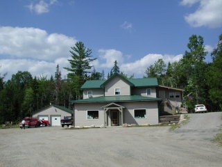
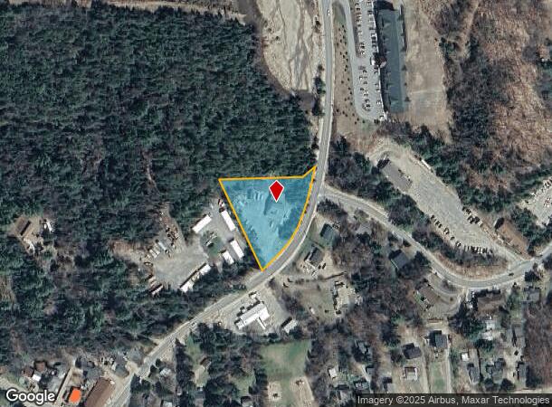
Property Record
75 Wesvalley Rd, Lake Placid, NY 12946
NEARBY LISTINGS FOR SALE OR LEASE
-
-
View all Lake Placid listings for sale on LoopNet.com
Property Detail
75 Wesvalley Rd
Other Market Areas
259 OMT TWP 11 RS SURVEY 5096
154089-042-002-0003-004-200-0000
Essex
Commercialofficeresidentialmixeduse
New York
2024
4.200
2024
1.39 AC
960501
Upstate New York Area
4,600 SF
DEMOGRAPHICS near 75 Wesvalley Rd
1 Mile
3 Mile
5 Mile
2024 Total Population
4,141
6,790
7,079
2029 Population
4,272
7,005
7,296
Pop Growth 2024-2029
+ 3.16%
+ 3.17%
+ 3.07%
Average Age
44
44
44
2024 Total Households
2,027
3,095
3,207
HH Growth 2024-2029
+ 3.50%
+ 3.65%
+ 3.52%
Median Household Inc
$68,490
$73,255
$73,924
Avg Household Size
1.90
1.90
2.00
2024 Avg HH Vehicles
1.00
2.00
2.00
Median Home Value
$396,153
$389,413
$392,674
Median Year Built
1980
1981
1981
Nearby Places
Map Layers
Map Styles
 Street
 Aerial
- Restaurants
- Banks
- Shops
- Fitness
- Groceries
PUBLIC TRANSPORTATION
AIRPORT
Plattsburgh International
DRIVE
WALK
Distance
Plattsburgh International
73 min
49.4 mi
Nearby Properties
Address
Land Use
TOTAL SIZE
Lot Size
Zoning
Address
Land Use
TOTAL SIZE
Lot Size
Zoning
200,553 SF
11.23 AC
05 - COMME
Address
Land Use
TOTAL SIZE
Lot Size
Zoning
5,760 SF
48.90 AC
08 - GOVER
Address
Land Use
TOTAL SIZE
Lot Size
Zoning
46,632 SF
13.77 AC
07 - MIXED
Address
Land Use
TOTAL SIZE
Lot Size
Zoning
94,760 SF
37.40 AC
07 - MIXED
Address
Land Use
TOTAL SIZE
Lot Size
Zoning
203,475 SF
8.44 AC
05 - COMME
Address
Land Use
TOTAL SIZE
Lot Size
Zoning
40,554 SF
9.20 AC
05 - COMME
Address
Land Use
TOTAL SIZE
Lot Size
Zoning
19,492 SF
7.01 AC
05 - COMME
Address
Land Use
TOTAL SIZE
Lot Size
Zoning
91,002 SF
9.70 AC
05 - COMME
Address
Land Use
TOTAL SIZE
Lot Size
Zoning
2,280 SF
11 AC
07 - MIXED
Address
Land Use
TOTAL SIZE
Lot Size
Zoning
56,180 SF
4.60 AC
05 - COMME
Address
Land Use
TOTAL SIZE
Lot Size
Zoning
108,675 SF
6.25 AC
07 - MIXED
Address
Land Use
TOTAL SIZE
Lot Size
Zoning
3,385 SF
0.50 AC
07 - MIXED
Address
Land Use
TOTAL SIZE
Lot Size
Zoning
1,848 SF
69 AC
07 - MIXED
Address
Land Use
TOTAL SIZE
Lot Size
Zoning
43,200 SF
173.06 AC
07 - MIXED
Address
Land Use
TOTAL SIZE
Lot Size
Zoning
71,597 SF
1.80 AC
05 - COMME
Address
Land Use
TOTAL SIZE
Lot Size
Zoning
78,708 SF
2.60 AC
07 - MIXED
Address
Land Use
TOTAL SIZE
Lot Size
Zoning
6,204 SF
7.64 AC
02 - SINGL
Address
Land Use
TOTAL SIZE
Lot Size
Zoning
4,596 SF
14.10 AC
07 - MIXED
Address
Land Use
TOTAL SIZE
Lot Size
Zoning
25,873 SF
2.40 AC
07 - MIXED
Address
Land Use
TOTAL SIZE
Lot Size
Zoning
65,112 SF
1.10 AC
05 - COMME
Address
Land Use
TOTAL SIZE
Lot Size
Zoning
68,093 SF
10.20 AC
07 - MIXED
Address
Land Use
TOTAL SIZE
Lot Size
Zoning
13,838 SF
2.17 AC
02 - SINGL
Address
Land Use
TOTAL SIZE
Lot Size
Zoning
73,774 SF
2.31 AC
07 - MIXED
Address
Land Use
TOTAL SIZE
Lot Size
Zoning
6,628 SF
4.10 AC
07 - MIXED
Address
Land Use
TOTAL SIZE
Lot Size
Zoning
5,896 SF
0.97 AC
05 - COMME
Address
Land Use
TOTAL SIZE
Lot Size
Zoning
80,501 SF
1.90 AC
05 - COMME
Address
Land Use
TOTAL SIZE
Lot Size
Zoning
9,481 SF
908.20 AC
07 - MIXED
Address
Land Use
TOTAL SIZE
Lot Size
Zoning
3,243 SF
9.14 AC
02 - SINGL
Address
Land Use
TOTAL SIZE
Lot Size
Zoning
2,666 SF
10.95 AC
02 - SINGL
Address
Land Use
TOTAL SIZE
Lot Size
Zoning
6,107 SF
8.43 AC
02 - SINGL
The World's #1 Commercial Real Estate Marketplace
Connect with us
© 2025 CoStar Group
The information above has been obtained from sources believed reliable. While we do not doubt its accuracy we have not verified it and make no guarantee, warranty or representation about it. It is your responsibility to independently confirm its accuracy and completeness. Any projections, opinions, assumptions, or estimates used are for example only and do not represent the current or future performance of the property. The value of this transaction to you depends on tax and other factors which should be evaluated by your tax, financial, and legal advisors. You and your advisors should conduct a careful, independent investigation of the property to determine to your satisfaction the suitability of the property for your needs.