Property Record
750 Aviation Lane Pvt Rd, Gallatin, TN 37066
NEARBY LISTINGS FOR SALE OR LEASE
Property Detail
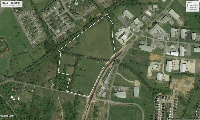
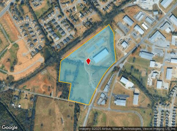
750 Aviation Lane Pvt Rd
Nashville-Davidson--Murfreesboro--Franklin, TN
Aero Business Park
127-001.01
DISTRICT: 03, COUNTY AREA: D00
Commercialacreage
Sumner
A
Tennessee
47165C0318G
1
2024
29.67 AC
2025
Rivergate/Hendersonville
020905
Nashville
42,000 SF
DEMOGRAPHICS near 750 Aviation Lane Pvt Rd
1 Mile
3 Mile
5 Mile
2024 Total Population
2,496
25,943
45,790
2029 Population
2,766
28,897
51,274
Pop Growth 2024-2029
+ 10.82%
+ 11.39%
+ 11.98%
Average Age
45
39
40
2024 Total Households
1,010
9,924
17,780
HH Growth 2024-2029
+ 11.09%
+ 11.61%
+ 12.21%
Median Household Inc
$58,529
$48,103
$58,400
Avg Household Size
2.40
2.50
2.50
2024 Avg HH Vehicles
2.00
2.00
2.00
Median Home Value
$352,247
$248,663
$305,981
Median Year Built
1992
1983
1993
Nearby Places
Map Layers
Map Styles
 Street
 Aerial
- Restaurants
- Banks
- Shops
- Fitness
- Groceries
PUBLIC TRANSPORTATION
AIRPORT
Nashville International
DRIVE
WALK
Distance
Nashville International
42 min
33.2 mi
Freight Ports
Port of Toledo
DRIVE
WALK
Distance
Port of Toledo
528 min
464.5 mi
SALE & LEASE HISTORY
LISTING DATE
SALE/LEASE

Mar 18, 2022
For Sale
Jun 30, 2021
For Sale
Aug 11, 2021
For Sale
Apr 22, 2020
For Sale
Nearby Properties
Address
Land Use
TOTAL SIZE
Lot Size
Zoning
Address
Land Use
TOTAL SIZE
Lot Size
Zoning
981,430 SF
512.54 AC
Address
Land Use
TOTAL SIZE
Lot Size
Zoning
38,900 SF
11.14 AC
Address
Land Use
TOTAL SIZE
Lot Size
Zoning
164,784 SF
99.88 AC
Address
Land Use
TOTAL SIZE
Lot Size
Zoning
85,320 SF
28.56 AC
IR
Address
Land Use
TOTAL SIZE
Lot Size
Zoning
52,475 SF
14.46 AC
Address
Land Use
TOTAL SIZE
Lot Size
Zoning
416,888 SF
42.88 AC
Address
Land Use
TOTAL SIZE
Lot Size
Zoning
10,320 SF
76.70 AC
IG
Address
Land Use
TOTAL SIZE
Lot Size
Zoning
10,656 SF
1.71 AC
R06
Address
Land Use
TOTAL SIZE
Lot Size
Zoning
7,424 SF
15.77 AC
Address
Land Use
TOTAL SIZE
Lot Size
Zoning
82,974 SF
11.19 AC
IR
Address
Land Use
TOTAL SIZE
Lot Size
Zoning
56,492 SF
4.72 AC
Address
Land Use
TOTAL SIZE
Lot Size
Zoning
426,312 SF
40 AC
IG
Address
Land Use
TOTAL SIZE
Lot Size
Zoning
9,568 SF
16.50 AC
Address
Land Use
TOTAL SIZE
Lot Size
Zoning
127,050 SF
Address
Land Use
TOTAL SIZE
Lot Size
Zoning
35,569 SF
6.99 AC
Address
Land Use
TOTAL SIZE
Lot Size
Zoning
20,000 SF
16.70 AC
Address
Land Use
TOTAL SIZE
Lot Size
Zoning
64,960 SF
15.11 AC
IG
Address
Land Use
TOTAL SIZE
Lot Size
Zoning
900 SF
51.03 AC
R1A
Address
Land Use
TOTAL SIZE
Lot Size
Zoning
370,211 SF
28.30 AC
Address
Land Use
TOTAL SIZE
Lot Size
Zoning
106,660 SF
18.74 AC
IG
Address
Land Use
TOTAL SIZE
Lot Size
Zoning
18,016 SF
17.90 AC
Address
Land Use
TOTAL SIZE
Lot Size
Zoning
99,294 SF
5.35 AC
Address
Land Use
TOTAL SIZE
Lot Size
Zoning
23,080 SF
2.07 AC
Address
Land Use
TOTAL SIZE
Lot Size
Zoning
142,992 SF
18.11 AC
Address
Land Use
TOTAL SIZE
Lot Size
Zoning
865 SF
0.77 AC
Address
Land Use
TOTAL SIZE
Lot Size
Zoning
14,016 SF
13.91 AC
IR
Address
Land Use
TOTAL SIZE
Lot Size
Zoning
65,933 SF
6.13 AC
Address
Land Use
TOTAL SIZE
Lot Size
Zoning
3,648 SF
25.70 AC
IR
Address
Land Use
TOTAL SIZE
Lot Size
Zoning
89,860 SF
7.72 AC
Address
Land Use
TOTAL SIZE
Lot Size
Zoning
64,000 SF
23.76 AC
IG
The World's #1 Commercial Real Estate Marketplace
Connect with us
© 2025 CoStar Group
The information above has been obtained from sources believed reliable. While we do not doubt its accuracy we have not verified it and make no guarantee, warranty or representation about it. It is your responsibility to independently confirm its accuracy and completeness. Any projections, opinions, assumptions, or estimates used are for example only and do not represent the current or future performance of the property. The value of this transaction to you depends on tax and other factors which should be evaluated by your tax, financial, and legal advisors. You and your advisors should conduct a careful, independent investigation of the property to determine to your satisfaction the suitability of the property for your needs.