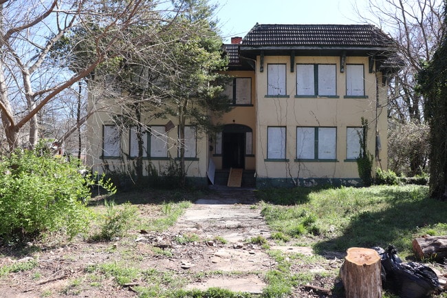
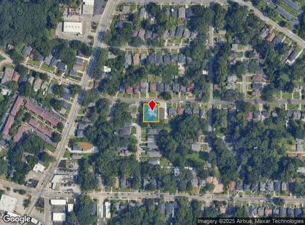
Property Record
750 Cascade Pl Sw, Atlanta, GA 30310
NEARBY LISTINGS FOR SALE OR LEASE
Property Detail
750 Cascade Pl Sw
Atlanta-Sandy Springs-Roswell, GA
Peoples Cmnty Dev Corp
14-0139-0005-145-3
KA APARTMENTS CB26 FOR 100% RENO COMPLETION
Apartment
Fulton
X
Georgia
13121C0356F
139
2024
0.26 AC
2025
West End
006000
Atlanta
8,244 SF
DEMOGRAPHICS near 750 Cascade Pl Sw
1 Mile
3 Mile
5 Mile
2024 Total Population
12,955
110,881
332,801
2029 Population
13,528
116,770
347,649
Pop Growth 2024-2029
+ 4.42%
+ 5.31%
+ 4.46%
Average Age
40
38
37
2024 Total Households
5,562
45,984
147,349
HH Growth 2024-2029
+ 4.44%
+ 5.52%
+ 4.72%
Median Household Inc
$48,479
$36,879
$60,028
Avg Household Size
2.30
2.20
2.00
2024 Avg HH Vehicles
1.00
1.00
1.00
Median Home Value
$342,659
$265,845
$312,372
Median Year Built
1949
1967
1986
Nearby Places
Map Layers
Map Styles
 Street
 Aerial
- Restaurants
- Banks
- Shops
- Fitness
- Groceries
PUBLIC TRANSPORTATION
COMMUTER RAIL
DRIVE
WALK
Distance
14 min
7.1 mi
AIRPORT
Hartsfield - Jackson Atlanta International
DRIVE
WALK
Distance
Hartsfield - Jackson Atlanta International
19 min
10.2 mi
SALE & LEASE HISTORY
LISTING DATE
SALE/LEASE

Sep 14, 2020
For Sale
Jul 25, 2018
For Sale
Apr 04, 2018
For Sale
Nearby Properties
Address
Land Use
TOTAL SIZE
Lot Size
Zoning
Address
Land Use
TOTAL SIZE
Lot Size
Zoning
19.94 AC
SPI1
Address
Land Use
TOTAL SIZE
Lot Size
Zoning
11.74 AC
I1
Address
Land Use
TOTAL SIZE
Lot Size
Zoning
9.80 AC
C5
Address
Land Use
TOTAL SIZE
Lot Size
Zoning
10.27 AC
C5
Address
Land Use
TOTAL SIZE
Lot Size
Zoning
61.57 AC
C5
Address
Land Use
TOTAL SIZE
Lot Size
Zoning
1.55 AC
SPI1
Address
Land Use
TOTAL SIZE
Lot Size
Zoning
7 AC
C3
Address
Land Use
TOTAL SIZE
Lot Size
Zoning
3.62 AC
SPI1
Address
Land Use
TOTAL SIZE
Lot Size
Zoning
631,858 SF
1.33 AC
C5C
Address
Land Use
TOTAL SIZE
Lot Size
Zoning
34 AC
OI
Address
Land Use
TOTAL SIZE
Lot Size
Zoning
498,515 SF
3.41 AC
C1
Address
Land Use
TOTAL SIZE
Lot Size
Zoning
979,670 SF
0.82 AC
SPI1
Address
Land Use
TOTAL SIZE
Lot Size
Zoning
903,364 SF
1.08 AC
SPI1
Address
Land Use
TOTAL SIZE
Lot Size
Zoning
1,146,402 SF
4.74 AC
SPI1
Address
Land Use
TOTAL SIZE
Lot Size
Zoning
469,344 SF
3.62 AC
C3
Address
Land Use
TOTAL SIZE
Lot Size
Zoning
9.85 AC
SPI1
Address
Land Use
TOTAL SIZE
Lot Size
Zoning
357,153 SF
0.60 AC
SPI1
Address
Land Use
TOTAL SIZE
Lot Size
Zoning
0.08 AC
SPI1
Address
Land Use
TOTAL SIZE
Lot Size
Zoning
541,508 SF
110.88 AC
I1
Address
Land Use
TOTAL SIZE
Lot Size
Zoning
283,235 SF
5 AC
RG4
Address
Land Use
TOTAL SIZE
Lot Size
Zoning
3.65 AC
SPI1
Address
Land Use
TOTAL SIZE
Lot Size
Zoning
5.34 AC
SPI1
Address
Land Use
TOTAL SIZE
Lot Size
Zoning
857,294 SF
101.10 AC
I1
Address
Land Use
TOTAL SIZE
Lot Size
Zoning
293,935 SF
8.47 AC
I2
Address
Land Use
TOTAL SIZE
Lot Size
Zoning
0.40 AC
SPI1
Address
Land Use
TOTAL SIZE
Lot Size
Zoning
319,114 SF
1.60 AC
C5
Address
Land Use
TOTAL SIZE
Lot Size
Zoning
1.05 AC
SPI1
Address
Land Use
TOTAL SIZE
Lot Size
Zoning
3,411,710 SF
25.97 AC
RG3
Address
Land Use
TOTAL SIZE
Lot Size
Zoning
0.49 AC
SPI1
Address
Land Use
TOTAL SIZE
Lot Size
Zoning
569,908 SF
2.22 AC
I1
The World's #1 Commercial Real Estate Marketplace
Connect with us
© 2025 CoStar Group
The information above has been obtained from sources believed reliable. While we do not doubt its accuracy we have not verified it and make no guarantee, warranty or representation about it. It is your responsibility to independently confirm its accuracy and completeness. Any projections, opinions, assumptions, or estimates used are for example only and do not represent the current or future performance of the property. The value of this transaction to you depends on tax and other factors which should be evaluated by your tax, financial, and legal advisors. You and your advisors should conduct a careful, independent investigation of the property to determine to your satisfaction the suitability of the property for your needs.