Property Record
750 Casserly Rd, Watsonville, CA 95076


NEARBY LISTINGS FOR SALE OR LEASE
-
-
View all Watsonville listings for sale on LoopNet.com
Property Detail
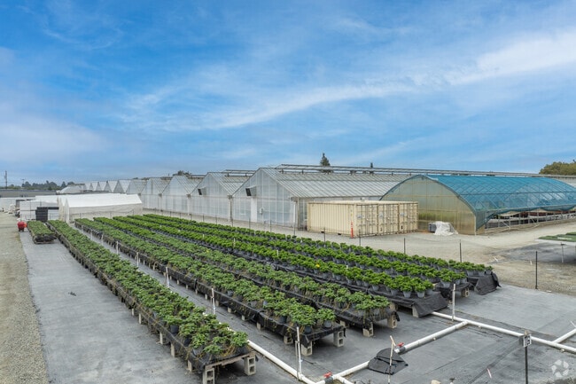
750 Casserly Rd
109-241-11-000
Rancho Salsipuedes
Horticulturegrowinghousesagricultural
Santa Cruz
X
California
06087C0382E
18.68 AC
2024
Outlying Santa Cruz Cnty
2025
Santa Cruz/Watsonville
122401
Santa Cruz-Watsonville, CA
5,961 SF
DEMOGRAPHICS near 750 Casserly Rd
1 Mile
3 Mile
5 Mile
2024 Total Population
1,860
14,780
69,292
2029 Population
1,795
14,192
66,954
Pop Growth 2024-2029
(3.49%)
(3.98%)
(3.37%)
Average Age
38
38
36
2024 Total Households
442
4,004
18,872
HH Growth 2024-2029
(4.30%)
(4.57%)
(3.83%)
Median Household Inc
$94,914
$91,418
$79,162
Avg Household Size
3.70
3.40
3.50
2024 Avg HH Vehicles
3.00
3.00
2.00
Median Home Value
$734,375
$706,575
$686,472
Median Year Built
1973
1971
1973
Nearby Places
Map Layers
Map Styles
 Street
 Aerial
- Restaurants
- Banks
- Shops
- Fitness
- Groceries
PUBLIC TRANSPORTATION
AIRPORT
Monterey Regional
DRIVE
WALK
Distance
Monterey Regional
44 min
32.5 mi
Norman Y Mineta San Jose International
DRIVE
WALK
Distance
Norman Y Mineta San Jose International
68 min
49.7 mi
Freight Ports
Port of Redwood City
DRIVE
WALK
Distance
Port of Redwood City
87 min
65.5 mi
Nearby Properties
Address
Land Use
TOTAL SIZE
Lot Size
Zoning
Address
Land Use
TOTAL SIZE
Lot Size
Zoning
3,767 SF
6.90 AC
RM-2-R
Address
Land Use
TOTAL SIZE
Lot Size
Zoning
60,392 SF
4.07 AC
RM-4
Address
Land Use
TOTAL SIZE
Lot Size
Zoning
5,963 SF
7.89 AC
Address
Land Use
TOTAL SIZE
Lot Size
Zoning
23,677 SF
67.25 AC
PF
Address
Land Use
TOTAL SIZE
Lot Size
Zoning
4.59 AC
CA
Address
Land Use
TOTAL SIZE
Lot Size
Zoning
41,700 SF
3 AC
PA
Address
Land Use
TOTAL SIZE
Lot Size
Zoning
14.98 AC
PF
Address
Land Use
TOTAL SIZE
Lot Size
Zoning
54,327 SF
1.25 AC
RM4GH
Address
Land Use
TOTAL SIZE
Lot Size
Zoning
27.77 AC
PR
Address
Land Use
TOTAL SIZE
Lot Size
Zoning
56,387 SF
4.57 AC
RM3
Address
Land Use
TOTAL SIZE
Lot Size
Zoning
1,898 SF
51.55 AC
CA
Address
Land Use
TOTAL SIZE
Lot Size
Zoning
Address
Land Use
TOTAL SIZE
Lot Size
Zoning
13.61 AC
CA
Address
Land Use
TOTAL SIZE
Lot Size
Zoning
79,554 SF
3.09 AC
Address
Land Use
TOTAL SIZE
Lot Size
Zoning
32.82 AC
CA
Address
Land Use
TOTAL SIZE
Lot Size
Zoning
29,269 SF
3.35 AC
RM-4-GH
Address
Land Use
TOTAL SIZE
Lot Size
Zoning
4,800 SF
13.80 AC
CA
Address
Land Use
TOTAL SIZE
Lot Size
Zoning
9,407 SF
40.22 AC
SU
Address
Land Use
TOTAL SIZE
Lot Size
Zoning
9,814 SF
1.47 AC
CA
Address
Land Use
TOTAL SIZE
Lot Size
Zoning
8,571 SF
54.67 AC
CA-P
Address
Land Use
TOTAL SIZE
Lot Size
Zoning
10,163 SF
308.15 AC
TP
Address
Land Use
TOTAL SIZE
Lot Size
Zoning
34.15 AC
CA
Address
Land Use
TOTAL SIZE
Lot Size
Zoning
3,916 SF
131.12 AC
CA
Address
Land Use
TOTAL SIZE
Lot Size
Zoning
8,840 SF
0.54 AC
RM-4
Address
Land Use
TOTAL SIZE
Lot Size
Zoning
16.54 AC
CA
Address
Land Use
TOTAL SIZE
Lot Size
Zoning
18,727 SF
0.72 AC
Address
Land Use
TOTAL SIZE
Lot Size
Zoning
39,306 SF
77.89 AC
CA-P
Address
Land Use
TOTAL SIZE
Lot Size
Zoning
576 SF
71.71 AC
CA
The World's #1 Commercial Real Estate Marketplace
Connect with us
© 2025 CoStar Group
The information above has been obtained from sources believed reliable. While we do not doubt its accuracy we have not verified it and make no guarantee, warranty or representation about it. It is your responsibility to independently confirm its accuracy and completeness. Any projections, opinions, assumptions, or estimates used are for example only and do not represent the current or future performance of the property. The value of this transaction to you depends on tax and other factors which should be evaluated by your tax, financial, and legal advisors. You and your advisors should conduct a careful, independent investigation of the property to determine to your satisfaction the suitability of the property for your needs.