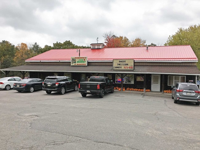
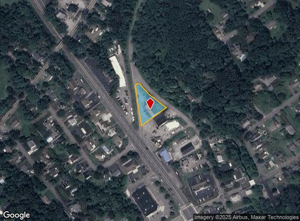
Property Record
Demunds Rd, Dallas, PA 18612
NEARBY LISTINGS FOR SALE OR LEASE
Property Detail
Demunds Rd
Scranton--Wilkes-Barre, PA
10-1136-2-D2-2 LOWER DEMUNDS RD
10-E8S4-004-16B-000
Luzerne
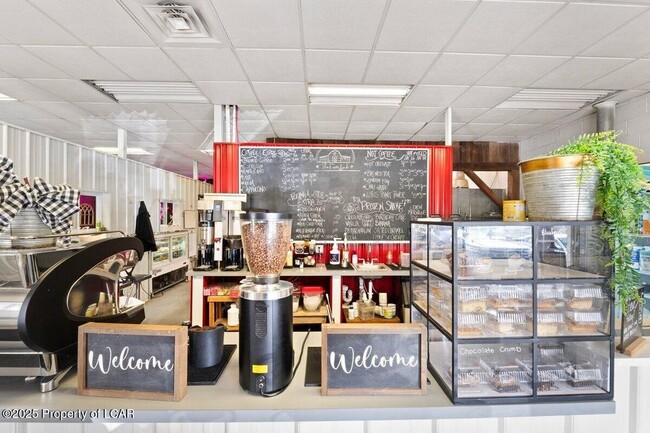
Storebuilding
Pennsylvania
X
16b
42079C0204E
0.91 AC
2025
I-81 Corridor
2025
Philadelphia
211204
DEMOGRAPHICS near Demunds Rd
1 Mile
3 Mile
5 Mile
2024 Total Population
4,840
17,937
55,461
2029 Population
4,847
17,861
55,299
Pop Growth 2024-2029
+ 0.14%
(0.42%)
(0.29%)
Average Age
44
43
43
2024 Total Households
2,033
7,112
23,163
HH Growth 2024-2029
+ 0.10%
(0.48%)
(0.35%)
Median Household Inc
$83,206
$93,294
$69,574
Avg Household Size
2.30
2.30
2.20
2024 Avg HH Vehicles
2.00
2.00
2.00
Median Home Value
$186,247
$235,956
$170,871
Median Year Built
1965
1973
1959
Nearby Places
Map Layers
Map Styles
 Street
 Aerial
- Restaurants
- Banks
- Shops
- Fitness
- Groceries
PUBLIC TRANSPORTATION
AIRPORT
Wilkes-Barre/Scranton International
DRIVE
WALK
Distance
Wilkes-Barre/Scranton International
29 min
17.6 mi
SALE & LEASE HISTORY
LISTING DATE
SALE/LEASE

Nov 05, 2019
For Sale
Mar 14, 2023
For Sale
Nearby Properties
Address
Land Use
TOTAL SIZE
Lot Size
Zoning
Address
Land Use
TOTAL SIZE
Lot Size
Zoning
100.57 AC
Address
Land Use
TOTAL SIZE
Lot Size
Zoning
Address
Land Use
TOTAL SIZE
Lot Size
Zoning
37.44 AC
Address
Land Use
TOTAL SIZE
Lot Size
Zoning
15.71 AC
Address
Land Use
TOTAL SIZE
Lot Size
Zoning
13.04 AC
Address
Land Use
TOTAL SIZE
Lot Size
Zoning
6.77 AC
Address
Land Use
TOTAL SIZE
Lot Size
Zoning
13.02 AC
Address
Land Use
TOTAL SIZE
Lot Size
Zoning
4.73 AC
Address
Land Use
TOTAL SIZE
Lot Size
Zoning
40.48 AC
Address
Land Use
TOTAL SIZE
Lot Size
Zoning
15.56 AC
Address
Land Use
TOTAL SIZE
Lot Size
Zoning
338.92 AC
Address
Land Use
TOTAL SIZE
Lot Size
Zoning
16.33 AC
Address
Land Use
TOTAL SIZE
Lot Size
Zoning
6.92 AC
Address
Land Use
TOTAL SIZE
Lot Size
Zoning
6.90 AC
Address
Land Use
TOTAL SIZE
Lot Size
Zoning
1.35 AC
Address
Land Use
TOTAL SIZE
Lot Size
Zoning
Address
Land Use
TOTAL SIZE
Lot Size
Zoning
Address
Land Use
TOTAL SIZE
Lot Size
Zoning
4.22 AC
Address
Land Use
TOTAL SIZE
Lot Size
Zoning
7 AC
Address
Land Use
TOTAL SIZE
Lot Size
Zoning
Address
Land Use
TOTAL SIZE
Lot Size
Zoning
9.13 AC
Address
Land Use
TOTAL SIZE
Lot Size
Zoning
4.40 AC
Address
Land Use
TOTAL SIZE
Lot Size
Zoning
Address
Land Use
TOTAL SIZE
Lot Size
Zoning
3.25 AC
Address
Land Use
TOTAL SIZE
Lot Size
Zoning
191.45 AC
Address
Land Use
TOTAL SIZE
Lot Size
Zoning
24.42 AC
Address
Land Use
TOTAL SIZE
Lot Size
Zoning
Address
Land Use
TOTAL SIZE
Lot Size
Zoning
2.50 AC
Address
Land Use
TOTAL SIZE
Lot Size
Zoning
2.97 AC
Address
Land Use
TOTAL SIZE
Lot Size
Zoning
5.05 AC
The World's #1 Commercial Real Estate Marketplace
Connect with us
© 2026 CoStar Group
The information above has been obtained from sources believed reliable. While we do not doubt its accuracy we have not verified it and make no guarantee, warranty or representation about it. It is your responsibility to independently confirm its accuracy and completeness. Any projections, opinions, assumptions, or estimates used are for example only and do not represent the current or future performance of the property. The value of this transaction to you depends on tax and other factors which should be evaluated by your tax, financial, and legal advisors. You and your advisors should conduct a careful, independent investigation of the property to determine to your satisfaction the suitability of the property for your needs.