Property Record
750 Miller Dr Se, Leesburg, VA 20175


NEARBY LISTINGS FOR SALE OR LEASE
-
-
View all Leesburg listings for sale on LoopNet.com
Property Detail
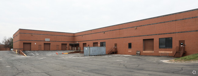
750 Miller Dr Se
191-35-3864
Richlynn Development Div
Officebuilding
RICHLYNN DEVELOPMENT DIV PARCEL B-B 201809070052667/8P
X
Loudoun
51107C0235E
Virginia
0
17.95 AC
2025
Leesburg
610604
Washington, DC
261,445 SF
Washington-Arlington-Alexandria, DC-VA-MD-WV
DEMOGRAPHICS near 750 Miller Dr Se
1 Mile
3 Mile
5 Mile
2024 Total Population
5,813
56,840
121,460
2029 Population
6,232
61,312
130,770
Pop Growth 2024-2029
+ 7.21%
+ 7.87%
+ 7.67%
Average Age
37
37
38
2024 Total Households
1,900
18,707
40,451
HH Growth 2024-2029
+ 7.37%
+ 7.95%
+ 7.81%
Median Household Inc
$178,103
$130,369
$154,341
Avg Household Size
3.00
3.00
2.90
2024 Avg HH Vehicles
2.00
2.00
2.00
Median Home Value
$654,653
$624,350
$677,749
Median Year Built
2001
1995
1998
Nearby Places
Map Layers
Map Styles
 Street
 Aerial
- Restaurants
- Banks
- Shops
- Fitness
- Groceries
PUBLIC TRANSPORTATION
AIRPORT
Washington Dulles International
DRIVE
WALK
Distance
Washington Dulles International
38 min
19.2 mi
Ronald Reagan Washington Ntl
DRIVE
WALK
Distance
Ronald Reagan Washington Ntl
52 min
41.3 mi
Nearby Properties
Address
Land Use
TOTAL SIZE
Lot Size
Zoning
Address
Land Use
TOTAL SIZE
Lot Size
Zoning
793,474 SF
311.38 AC
PDIP
Address
Land Use
TOTAL SIZE
Lot Size
Zoning
250,459 SF
OP
Address
Land Use
TOTAL SIZE
Lot Size
Zoning
356,841 SF
119.07 AC
PDGI
Address
Land Use
TOTAL SIZE
Lot Size
Zoning
413,297 SF
21.77 AC
LB:MC
Address
Land Use
TOTAL SIZE
Lot Size
Zoning
485,476 SF
54.14 AC
LB:B3
Address
Land Use
TOTAL SIZE
Lot Size
Zoning
108.01 AC
PDOP
Address
Land Use
TOTAL SIZE
Lot Size
Zoning
553,617 SF
592.60 AC
PDSA
Address
Land Use
TOTAL SIZE
Lot Size
Zoning
340,152 SF
119.26 AC
TR10
Address
Land Use
TOTAL SIZE
Lot Size
Zoning
420,787 SF
LB:B4
Address
Land Use
TOTAL SIZE
Lot Size
Zoning
37.61 AC
IP
Address
Land Use
TOTAL SIZE
Lot Size
Zoning
300,570 SF
OP
Address
Land Use
TOTAL SIZE
Lot Size
Zoning
248,513 SF
15.77 AC
LB:R22
Address
Land Use
TOTAL SIZE
Lot Size
Zoning
323,043 SF
27.90 AC
LB:B3
Address
Land Use
TOTAL SIZE
Lot Size
Zoning
228,886 SF
29.43 AC
LB:B3
Address
Land Use
TOTAL SIZE
Lot Size
Zoning
198,300 SF
36.09 AC
PDIP
Address
Land Use
TOTAL SIZE
Lot Size
Zoning
413,099 SF
10.12 AC
PDIP
Address
Land Use
TOTAL SIZE
Lot Size
Zoning
388,150 SF
PDIP
Address
Land Use
TOTAL SIZE
Lot Size
Zoning
245,886 SF
52.32 AC
LB:RE
Address
Land Use
TOTAL SIZE
Lot Size
Zoning
158,560 SF
2.44 AC
LB:GC
Address
Land Use
TOTAL SIZE
Lot Size
Zoning
294,934 SF
7.11 AC
PDIP
Address
Land Use
TOTAL SIZE
Lot Size
Zoning
258,867 SF
12.57 AC
LB:R22
Address
Land Use
TOTAL SIZE
Lot Size
Zoning
131,283 SF
27.84 AC
LB:B3
Address
Land Use
TOTAL SIZE
Lot Size
Zoning
148,448 SF
9.71 AC
LB:PEC
Address
Land Use
TOTAL SIZE
Lot Size
Zoning
190,454 SF
31.50 AC
LB:R4
Address
Land Use
TOTAL SIZE
Lot Size
Zoning
83,169 SF
138.05 AC
LB:R1
Address
Land Use
TOTAL SIZE
Lot Size
Zoning
196,665 SF
18.96 AC
LB:PRN
Address
Land Use
TOTAL SIZE
Lot Size
Zoning
156,958 SF
17.63 AC
LB:PRC
Address
Land Use
TOTAL SIZE
Lot Size
Zoning
31.69 AC
GI
Address
Land Use
TOTAL SIZE
Lot Size
Zoning
18.85 AC
PDH4
The World's #1 Commercial Real Estate Marketplace
Connect with us
© 2025 CoStar Group
The information above has been obtained from sources believed reliable. While we do not doubt its accuracy we have not verified it and make no guarantee, warranty or representation about it. It is your responsibility to independently confirm its accuracy and completeness. Any projections, opinions, assumptions, or estimates used are for example only and do not represent the current or future performance of the property. The value of this transaction to you depends on tax and other factors which should be evaluated by your tax, financial, and legal advisors. You and your advisors should conduct a careful, independent investigation of the property to determine to your satisfaction the suitability of the property for your needs.