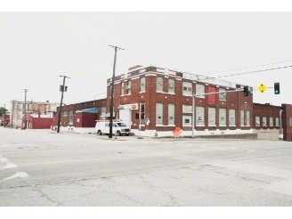
Property Record
750 N Main St, Decatur, IL 62521


NEARBY LISTINGS FOR SALE OR LEASE
Property Detail
750 N Main St
Decatur, IL
Durfees Add
04-12-10-484-001
DURFEES ADD N/K/A HB DURFEES ~ADDITION LOTS 2 & 3 BLK 1 ~TIF ~760 N MAIN ST 177X150
Warehouse
Macon
X
Illinois
17115C0305E
2-3
0
0.61 AC
2024
Springfield/Decatur
001200
Other Market Areas
DEMOGRAPHICS near 750 N Main St
1 Mile
3 Mile
5 Mile
2024 Total Population
12,351
53,017
75,988
2029 Population
12,460
52,092
74,157
Pop Growth 2024-2029
+ 0.88%
(1.74%)
(2.41%)
Average Age
36
40
41
2024 Total Households
5,119
23,077
33,214
HH Growth 2024-2029
+ 1.00%
(1.83%)
(2.50%)
Median Household Inc
$23,392
$38,838
$43,326
Avg Household Size
2.10
2.10
2.10
2024 Avg HH Vehicles
1.00
1.00
2.00
Median Home Value
$61,890
$76,255
$93,074
Median Year Built
1948
1956
1960
Nearby Places
Map Layers
Map Styles
 Street
 Aerial
- Restaurants
- Banks
- Shops
- Fitness
- Groceries
SALE & LEASE HISTORY
LISTING DATE
SALE/LEASE

Sep 24, 2016
For Sale
Nearby Properties
Address
Land Use
TOTAL SIZE
Lot Size
Zoning
Address
Land Use
TOTAL SIZE
Lot Size
Zoning
68.23 AC
MUNICIPAL
Address
Land Use
TOTAL SIZE
Lot Size
Zoning
1.03 AC
MUNICIPAL
Address
Land Use
TOTAL SIZE
Lot Size
Zoning
1.40 AC
MUNICIPAL
Address
Land Use
TOTAL SIZE
Lot Size
Zoning
6.60 AC
MUNICIPAL
Address
Land Use
TOTAL SIZE
Lot Size
Zoning
Address
Land Use
TOTAL SIZE
Lot Size
Zoning
12.24 AC
MUNICIPAL
Address
Land Use
TOTAL SIZE
Lot Size
Zoning
6.68 AC
MUNICIPAL
Address
Land Use
TOTAL SIZE
Lot Size
Zoning
18.50 AC
MUNICIPAL
Address
Land Use
TOTAL SIZE
Lot Size
Zoning
6.89 AC
MUNICIPAL
Address
Land Use
TOTAL SIZE
Lot Size
Zoning
19.95 AC
MUNICIPAL
Address
Land Use
TOTAL SIZE
Lot Size
Zoning
7.82 AC
MUNICIPAL
Address
Land Use
TOTAL SIZE
Lot Size
Zoning
3.35 AC
MUNICIPAL
Address
Land Use
TOTAL SIZE
Lot Size
Zoning
25.59 AC
MUNICIPAL
Address
Land Use
TOTAL SIZE
Lot Size
Zoning
1.10 AC
MUNICIPAL
Address
Land Use
TOTAL SIZE
Lot Size
Zoning
78.13 AC
MUNICIPAL
Address
Land Use
TOTAL SIZE
Lot Size
Zoning
6.35 AC
MUNICIPAL
Address
Land Use
TOTAL SIZE
Lot Size
Zoning
3.93 AC
MUNICIPAL
Address
Land Use
TOTAL SIZE
Lot Size
Zoning
14.33 AC
MUNICIPAL
Address
Land Use
TOTAL SIZE
Lot Size
Zoning
54.49 AC
MUNICIPAL
Address
Land Use
TOTAL SIZE
Lot Size
Zoning
4.30 AC
MUNICIPAL
Address
Land Use
TOTAL SIZE
Lot Size
Zoning
0.97 AC
MUNICIPAL
Address
Land Use
TOTAL SIZE
Lot Size
Zoning
3.50 AC
MUNICIPAL
Address
Land Use
TOTAL SIZE
Lot Size
Zoning
1.73 AC
MUNICIPAL
Address
Land Use
TOTAL SIZE
Lot Size
Zoning
14.76 AC
MUNICIPAL
Address
Land Use
TOTAL SIZE
Lot Size
Zoning
3.86 AC
MUNICIPAL
Address
Land Use
TOTAL SIZE
Lot Size
Zoning
14.80 AC
MUNICIPAL
Address
Land Use
TOTAL SIZE
Lot Size
Zoning
Address
Land Use
TOTAL SIZE
Lot Size
Zoning
9.11 AC
MUNICIPAL
Address
Land Use
TOTAL SIZE
Lot Size
Zoning
35.07 AC
MUNICIPAL
The World's #1 Commercial Real Estate Marketplace
Connect with us
© 2026 CoStar Group
The information above has been obtained from sources believed reliable. While we do not doubt its accuracy we have not verified it and make no guarantee, warranty or representation about it. It is your responsibility to independently confirm its accuracy and completeness. Any projections, opinions, assumptions, or estimates used are for example only and do not represent the current or future performance of the property. The value of this transaction to you depends on tax and other factors which should be evaluated by your tax, financial, and legal advisors. You and your advisors should conduct a careful, independent investigation of the property to determine to your satisfaction the suitability of the property for your needs.