Property Record
750 Queen St, Southington, CT 06489
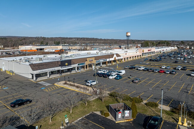
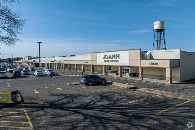
Property Detail
750 Queen St
SOUT-000181-000000-000003-000001
HARTFORD
Regionalshoppingcenterormallwithanchorstore
Connecticut
B
2
B and X Area of moderate flood hazard, usually the area between the limits of the 100-year and 500-year floods.
13.66 AC
2025
Southington
2025
Hartford
430604
Hartford-West Hartford-East Hartford, CT
149,912 SF
NEARBY LISTINGS FOR SALE OR LEASE
DEMOGRAPHICS near 750 Queen St
1 mile
3 mile
5 mile
2025 Total Population
3,369
44,176
131,779
2030 Population
3,499
45,218
134,555
Pop Growth 2025-2030
+ 3.86%
+ 2.36%
+ 2.11%
Average Age
46
43
42
2025 Total Households
1,469
19,225
54,653
HH Growth 2025-2030
+ 3.95%
+ 2.36%
+ 2.14%
Median Household Inc
$111,995
$90,630
$87,227
Avg Household Size
2.30
2.30
2.30
2025 Avg HH Vehicles
2.00
2.00
2.00
Median Home Value
$360,515
$312,460
$302,246
Median Year Built
1978
1973
1965
Nearby Places
Map Layers
Map Styles
 Street
 Aerial
Layers
 Traffic
 Biking
Places
Listings with unknown addresses are not visible on the map
- Restaurants
- Banks
- Shops
- Fitness
- Groceries
PUBLIC TRANSPORTATION
COMMUTER RAIL
Berlin (Hartford Line - CONN DOT)
Drive
Walk
Distance
Berlin (Hartford Line - CONN DOT)
14 min
8.7 mi
Berlin Amtrak (Amtrak Hartford Line - Amtrak, Northeast Regional - Amtrak, Valley Flyer - Amtrak)
Drive
Walk
Distance
Berlin Amtrak (Amtrak Hartford Line - Amtrak, Northeast Regional - Amtrak, Valley Flyer - Amtrak)
14 min
8.7 mi
AIRPORT
Tweed/New Haven
Drive
Walk
Distance
Tweed/New Haven
42 min
29.0 mi
Bradley International
Drive
Walk
Distance
Bradley International
53 min
29.9 mi
Freight Ports
Port of New Haven
Drive
Walk
Distance
Port of New Haven
37 min
26.7 mi
SALE & LEASE HISTORY
LISTING DATE
SALE/LEASE

Sep 04, 2019
For Lease
Mar 05, 2018
For Lease
Nearby Properties
Address
Land Use
TOTAL SIZE
Lot Size
Zoning
Address
Land Use
TOTAL SIZE
Lot Size
Zoning
77,001 SF
54.59 AC
IP-1
Address
Land Use
TOTAL SIZE
Lot Size
Zoning
100,304 SF
28.80 AC
IP-1
Address
Land Use
TOTAL SIZE
Lot Size
Zoning
58,473 SF
18.20 AC
IP-1
Address
Land Use
TOTAL SIZE
Lot Size
Zoning
145,719 SF
17.90 AC
R-15
Address
Land Use
TOTAL SIZE
Lot Size
Zoning
395,492 SF
54.09 AC
R-20/2
Address
Land Use
TOTAL SIZE
Lot Size
Zoning
114,375 SF
12.72 AC
IP-1
Address
Land Use
TOTAL SIZE
Lot Size
Zoning
330,400 SF
36.90 AC
IP-1
Address
Land Use
TOTAL SIZE
Lot Size
Zoning
28.47 AC
R-10
Address
Land Use
TOTAL SIZE
Lot Size
Zoning
106,970 SF
7.92 AC
R-12
Address
Land Use
TOTAL SIZE
Lot Size
Zoning
128,599 SF
14.75 AC
R-20/2
Address
Land Use
TOTAL SIZE
Lot Size
Zoning
502,440 SF
27.87 AC
I-2
Address
Land Use
TOTAL SIZE
Lot Size
Zoning
17.62 AC
B
Address
Land Use
TOTAL SIZE
Lot Size
Zoning
3,084 SF
14.90 AC
BG
Address
Land Use
TOTAL SIZE
Lot Size
Zoning
133,720 SF
7.34 AC
IP-1
Address
Land Use
TOTAL SIZE
Lot Size
Zoning
130,252 SF
14.82 AC
B
Address
Land Use
TOTAL SIZE
Lot Size
Zoning
137,510 SF
12.95 AC
B
Address
Land Use
TOTAL SIZE
Lot Size
Zoning
16.04 AC
B
Address
Land Use
TOTAL SIZE
Lot Size
Zoning
1,250 SF
14.90 AC
I
Address
Land Use
TOTAL SIZE
Lot Size
Zoning
150,972 SF
9.99 AC
I-1
Address
Land Use
TOTAL SIZE
Lot Size
Zoning
98,463 SF
5.01 AC
I-1
Address
Land Use
TOTAL SIZE
Lot Size
Zoning
109,212 SF
20.15 AC
B
Address
Land Use
TOTAL SIZE
Lot Size
Zoning
121,648 SF
6.96 AC
I-1
Address
Land Use
TOTAL SIZE
Lot Size
Zoning
134,876 SF
19.44 AC
R-12
Address
Land Use
TOTAL SIZE
Lot Size
Zoning
95,940 SF
12 AC
B
Address
Land Use
TOTAL SIZE
Lot Size
Zoning
12.28 AC
R-20/2
Address
Land Use
TOTAL SIZE
Lot Size
Zoning
9.07 AC
B
Address
Land Use
TOTAL SIZE
Lot Size
Zoning
40 AC
I-2
Address
Land Use
TOTAL SIZE
Lot Size
Zoning
101,495 SF
9.74 AC
B
Address
Land Use
TOTAL SIZE
Lot Size
Zoning
67,503 SF
2.53 AC
B
The World's #1 Commercial Real Estate Marketplace
Connect with us
© 2026 CoStar Group
The information above has been obtained from sources believed reliable. While we do not doubt its accuracy we have not verified it and make no guarantee, warranty or representation about it. It is your responsibility to independently confirm its accuracy and completeness. Any projections, opinions, assumptions, or estimates used are for example only and do not represent the current or future performance of the property. The value of this transaction to you depends on tax and other factors which should be evaluated by your tax, financial, and legal advisors. You and your advisors should conduct a careful, independent investigation of the property to determine to your satisfaction the suitability of the property for your needs.