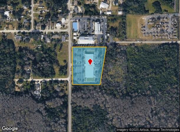
Property Record
750 S 5Th St, Immokalee, FL 34142
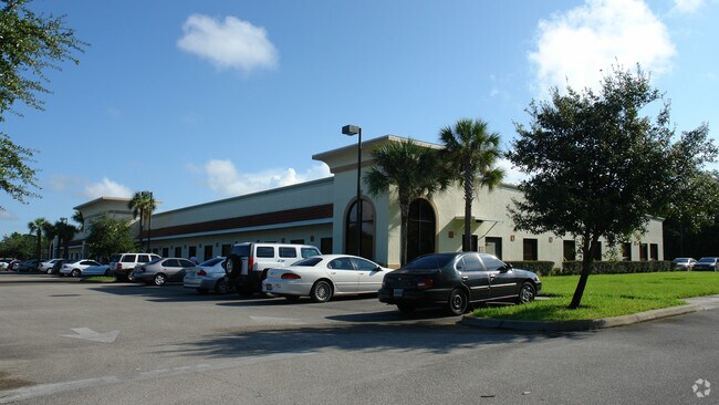
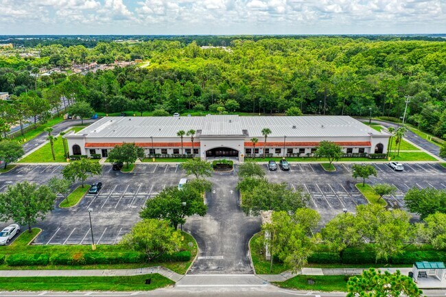
This Property Is For Sale
NEARBY LISTINGS FOR SALE OR LEASE
-
-
View all Immokalee listings for sale on LoopNet.com
Property Detail
750 S 5Th St
00136440709
Acreage Header
Orphanage
9 47 29 COMM AT SW CNR OF NW 1/4 OF SE1/4 OF NE1/4, S89DEG 4238E 20FT, N00DEG 2600E 145FT TO POB, N00DEG 2500E 456.50FT, S89DEG 4915E 402FT , S09DEG 4421W 456.94FT, N 89DEG 0732W 326.50FT TO POB
AH
Collier
12021C0145H
Florida
0
3.83 AC
2025
Outlying Collier County
011204
Southwest Florida
28,582 SF
Naples-Immokalee-Marco Island, FL
DEMOGRAPHICS near 750 S 5Th St
1 Mile
3 Mile
5 Mile
2024 Total Population
4,477
16,324
21,447
2029 Population
4,669
17,491
23,278
Pop Growth 2024-2029
+ 4.29%
+ 7.15%
+ 8.54%
Average Age
33
31
31
2024 Total Households
1,208
4,266
5,508
HH Growth 2024-2029
+ 2.81%
+ 6.19%
+ 7.64%
Median Household Inc
$33,608
$39,465
$42,839
Avg Household Size
3.20
3.40
3.50
2024 Avg HH Vehicles
1.00
2.00
2.00
Median Home Value
$176,548
$161,482
$184,278
Median Year Built
1989
1990
1993
Nearby Places
Map Layers
Map Styles
 Street
 Aerial
- Restaurants
- Banks
- Shops
- Fitness
- Groceries
PUBLIC TRANSPORTATION
AIRPORT
Southwest Florida International
DRIVE
WALK
Distance
Southwest Florida International
44 min
29.6 mi
Nearby Properties
Address
Land Use
TOTAL SIZE
Lot Size
Zoning
Address
Land Use
TOTAL SIZE
Lot Size
Zoning
217,887 SF
564.45 AC
A-MHO
Address
Land Use
TOTAL SIZE
Lot Size
Zoning
243,268 SF
43.41 AC
RSF-3
Address
Land Use
TOTAL SIZE
Lot Size
Zoning
467,375 SF
79.87 AC
RMF-6
Address
Land Use
TOTAL SIZE
Lot Size
Zoning
150,228 SF
172.69 AC
I
Address
Land Use
TOTAL SIZE
Lot Size
Zoning
139,063 SF
22.83 AC
RSF-3
Address
Land Use
TOTAL SIZE
Lot Size
Zoning
182,696 SF
12.78 AC
MPUD
Address
Land Use
TOTAL SIZE
Lot Size
Zoning
59,982 SF
23.58 AC
A-MHO
Address
Land Use
TOTAL SIZE
Lot Size
Zoning
39,880 SF
6.52 AC
RMF-6
Address
Land Use
TOTAL SIZE
Lot Size
Zoning
152,819 SF
17.50 AC
I-FMOSD
Address
Land Use
TOTAL SIZE
Lot Size
Zoning
336.06 AC
AOPUD
Address
Land Use
TOTAL SIZE
Lot Size
Zoning
39,087 SF
3.47 AC
C-4-MSOSD
Address
Land Use
TOTAL SIZE
Lot Size
Zoning
80,165 SF
20 AC
A-MHO
Address
Land Use
TOTAL SIZE
Lot Size
Zoning
74,473 SF
10.29 AC
VR
Address
Land Use
TOTAL SIZE
Lot Size
Zoning
38,837 SF
9.41 AC
PUD
Address
Land Use
TOTAL SIZE
Lot Size
Zoning
40,862 SF
6.57 AC
PUD
Address
Land Use
TOTAL SIZE
Lot Size
Zoning
90,082 SF
9.37 AC
MPUD
Address
Land Use
TOTAL SIZE
Lot Size
Zoning
25,308 SF
5.96 AC
PUD
Address
Land Use
TOTAL SIZE
Lot Size
Zoning
33,530 SF
3.83 AC
PUD
Address
Land Use
TOTAL SIZE
Lot Size
Zoning
45,799 SF
8.70 AC
RMF-6
Address
Land Use
TOTAL SIZE
Lot Size
Zoning
59,859 SF
18.04 AC
RMF-6
Address
Land Use
TOTAL SIZE
Lot Size
Zoning
20,484 SF
3.03 AC
C-5-AOSD
Address
Land Use
TOTAL SIZE
Lot Size
Zoning
4,719 SF
2.95 AC
C-4-MSOSD
Address
Land Use
TOTAL SIZE
Lot Size
Zoning
78,445 SF
6.40 AC
RMF-16
Address
Land Use
TOTAL SIZE
Lot Size
Zoning
20,566 SF
7.42 AC
C-4-MSOSD
Address
Land Use
TOTAL SIZE
Lot Size
Zoning
48,224 SF
4 AC
I
Address
Land Use
TOTAL SIZE
Lot Size
Zoning
27,951 SF
7.95 AC
RSF3
Address
Land Use
TOTAL SIZE
Lot Size
Zoning
91,633 SF
45.30 AC
I
Address
Land Use
TOTAL SIZE
Lot Size
Zoning
93,715 SF
8.97 AC
PUD
Address
Land Use
TOTAL SIZE
Lot Size
Zoning
22,386 SF
5.66 AC
Address
Land Use
TOTAL SIZE
Lot Size
Zoning
20,525 SF
4.91 AC
C1
The World's #1 Commercial Real Estate Marketplace
Connect with us
© 2026 CoStar Group
The information above has been obtained from sources believed reliable. While we do not doubt its accuracy we have not verified it and make no guarantee, warranty or representation about it. It is your responsibility to independently confirm its accuracy and completeness. Any projections, opinions, assumptions, or estimates used are for example only and do not represent the current or future performance of the property. The value of this transaction to you depends on tax and other factors which should be evaluated by your tax, financial, and legal advisors. You and your advisors should conduct a careful, independent investigation of the property to determine to your satisfaction the suitability of the property for your needs.