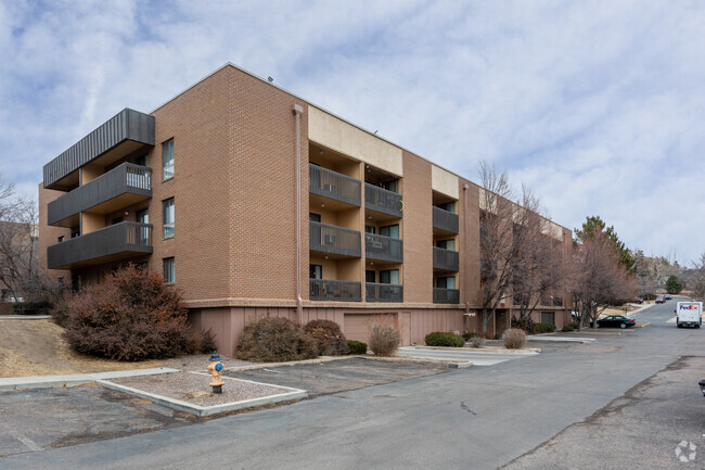
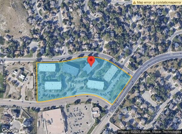
Property Record
750 S Rockrimmon Blvd, Colorado Springs, CO 80919

NEARBY LISTINGS FOR SALE OR LEASE
Property Detail
750 S Rockrimmon Blvd
Colorado Springs, CO
Comstock Village Fil No 2 Replat Of Lot
73132-04-001
LOT 1 A REPLAT OF LOT 136 COMSTOCK VILLAGE FIL NO 2 COLO SPGS
Multifamilydwelling
El Paso
X
Colorado
08041C0512G
1,136
2024
7.86 AC
2025
Oak Hills
003706
Colorado Springs
218,701 SF
DEMOGRAPHICS near 750 S Rockrimmon Blvd
1 Mile
3 Mile
5 Mile
2024 Total Population
8,942
48,278
133,367
2029 Population
9,341
50,298
138,853
Pop Growth 2024-2029
+ 4.46%
+ 4.18%
+ 4.11%
Average Age
42
41
40
2024 Total Households
3,649
20,373
55,029
HH Growth 2024-2029
+ 4.60%
+ 4.40%
+ 4.35%
Median Household Inc
$101,109
$87,019
$79,540
Avg Household Size
2.40
2.30
2.30
2024 Avg HH Vehicles
2.00
2.00
2.00
Median Home Value
$487,257
$468,769
$423,348
Median Year Built
1985
1986
1983
Nearby Places
Map Layers
Map Styles
 Street
 Aerial
- Restaurants
- Banks
- Shops
- Fitness
- Groceries
PUBLIC TRANSPORTATION
AIRPORT
City of Colorado Springs Municipal
DRIVE
WALK
Distance
City of Colorado Springs Municipal
31 min
15.6 mi
Freight Ports
Tulsa Port Of Catoosa
DRIVE
WALK
Distance
Tulsa Port Of Catoosa
740 min
692.3 mi
Nearby Properties
Address
Land Use
TOTAL SIZE
Lot Size
Zoning
Address
Land Use
TOTAL SIZE
Lot Size
Zoning
625 SF
7.15 AC
RR-5
Address
Land Use
TOTAL SIZE
Lot Size
Zoning
662,208 SF
14.96 AC
BP
Address
Land Use
TOTAL SIZE
Lot Size
Zoning
62,201 SF
5.68 AC
MX-N
Address
Land Use
TOTAL SIZE
Lot Size
Zoning
409,164 SF
19.26 AC
PUD
Address
Land Use
TOTAL SIZE
Lot Size
Zoning
117,227 SF
12.28 AC
PDZ HS
Address
Land Use
TOTAL SIZE
Lot Size
Zoning
747,294 SF
61.26 AC
BP HS
Address
Land Use
TOTAL SIZE
Lot Size
Zoning
139,621 SF
403.34 AC
A R-E HS
Address
Land Use
TOTAL SIZE
Lot Size
Zoning
77,655 SF
8.39 AC
MX-N MX-N/
Address
Land Use
TOTAL SIZE
Lot Size
Zoning
113,069 SF
44.99 AC
R-E HS
Address
Land Use
TOTAL SIZE
Lot Size
Zoning
89,592 SF
7.60 AC
R-E CU
Address
Land Use
TOTAL SIZE
Lot Size
Zoning
93,939 SF
112.21 AC
PDZ
Address
Land Use
TOTAL SIZE
Lot Size
Zoning
131,696 SF
9.24 AC
MX-M
Address
Land Use
TOTAL SIZE
Lot Size
Zoning
100,930 SF
7.75 AC
BP CU
Address
Land Use
TOTAL SIZE
Lot Size
Zoning
30,757 SF
6.19 AC
MX-N CU HS
Address
Land Use
TOTAL SIZE
Lot Size
Zoning
34,443 SF
5.14 AC
PF
Address
Land Use
TOTAL SIZE
Lot Size
Zoning
53,632 SF
3.42 AC
PF SS
Address
Land Use
TOTAL SIZE
Lot Size
Zoning
158,502 SF
5.73 AC
MX-N HS
Address
Land Use
TOTAL SIZE
Lot Size
Zoning
41,015 SF
0.62 AC
BP
Address
Land Use
TOTAL SIZE
Lot Size
Zoning
23,431 SF
0.17 AC
R-E MX-M P
Address
Land Use
TOTAL SIZE
Lot Size
Zoning
23,324 SF
7.84 AC
MX-N CU
Address
Land Use
TOTAL SIZE
Lot Size
Zoning
301,559 SF
46.67 AC
BP/CR CU H
Address
Land Use
TOTAL SIZE
Lot Size
Zoning
61,098 SF
5.93 AC
LI
Address
Land Use
TOTAL SIZE
Lot Size
Zoning
42,365 SF
3.86 AC
MX-M CU SS
Address
Land Use
TOTAL SIZE
Lot Size
Zoning
88.37 AC
BP/CR HS C
Address
Land Use
TOTAL SIZE
Lot Size
Zoning
249,958 SF
21.03 AC
BP/CR HS C
Address
Land Use
TOTAL SIZE
Lot Size
Zoning
409,070 SF
17.15 AC
Address
Land Use
TOTAL SIZE
Lot Size
Zoning
554,579 SF
97.22 AC
BP
Address
Land Use
TOTAL SIZE
Lot Size
Zoning
39,120 SF
2.16 AC
LI/CR CU
Address
Land Use
TOTAL SIZE
Lot Size
Zoning
70,999 SF
2.82 AC
C6
Address
Land Use
TOTAL SIZE
Lot Size
Zoning
39,807 SF
12.94 AC
MX-N CU UV
The World's #1 Commercial Real Estate Marketplace
Connect with us
© 2025 CoStar Group
The information above has been obtained from sources believed reliable. While we do not doubt its accuracy we have not verified it and make no guarantee, warranty or representation about it. It is your responsibility to independently confirm its accuracy and completeness. Any projections, opinions, assumptions, or estimates used are for example only and do not represent the current or future performance of the property. The value of this transaction to you depends on tax and other factors which should be evaluated by your tax, financial, and legal advisors. You and your advisors should conduct a careful, independent investigation of the property to determine to your satisfaction the suitability of the property for your needs.