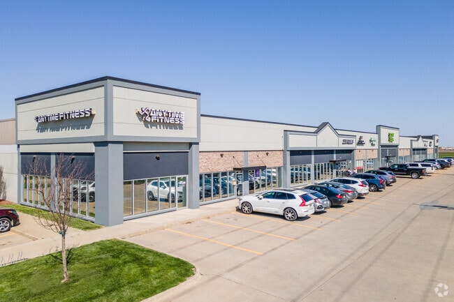
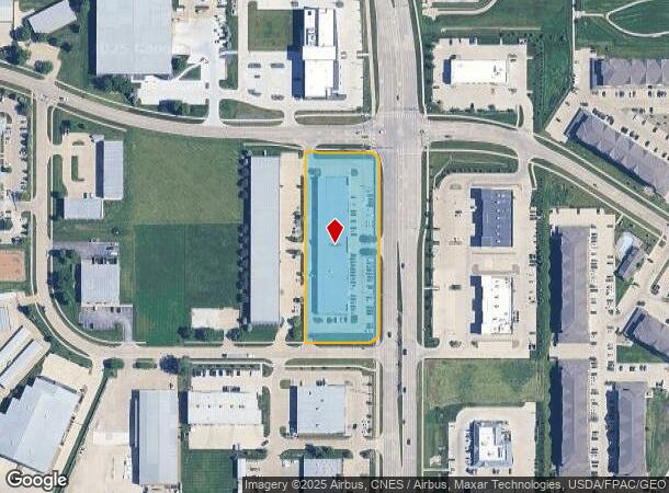
Property Record
750 Se Alices Rd, Waukee, IA 50263

NEARBY LISTINGS FOR SALE OR LEASE
Property Detail
750 Se Alices Rd
Des Moines-West Des Moines, IA
Westgate Business Park Plat 2
12-34-477-012
WESTGATE BUSINESS PARK PLAT 2 LOTS 14 & 23
Regionalshoppingcenterormallwithanchorstore
Dallas
X
Iowa
19153C0305F
14,23
2023
2.27 AC
2024
Western Suburbs
050807
Des Moines
28,800 SF
DEMOGRAPHICS near 750 Se Alices Rd
1 Mile
3 Mile
5 Mile
2024 Total Population
15,174
60,508
103,199
2029 Population
18,451
72,847
121,217
Pop Growth 2024-2029
+ 21.60%
+ 20.39%
+ 17.46%
Average Age
35
36
37
2024 Total Households
5,901
22,690
41,023
HH Growth 2024-2029
+ 22.44%
+ 21.18%
+ 17.89%
Median Household Inc
$81,492
$105,318
$97,805
Avg Household Size
2.50
2.60
2.50
2024 Avg HH Vehicles
2.00
2.00
2.00
Median Home Value
$258,338
$312,777
$315,570
Median Year Built
2009
2008
2006
Nearby Places
Map Layers
Map Styles
 Street
 Aerial
- Restaurants
- Banks
- Shops
- Fitness
- Groceries
PUBLIC TRANSPORTATION
AIRPORT
Des Moines International
DRIVE
WALK
Distance
Des Moines International
26 min
14.8 mi
Freight Ports
Port Milwaukee
DRIVE
WALK
Distance
Port Milwaukee
430 min
385.2 mi
SALE & LEASE HISTORY
LISTING DATE
SALE/LEASE

Jun 19, 2017
For Lease
Dec 07, 2016
For Lease
Apr 19, 2019
For Lease
Nearby Properties
Address
Land Use
TOTAL SIZE
Lot Size
Zoning
Address
Land Use
TOTAL SIZE
Lot Size
Zoning
72,372 SF
74.45 AC
Address
Land Use
TOTAL SIZE
Lot Size
Zoning
457,056 SF
26.01 AC
Address
Land Use
TOTAL SIZE
Lot Size
Zoning
37,325 SF
Address
Land Use
TOTAL SIZE
Lot Size
Zoning
2,864 SF
21.03 AC
Address
Land Use
TOTAL SIZE
Lot Size
Zoning
101,097 SF
30 AC
Address
Land Use
TOTAL SIZE
Lot Size
Zoning
189,660 SF
19.84 AC
Address
Land Use
TOTAL SIZE
Lot Size
Zoning
123,722 SF
64.36 AC
Address
Land Use
TOTAL SIZE
Lot Size
Zoning
38,400 SF
13.12 AC
Address
Land Use
TOTAL SIZE
Lot Size
Zoning
3,358 SF
21.13 AC
Address
Land Use
TOTAL SIZE
Lot Size
Zoning
39,229 SF
22.75 AC
Address
Land Use
TOTAL SIZE
Lot Size
Zoning
Address
Land Use
TOTAL SIZE
Lot Size
Zoning
22,093 SF
12.26 AC
Address
Land Use
TOTAL SIZE
Lot Size
Zoning
5.75 AC
Address
Land Use
TOTAL SIZE
Lot Size
Zoning
39,505 SF
4.94 AC
Address
Land Use
TOTAL SIZE
Lot Size
Zoning
17.73 AC
Address
Land Use
TOTAL SIZE
Lot Size
Zoning
17.76 AC
Address
Land Use
TOTAL SIZE
Lot Size
Zoning
87,362 SF
16.87 AC
Address
Land Use
TOTAL SIZE
Lot Size
Zoning
4,579 SF
7.44 AC
Address
Land Use
TOTAL SIZE
Lot Size
Zoning
175,860 SF
40.72 AC
Address
Land Use
TOTAL SIZE
Lot Size
Zoning
121,824 SF
14.72 AC
C-3
Address
Land Use
TOTAL SIZE
Lot Size
Zoning
3,930 SF
8.22 AC
Address
Land Use
TOTAL SIZE
Lot Size
Zoning
160,096 SF
7.11 AC
Address
Land Use
TOTAL SIZE
Lot Size
Zoning
1,616 SF
Address
Land Use
TOTAL SIZE
Lot Size
Zoning
66.16 AC
Address
Land Use
TOTAL SIZE
Lot Size
Zoning
415,636 SF
28.12 AC
Address
Land Use
TOTAL SIZE
Lot Size
Zoning
88,670 SF
15.44 AC
Address
Land Use
TOTAL SIZE
Lot Size
Zoning
89,765 SF
11.89 AC
Address
Land Use
TOTAL SIZE
Lot Size
Zoning
80,271 SF
12.38 AC
Address
Land Use
TOTAL SIZE
Lot Size
Zoning
30,943 SF
2.98 AC
The World's #1 Commercial Real Estate Marketplace
Connect with us
© 2025 CoStar Group
The information above has been obtained from sources believed reliable. While we do not doubt its accuracy we have not verified it and make no guarantee, warranty or representation about it. It is your responsibility to independently confirm its accuracy and completeness. Any projections, opinions, assumptions, or estimates used are for example only and do not represent the current or future performance of the property. The value of this transaction to you depends on tax and other factors which should be evaluated by your tax, financial, and legal advisors. You and your advisors should conduct a careful, independent investigation of the property to determine to your satisfaction the suitability of the property for your needs.