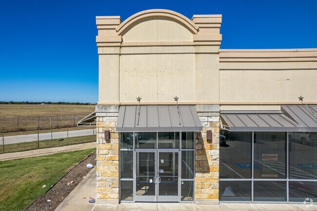
Property Record
750 State Highway 183, White Settlement, TX 76108


Current Lease Availabilities
Property Detail
750 State Highway 183
Dallas-Fort Worth-Arlington, TX
LOWES ADDITION -WHITESETTLEM BLOCK 1 LOT 3
40362310
TARRANT
Commercialnec
Texas
B and X Area of moderate flood hazard, usually the area between the limits of the 100-year and 500-year floods.
3
2025
1.30 AC
2025
West Fort Worth
114207
Dallas/Ft Worth
12,383 SF
NEARBY LISTINGS FOR SALE OR LEASE
DEMOGRAPHICS near 750 State Highway 183
1 mile
3 mile
5 mile
2025 Total Population
5,303
96,964
222,605
2030 Population
5,615
103,779
237,026
Pop Growth 2025-2030
+ 5.88%
+ 7.03%
+ 6.48%
Average Age
42
38
38
2025 Total Households
2,239
38,688
90,654
HH Growth 2025-2030
+ 6.12%
+ 6.79%
+ 6.55%
Median Household Inc
$53,823
$58,131
$67,734
Avg Household Size
2.10
2.40
2.40
2025 Avg HH Vehicles
1.00
2.00
2.00
Median Home Value
$536,043
$292,333
$305,821
Median Year Built
1978
1975
1981
Nearby Places
Map Layers
Map Styles
 Street
 Aerial
Layers
 Traffic
 Biking
Places
Listings with unknown addresses are not visible on the map
- Restaurants
- Banks
- Shops
- Fitness
- Groceries
PUBLIC TRANSPORTATION
COMMUTER RAIL
Texas And Pacific (T&P) (Trinity Railway Express - Dallas Area Rapid Transit (DART))
Drive
Walk
Distance
Texas And Pacific (T&P) (Trinity Railway Express - Dallas Area Rapid Transit (DART))
13 min
7.9 mi
Fort Worth (Heartland Flyer - Amtrak, Texas Eagle - Amtrak)
Drive
Walk
Distance
Fort Worth (Heartland Flyer - Amtrak, Texas Eagle - Amtrak)
14 min
8.3 mi
AIRPORT
Dallas-Fort Worth International
Drive
Walk
Distance
Dallas-Fort Worth International
44 min
32.8 mi
Freight Ports
Port of Shreveport
Drive
Walk
Distance
Port of Shreveport
257 min
238.1 mi
Nearby Properties
Address
Land Use
TOTAL SIZE
Lot Size
Zoning
Address
Land Use
TOTAL SIZE
Lot Size
Zoning
469,191 SF
4.20 AC
Address
Land Use
TOTAL SIZE
Lot Size
Zoning
627,866 SF
6.85 AC
Address
Land Use
TOTAL SIZE
Lot Size
Zoning
378,038 SF
7.01 AC
Address
Land Use
TOTAL SIZE
Lot Size
Zoning
401,487 SF
6.16 AC
Address
Land Use
TOTAL SIZE
Lot Size
Zoning
314,284 SF
26.29 AC
Address
Land Use
TOTAL SIZE
Lot Size
Zoning
242,244 SF
27.01 AC
Address
Land Use
TOTAL SIZE
Lot Size
Zoning
424,333 SF
12.59 AC
Address
Land Use
TOTAL SIZE
Lot Size
Zoning
315,552 SF
14.84 AC
Address
Land Use
TOTAL SIZE
Lot Size
Zoning
271,065 SF
9.03 AC
Address
Land Use
TOTAL SIZE
Lot Size
Zoning
233,269 SF
8.81 AC
Address
Land Use
TOTAL SIZE
Lot Size
Zoning
152,640 SF
15.91 AC
Address
Land Use
TOTAL SIZE
Lot Size
Zoning
215,548 SF
7.79 AC
Address
Land Use
TOTAL SIZE
Lot Size
Zoning
357,676 SF
9.03 AC
Address
Land Use
TOTAL SIZE
Lot Size
Zoning
293,358 SF
6.95 AC
Address
Land Use
TOTAL SIZE
Lot Size
Zoning
136,717 SF
12.07 AC
Address
Land Use
TOTAL SIZE
Lot Size
Zoning
284,418 SF
15.86 AC
Address
Land Use
TOTAL SIZE
Lot Size
Zoning
238,580 SF
11.56 AC
Address
Land Use
TOTAL SIZE
Lot Size
Zoning
245,043 SF
13.10 AC
Address
Land Use
TOTAL SIZE
Lot Size
Zoning
118,265 SF
6.63 AC
Address
Land Use
TOTAL SIZE
Lot Size
Zoning
321,124 SF
13.20 AC
Address
Land Use
TOTAL SIZE
Lot Size
Zoning
203,179 SF
11.57 AC
Address
Land Use
TOTAL SIZE
Lot Size
Zoning
230,766 SF
9.24 AC
Address
Land Use
TOTAL SIZE
Lot Size
Zoning
177,726 SF
8.15 AC
Address
Land Use
TOTAL SIZE
Lot Size
Zoning
125,493 SF
16.55 AC
Address
Land Use
TOTAL SIZE
Lot Size
Zoning
152,132 SF
26.16 AC
Address
Land Use
TOTAL SIZE
Lot Size
Zoning
103,270 SF
13.01 AC
Address
Land Use
TOTAL SIZE
Lot Size
Zoning
237,447 SF
12.95 AC
Address
Land Use
TOTAL SIZE
Lot Size
Zoning
161,746 SF
9.43 AC
Address
Land Use
TOTAL SIZE
Lot Size
Zoning
80,471 SF
3.51 AC
Address
Land Use
TOTAL SIZE
Lot Size
Zoning
236,934 SF
51.75 AC
The World's #1 Commercial Real Estate Marketplace
Connect with us
© 2026 CoStar Group
The information above has been obtained from sources believed reliable. While we do not doubt its accuracy we have not verified it and make no guarantee, warranty or representation about it. It is your responsibility to independently confirm its accuracy and completeness. Any projections, opinions, assumptions, or estimates used are for example only and do not represent the current or future performance of the property. The value of this transaction to you depends on tax and other factors which should be evaluated by your tax, financial, and legal advisors. You and your advisors should conduct a careful, independent investigation of the property to determine to your satisfaction the suitability of the property for your needs.