Property Record
750 Technology Dr, Goleta, CA 93117
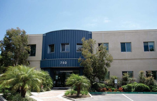


Property Detail
750 Technology Dr
Santa Maria-Santa Barbara, CA
PM 14318 BK 051/35-36 LOT 1
071-170-084
Santa Barbara
Officebuilding
California
A Areas with a 1% annual chance of flooding and a 26% chance of flooding over the life of a 30-year mortgage.
1
2024
2.86 AC
2025
Santa Barbara Airport
003001
Santa Barbara/Sta Maria/Goleta
NEARBY LISTINGS FOR SALE OR LEASE
DEMOGRAPHICS near 750 Technology Dr
1 mile
3 mile
5 mile
2025 Total Population
6,117
60,086
92,107
2030 Population
6,045
60,024
92,042
Pop Growth 2025-2030
(1.18%)
(0.10%)
(0.07%)
Average Age
38
37
39
2025 Total Households
2,314
20,156
32,594
HH Growth 2025-2030
(1.08%)
+ 0.04%
+ 0.01%
Median Household Inc
$76,663
$95,532
$102,856
Avg Household Size
2.40
2.70
2.60
2025 Avg HH Vehicles
2.00
2.00
2.00
Median Home Value
$830,136
$1,088,785
$1,077,256
Median Year Built
1973
1973
1973
Nearby Places
Map Layers
Map Styles
 Street
 Aerial
Transit
 Traffic
 Biking
Places
Listings with unknown addresses are not visible on the map
- Restaurants
- Banks
- Shops
- Fitness
- Groceries
PUBLIC TRANSPORTATION
COMMUTER RAIL
Drive
Walk
Distance
6 min
1.8 mi
Drive
Walk
Distance
15 min
9.3 mi
AIRPORT
Santa Barbara Municipal
Drive
Walk
Distance
Santa Barbara Municipal
19 min
4.1 mi
SALE & LEASE HISTORY
LISTING DATE
SALE/LEASE

Jan 22, 2021
For Lease
Nearby Properties
Address
Land Use
TOTAL SIZE
Lot Size
Zoning
Address
Land Use
TOTAL SIZE
Lot Size
Zoning
13,528 SF
9.35 AC
Address
Land Use
TOTAL SIZE
Lot Size
Zoning
20.78 AC
8R1
Address
Land Use
TOTAL SIZE
Lot Size
Zoning
2.50 AC
SRH20
Address
Land Use
TOTAL SIZE
Lot Size
Zoning
5.30 AC
Address
Land Use
TOTAL SIZE
Lot Size
Zoning
1.90 AC
Address
Land Use
TOTAL SIZE
Lot Size
Zoning
13.08 AC
Address
Land Use
TOTAL SIZE
Lot Size
Zoning
8.82 AC
Address
Land Use
TOTAL SIZE
Lot Size
Zoning
4.25 AC
Address
Land Use
TOTAL SIZE
Lot Size
Zoning
Address
Land Use
TOTAL SIZE
Lot Size
Zoning
2.42 AC
SRH20
Address
Land Use
TOTAL SIZE
Lot Size
Zoning
2.18 AC
Address
Land Use
TOTAL SIZE
Lot Size
Zoning
102,570 SF
14.03 AC
Address
Land Use
TOTAL SIZE
Lot Size
Zoning
3.05 AC
Address
Land Use
TOTAL SIZE
Lot Size
Zoning
37,584 SF
2 AC
SRH20
Address
Land Use
TOTAL SIZE
Lot Size
Zoning
3.81 AC
Address
Land Use
TOTAL SIZE
Lot Size
Zoning
85,052 SF
2.97 AC
SRH20
Address
Land Use
TOTAL SIZE
Lot Size
Zoning
7.18 AC
Address
Land Use
TOTAL SIZE
Lot Size
Zoning
7.99 AC
Address
Land Use
TOTAL SIZE
Lot Size
Zoning
0.87 AC
SRH20
Address
Land Use
TOTAL SIZE
Lot Size
Zoning
109,624 SF
9.11 AC
SC
Address
Land Use
TOTAL SIZE
Lot Size
Zoning
13.74 AC
Address
Land Use
TOTAL SIZE
Lot Size
Zoning
34,688 SF
2.17 AC
Address
Land Use
TOTAL SIZE
Lot Size
Zoning
6.90 AC
Address
Land Use
TOTAL SIZE
Lot Size
Zoning
0.38 AC
C2
Address
Land Use
TOTAL SIZE
Lot Size
Zoning
5.38 AC
Address
Land Use
TOTAL SIZE
Lot Size
Zoning
1.82 AC
Address
Land Use
TOTAL SIZE
Lot Size
Zoning
10.19 AC
Address
Land Use
TOTAL SIZE
Lot Size
Zoning
5.34 AC
Address
Land Use
TOTAL SIZE
Lot Size
Zoning
68,163 SF
4.04 AC
Address
Land Use
TOTAL SIZE
Lot Size
Zoning
18.65 AC
The World's #1 Commercial Real Estate Marketplace
Connect with us
© 2026 CoStar Group
The information above has been obtained from sources believed reliable. While we do not doubt its accuracy we have not verified it and make no guarantee, warranty or representation about it. It is your responsibility to independently confirm its accuracy and completeness. Any projections, opinions, assumptions, or estimates used are for example only and do not represent the current or future performance of the property. The value of this transaction to you depends on tax and other factors which should be evaluated by your tax, financial, and legal advisors. You and your advisors should conduct a careful, independent investigation of the property to determine to your satisfaction the suitability of the property for your needs.